"G" Sketch from Gaines County

Print $20.00
- Digital $50.00
"G" Sketch from Gaines County
1902
Size: 31.7 x 21.7 inches
90839
"G" Sketch from Gaines County

Print $20.00
- Digital $50.00
"G" Sketch from Gaines County
1902
Size: 31.6 x 21.8 inches
90845
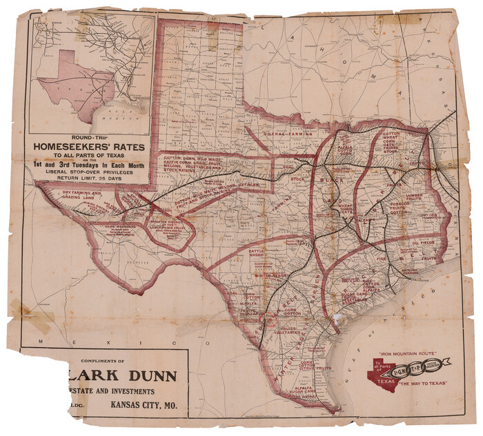
"Iron Mountain Route" to all parts of Texas - I. & G. N., T. & P., Iron Mountain - "The Way to Texas"

Print $20.00
- Digital $50.00
"Iron Mountain Route" to all parts of Texas - I. & G. N., T. & P., Iron Mountain - "The Way to Texas"
1909
Size: 22.0 x 24.0 inches
95792
"Iron Mountain Route" to all parts of Texas - I. & G. N., T. & P., Iron Mountain - "The Way to Texas"
Print $20.00
- Digital $50.00
"Iron Mountain Route" to all parts of Texas - I. & G. N., T. & P., Iron Mountain - "The Way to Texas"
1909
Size: 21.8 x 24.0 inches
95793
"K" Sketch from Loving & Winkler Counties

Print $40.00
- Digital $50.00
"K" Sketch from Loving & Winkler Counties
1902
Size: 49.4 x 39.7 inches
89938
"Old Three Hundred" Land Grants under Austin's First Contract

"Old Three Hundred" Land Grants under Austin's First Contract
2023
Size: 8.5 x 11.0 inches
97185
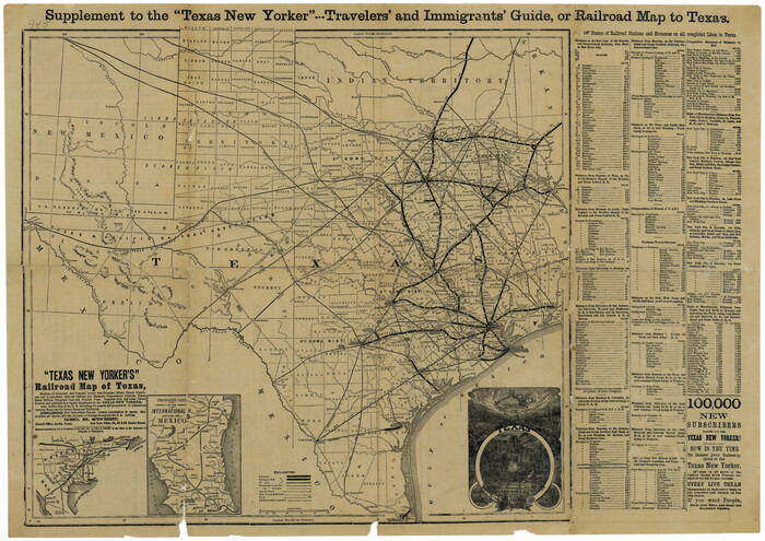
"Texas New Yorker's" Railroad Map of Texas
Print $20.00
"Texas New Yorker's" Railroad Map of Texas
1874
Size: 22.8 x 32.3 inches
76210
"The Spirit of the Alamo Lives On"
.tif.jpg)
Price $20.00
"The Spirit of the Alamo Lives On"
2009
Size: 24.0 x 36.0 inches
95290
"The Texas and Pacific Railway Company Reservation and Land Grant"

Print $38.00
- Digital $50.00
"The Texas and Pacific Railway Company Reservation and Land Grant"
1962
Size: 9.3 x 6.5 inches
62213
'The Cradle of Texas' - San Augustine

Print $20.00
- Digital $50.00
'The Cradle of Texas' - San Augustine
Size: 19.3 x 25.3 inches
94441
(A No. 2) Preliminary Sketch Showing the positions of Davis's South Shoal and other Dangers recently discovered by the Coast Survey and the soundings on the Old South Shoal, Bass Rip, Old Man, Pochick Rip &c.

Print $20.00
- Digital $50.00
(A No. 2) Preliminary Sketch Showing the positions of Davis's South Shoal and other Dangers recently discovered by the Coast Survey and the soundings on the Old South Shoal, Bass Rip, Old Man, Pochick Rip &c.
1846
Size: 19.7 x 21.8 inches
97203
170th Anniversary Land Commissioners of the Texas General Land Office

Print $20.00
- Digital $50.00
170th Anniversary Land Commissioners of the Texas General Land Office
2006
Size: 36.4 x 24.1 inches
87177
1875 land survey for the International and Great Northern Rail-road Company

Print $40.00
- Digital $50.00
1875 land survey for the International and Great Northern Rail-road Company
1875
Size: 42.5 x 60.6 inches
2306
1880 United States Population by County
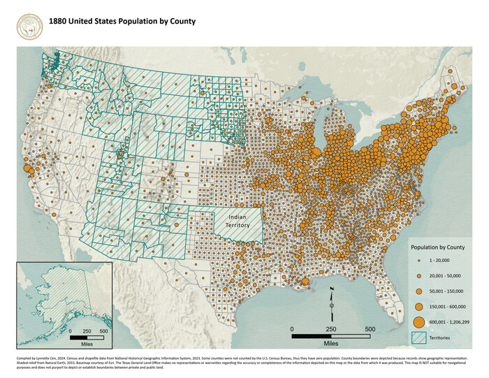
1880 United States Population by County
2024
Size: 11.0 x 8.5 inches
97284
1882 Map of the Texas & Pacific R-Y Reserve

Print $40.00
- Digital $50.00
1882 Map of the Texas & Pacific R-Y Reserve
1888
Size: 95.6 x 42.5 inches
2299
1882 Map of the Texas & Pacific R-Y Reserve

Print $20.00
- Digital $50.00
1882 Map of the Texas & Pacific R-Y Reserve
1887
Size: 44.5 x 31.7 inches
83559
1882 Map of the Texas & Pacific R-Y Reserve

Print $20.00
- Digital $50.00
1882 Map of the Texas & Pacific R-Y Reserve
1887
Size: 44.1 x 42.1 inches
83560
1882 Map of the Texas & Pacific R-Y Reserve

Print $20.00
- Digital $50.00
1882 Map of the Texas & Pacific R-Y Reserve
1887
Size: 44.6 x 29.8 inches
83561
1883 Map of the Texas & Pacific R-Y Reserve

Print $40.00
- Digital $50.00
1883 Map of the Texas & Pacific R-Y Reserve
1883
Size: 42.2 x 86.4 inches
2236
1910 Map of the City of Houston and vicinity

Print $20.00
- Digital $50.00
1910 Map of the City of Houston and vicinity
1910
Size: 20.5 x 23.4 inches
97452
1938 Tydol Trails New York

Print $20.00
- Digital $50.00
1938 Tydol Trails New York
1938
Size: 27.2 x 31.8 inches
97111
1960 Texas Official Highway Travel Map

Digital $50.00
1960 Texas Official Highway Travel Map
Size: 28.4 x 36.2 inches
94329
1960 Texas Official Highway Travel Map

Digital $50.00
1960 Texas Official Highway Travel Map
Size: 28.3 x 36.5 inches
94330


1968 Texas Official State Highway Map

Digital $50.00
1968 Texas Official State Highway Map
Size: 28.1 x 36.5 inches
94319
"G" Sketch from Gaines County
Print $20.00
- Digital $50.00
"G" Sketch from Gaines County
1902
-
Size
31.7 x 21.7 inches
-
Map/Doc
90839
-
Creation Date
1902
"G" Sketch from Gaines County
Print $20.00
- Digital $50.00
"G" Sketch from Gaines County
1902
-
Size
31.6 x 21.8 inches
-
Map/Doc
90845
-
Creation Date
1902
"Iron Mountain Route" to all parts of Texas - I. & G. N., T. & P., Iron Mountain - "The Way to Texas"
Print $20.00
- Digital $50.00
"Iron Mountain Route" to all parts of Texas - I. & G. N., T. & P., Iron Mountain - "The Way to Texas"
1909
-
Size
22.0 x 24.0 inches
-
Map/Doc
95792
-
Creation Date
1909
"Iron Mountain Route" to all parts of Texas - I. & G. N., T. & P., Iron Mountain - "The Way to Texas"
Print $20.00
- Digital $50.00
"Iron Mountain Route" to all parts of Texas - I. & G. N., T. & P., Iron Mountain - "The Way to Texas"
1909
-
Size
21.8 x 24.0 inches
-
Map/Doc
95793
-
Creation Date
1909
"K" Sketch from Loving & Winkler Counties
Print $40.00
- Digital $50.00
"K" Sketch from Loving & Winkler Counties
1902
-
Size
49.4 x 39.7 inches
-
Map/Doc
89938
-
Creation Date
1902
"Land of Hearts Delight"

Print $30.00
"Land of Hearts Delight"
1920
-
Map/Doc
96731
-
Creation Date
1920
"Old Three Hundred" Land Grants under Austin's First Contract
"Old Three Hundred" Land Grants under Austin's First Contract
2023
-
Size
8.5 x 11.0 inches
-
Map/Doc
97185
-
Creation Date
2023
"Texas New Yorker's" Railroad Map of Texas
Print $20.00
"Texas New Yorker's" Railroad Map of Texas
1874
-
Size
22.8 x 32.3 inches
-
Map/Doc
76210
-
Creation Date
1874
"The Spirit of the Alamo Lives On"
Print $20.00
"The Spirit of the Alamo Lives On"
2009
Created by artist George L. Skypeck, "The Spirit of the Alamo Lives On" commemorates the storied...
-
Size
24.0 x 36.0 inches
-
Map/Doc
95290
-
Creation Date
2009
"The Texas and Pacific Railway Company Reservation and Land Grant"
Print $38.00
- Digital $50.00
"The Texas and Pacific Railway Company Reservation and Land Grant"
1962
-
Size
9.3 x 6.5 inches
-
Map/Doc
62213
-
Creation Date
1962
'O Bar O' Ranch

Print $20.00
- Digital $50.00
'O Bar O' Ranch
1946
-
Size
21.1 x 36.2 inches
-
Map/Doc
92162
-
Creation Date
1946
'O Bar O' Ranch

Print $40.00
- Digital $50.00
'O Bar O' Ranch
1946
-
Size
47.8 x 82.6 inches
-
Map/Doc
93202
-
Creation Date
1946
'O Bar O' Ranch

Print $40.00
- Digital $50.00
'O Bar O' Ranch
1946
-
Size
46.2 x 80.7 inches
-
Map/Doc
93209
-
Creation Date
1946
'The Cradle of Texas' - San Augustine
Print $20.00
- Digital $50.00
'The Cradle of Texas' - San Augustine
-
Size
19.3 x 25.3 inches
-
Map/Doc
94441
(A No. 2) Preliminary Sketch Showing the positions of Davis's South Shoal and other Dangers recently discovered by the Coast Survey and the soundings on the Old South Shoal, Bass Rip, Old Man, Pochick Rip &c.
Print $20.00
- Digital $50.00
(A No. 2) Preliminary Sketch Showing the positions of Davis's South Shoal and other Dangers recently discovered by the Coast Survey and the soundings on the Old South Shoal, Bass Rip, Old Man, Pochick Rip &c.
1846
-
Size
19.7 x 21.8 inches
-
Map/Doc
97203
-
Creation Date
1846
170th Anniversary Land Commissioners of the Texas General Land Office
Print $20.00
- Digital $50.00
170th Anniversary Land Commissioners of the Texas General Land Office
2006
-
Size
36.4 x 24.1 inches
-
Map/Doc
87177
-
Creation Date
2006
1875 land survey for the International and Great Northern Rail-road Company
Print $40.00
- Digital $50.00
1875 land survey for the International and Great Northern Rail-road Company
1875
-
Size
42.5 x 60.6 inches
-
Map/Doc
2306
-
Creation Date
1875
1880 United States Population by County
1880 United States Population by County
2024
-
Size
11.0 x 8.5 inches
-
Map/Doc
97284
-
Creation Date
2024
1882 Map of the Texas & Pacific R-Y Reserve
Print $40.00
- Digital $50.00
1882 Map of the Texas & Pacific R-Y Reserve
1888
-
Size
95.6 x 42.5 inches
-
Map/Doc
2299
-
Creation Date
1888
1882 Map of the Texas & Pacific R-Y Reserve
Print $20.00
- Digital $50.00
1882 Map of the Texas & Pacific R-Y Reserve
1887
-
Size
44.5 x 31.7 inches
-
Map/Doc
83559
-
Creation Date
1887
1882 Map of the Texas & Pacific R-Y Reserve
Print $20.00
- Digital $50.00
1882 Map of the Texas & Pacific R-Y Reserve
1887
-
Size
44.1 x 42.1 inches
-
Map/Doc
83560
-
Creation Date
1887
1882 Map of the Texas & Pacific R-Y Reserve
Print $20.00
- Digital $50.00
1882 Map of the Texas & Pacific R-Y Reserve
1887
-
Size
44.6 x 29.8 inches
-
Map/Doc
83561
-
Creation Date
1887
1883 Map of the Texas & Pacific R-Y Reserve
Print $40.00
- Digital $50.00
1883 Map of the Texas & Pacific R-Y Reserve
1883
-
Size
42.2 x 86.4 inches
-
Map/Doc
2236
-
Creation Date
1883
1910 Map of the City of Houston and vicinity
Print $20.00
- Digital $50.00
1910 Map of the City of Houston and vicinity
1910
-
Size
20.5 x 23.4 inches
-
Map/Doc
97452
-
Creation Date
1910
1938 Tydol Trails New York
Print $20.00
- Digital $50.00
1938 Tydol Trails New York
1938
-
Size
27.2 x 31.8 inches
-
Map/Doc
97111
-
Creation Date
1938
1960 Texas Official Highway Travel Map
Digital $50.00
1960 Texas Official Highway Travel Map
-
Size
28.4 x 36.2 inches
-
Map/Doc
94329
1960 Texas Official Highway Travel Map
Digital $50.00
1960 Texas Official Highway Travel Map
-
Size
28.3 x 36.5 inches
-
Map/Doc
94330
1968 Texas Official State Highway Map
Digital $50.00
1968 Texas Official State Highway Map
-
Size
28.1 x 36.5 inches
-
Map/Doc
94319