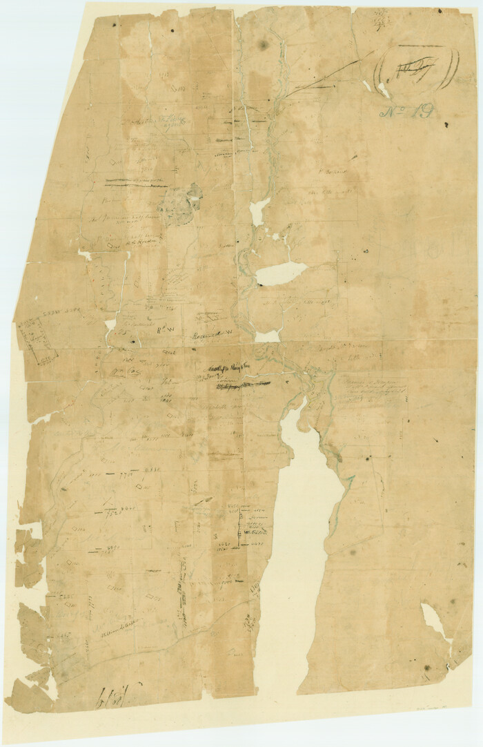
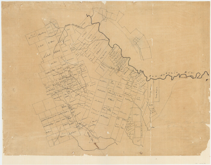
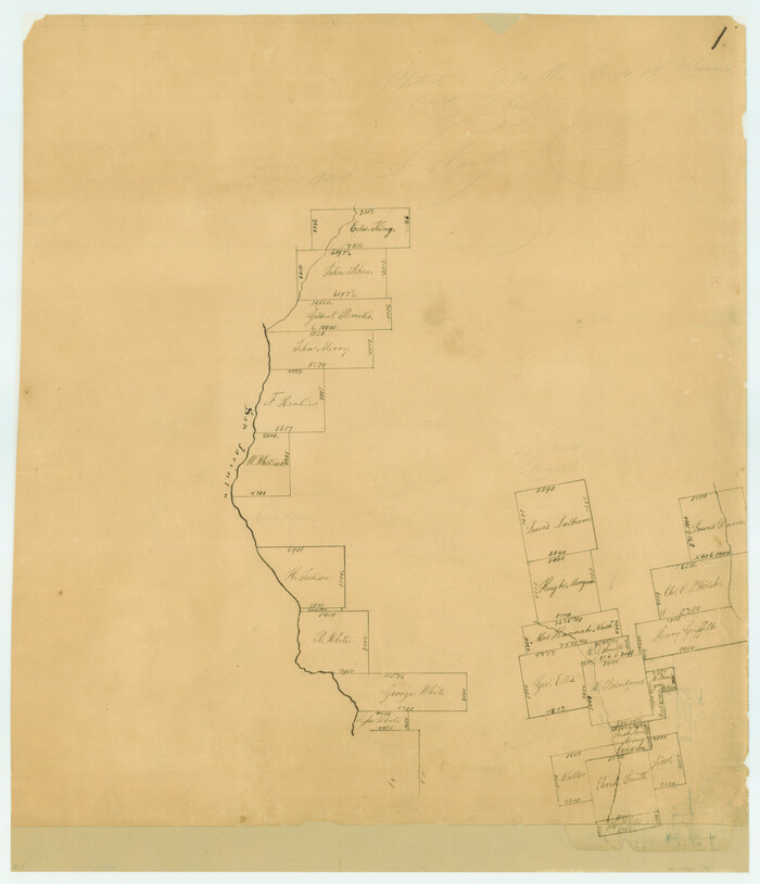
Map of the lower surveys in Robertsons Colony Sold by the State of Coahuila and Texas

Print $20.00
- Digital $50.00
Map of the lower surveys in Robertsons Colony Sold by the State of Coahuila and Texas
1834
Size: 22.0 x 28.5 inches
122
[Surveys in Austin's Colony at Matagorda Bay and along the Trespalacios and Colorado Rivers]
Print $20.00
- Digital $50.00
[Surveys in Austin's Colony at Matagorda Bay and along the Trespalacios and Colorado Rivers]
1821
Size: 31.6 x 20.5 inches
147
[Surveys in Austin's Colony along the San Antonio Road and the Colorado River]
Print $20.00
- Digital $50.00
[Surveys in Austin's Colony along the San Antonio Road and the Colorado River]
1821
Size: 17.3 x 25.6 inches
15
Connected Map of DeWitt's Colony compiled from the surveys of Byrd Lockhart

Print $40.00
- Digital $50.00
Connected Map of DeWitt's Colony compiled from the surveys of Byrd Lockhart
1831
Size: 39.2 x 54.0 inches
1942
[Surveys in Power and Hewetson's Colony]
Print $20.00
- Digital $50.00
[Surveys in Power and Hewetson's Colony]
1830
Size: 21.3 x 22.5 inches
2
[Surveys in Austin's Colony near La Bahia Road]
Print $20.00
- Digital $50.00
[Surveys in Austin's Colony near La Bahia Road]
1821
Size: 10.4 x 20.2 inches
200
[Surveys in Austin's Colony along the San Bernardo River from the mouth of Peach Creek]
Print $20.00
- Digital $50.00
[Surveys in Austin's Colony along the San Bernardo River from the mouth of Peach Creek]
1821
Size: 23.4 x 10.6 inches
209
[Surveys in Austin's Colony along New Year's Creek and near the Brazos River]
Print $20.00
- Digital $50.00
[Surveys in Austin's Colony along New Year's Creek and near the Brazos River]
1821
Size: 17.4 x 14.9 inches
218
[Surveys in Power and Hewetson's Colony along the San Antonio and Guadalupe Rivers]
Print $20.00
- Digital $50.00
[Surveys in Power and Hewetson's Colony along the San Antonio and Guadalupe Rivers]
1837
Size: 14.9 x 16.5 inches
23
[Surveys in Vehlein's Colony along the San Jacinto River]
Print $20.00
- Digital $50.00
[Surveys in Vehlein's Colony along the San Jacinto River]
1837
Size: 19.4 x 15.7 inches
27
[Surveys in McMullen and McGloin's Colony along the San Antonio River]
Print $20.00
- Digital $50.00
[Surveys in McMullen and McGloin's Colony along the San Antonio River]
1828
Size: 19.3 x 24.5 inches
30
[Surveys in the Bexar and San Patricio Districts along the Nueces and Frio Rivers]
Print $20.00
- Digital $50.00
[Surveys in the Bexar and San Patricio Districts along the Nueces and Frio Rivers]
1830
Size: 21.5 x 27.3 inches
36
Map of Shelby County

Print $20.00
- Digital $50.00
Map of Shelby County
1839
Size: 24.5 x 25.7 inches
4032
[Surveys in DeLeon's Colony along the Garcitas River and Arenosa Creek, including the Victoria town tract]
Print $20.00
- Digital $50.00
[Surveys in DeLeon's Colony along the Garcitas River and Arenosa Creek, including the Victoria town tract]
1824
Size: 22.1 x 17.6 inches
42
[Surveys along the Red River, Bois d'Arc Creek, Duck Creek, and Choctaw Bayou made under G.W. Smyth, Commissioner]
Print $20.00
- Digital $50.00
[Surveys along the Red River, Bois d'Arc Creek, Duck Creek, and Choctaw Bayou made under G.W. Smyth, Commissioner]
1834
Size: 19.7 x 16.0 inches
74
[Surveys in Vehlein's Colony along the San Jacinto River and Cedar Bayou]
Print $20.00
- Digital $50.00
[Surveys in Vehlein's Colony along the San Jacinto River and Cedar Bayou]
1837
Size: 17.5 x 15.1 inches
75
Carte du Mexique ou de la Nouvelle Espagne

Print $20.00
Carte du Mexique ou de la Nouvelle Espagne
1750
Size: 12.4 x 15.5 inches
79741
[Surveys in Austin's Colony along the Navasota River and Ten Mile Creek]
Print $20.00
- Digital $50.00
[Surveys in Austin's Colony along the Navasota River and Ten Mile Creek]
1821
Size: 29.2 x 18.0 inches
80
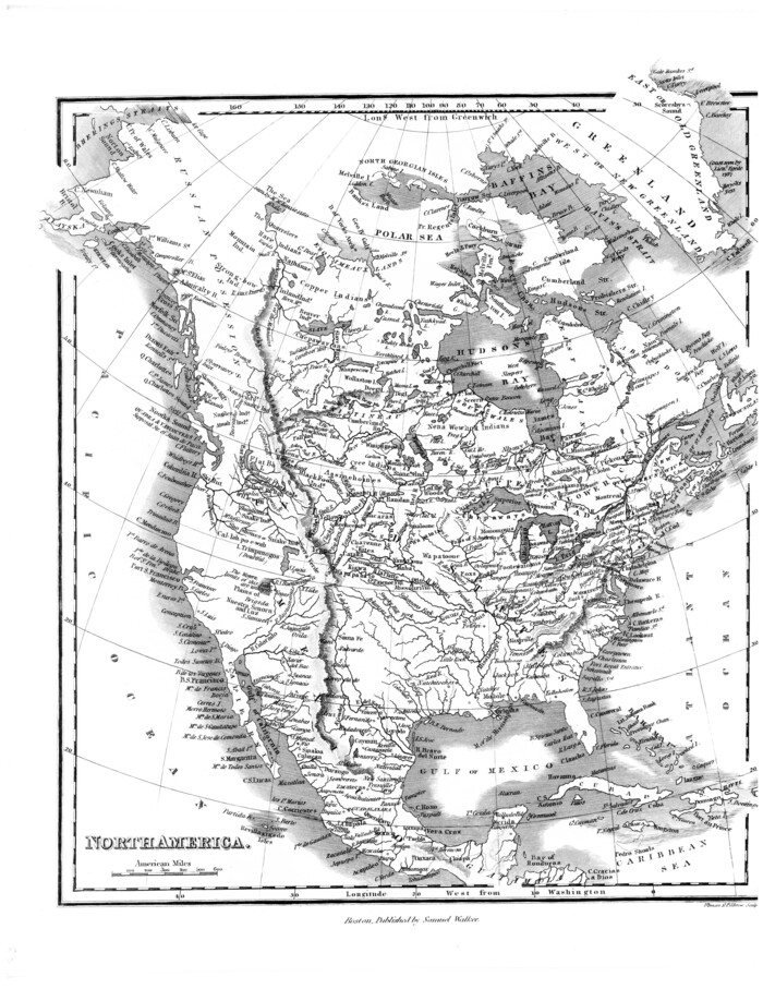
[Map of] North America
Print $3.00
- Digital $50.00
[Map of] North America
1834
Size: 11.0 x 8.5 inches
88884
Connected Map of Austin's Colony

Print $20.00
- Digital $50.00
Connected Map of Austin's Colony
1833
Size: 38.1 x 36.1 inches
88999
[Surveys along the Sabine River made under G.W. Smyth, Commissioner]
Print $20.00
- Digital $50.00
[Surveys along the Sabine River made under G.W. Smyth, Commissioner]
1837
Size: 13.9 x 17.0 inches
90
A Map of Austin's Colony and adjacent country in Texas drawn principally from actual survey by Stephen F. Austin

A Map of Austin's Colony and adjacent country in Texas drawn principally from actual survey by Stephen F. Austin
1820
Size: 13.8 x 17.0 inches
93353
Registro de las de los documentos y títulos espedidos en la primera empresa de colonización del empresario Estevan F. Austin en Tejas (1827)

Registro de las de los documentos y títulos espedidos en la primera empresa de colonización del empresario Estevan F. Austin en Tejas (1827)
1827
Size: 18.9 x 13.8 inches
94248
Transcribed English Field Notes from Austin's Colonies and Transcribed Spanish Titles from Robertson's Colony, 1825-1835

Transcribed English Field Notes from Austin's Colonies and Transcribed Spanish Titles from Robertson's Colony, 1825-1835
1825
Size: 17.0 x 12.1 inches
94532
Translations & Index to Field Notes of Spanish Titles, Vol. 1

Translations & Index to Field Notes of Spanish Titles, Vol. 1
1940
94551
Spanish Dominions in North America, Northern Part

Print $20.00
- Digital $50.00
Spanish Dominions in North America, Northern Part
1811
Size: 22.1 x 30.5 inches
95133
Deputy Surveyors Field Note Book, San Patricio County

Deputy Surveyors Field Note Book, San Patricio County
1838
96675
Surveys on the Coleto Creek, Goliad County

Print $20.00
- Digital $50.00
Surveys on the Coleto Creek, Goliad County
1841
Size: 13.8 x 14.9 inches
10
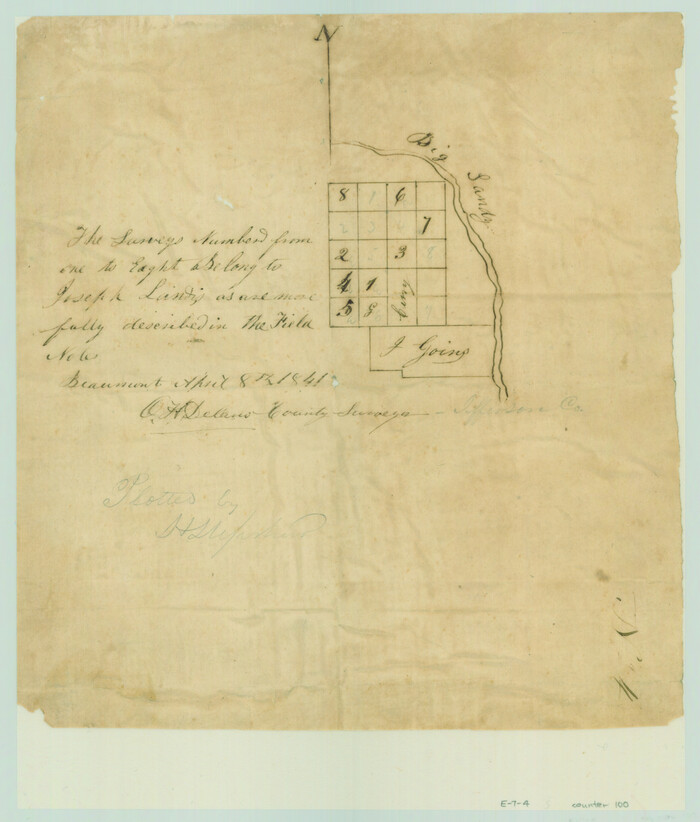
[Surveys in the Jefferson District along Big Sandy Creek]
Print $2.00
- Digital $50.00
[Surveys in the Jefferson District along Big Sandy Creek]
1841
Size: 9.5 x 8.1 inches
100
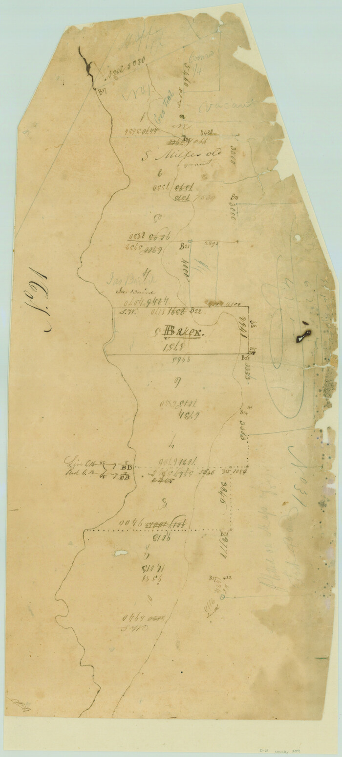
Map of the lower surveys in Robertsons Colony Sold by the State of Coahuila and Texas
Print $20.00
- Digital $50.00
Map of the lower surveys in Robertsons Colony Sold by the State of Coahuila and Texas
1834
-
Size
22.0 x 28.5 inches
-
Map/Doc
122
-
Creation Date
1834
[Surveys in Austin's Colony at Matagorda Bay and along the Trespalacios and Colorado Rivers]
Print $20.00
- Digital $50.00
[Surveys in Austin's Colony at Matagorda Bay and along the Trespalacios and Colorado Rivers]
1821
-
Size
31.6 x 20.5 inches
-
Map/Doc
147
-
Creation Date
1821
[Surveys in Austin's Colony along the San Antonio Road and the Colorado River]
Print $20.00
- Digital $50.00
[Surveys in Austin's Colony along the San Antonio Road and the Colorado River]
1821
-
Size
17.3 x 25.6 inches
-
Map/Doc
15
-
Creation Date
1821
Connected Map of DeWitt's Colony compiled from the surveys of Byrd Lockhart
Print $40.00
- Digital $50.00
Connected Map of DeWitt's Colony compiled from the surveys of Byrd Lockhart
1831
-
Size
39.2 x 54.0 inches
-
Map/Doc
1942
-
Creation Date
1831
[Surveys in Power and Hewetson's Colony]
Print $20.00
- Digital $50.00
[Surveys in Power and Hewetson's Colony]
1830
-
Size
21.3 x 22.5 inches
-
Map/Doc
2
-
Creation Date
1830
[Surveys in Austin's Colony near La Bahia Road]
Print $20.00
- Digital $50.00
[Surveys in Austin's Colony near La Bahia Road]
1821
-
Size
10.4 x 20.2 inches
-
Map/Doc
200
-
Creation Date
1821
[Surveys in Austin's Colony along the San Bernardo River from the mouth of Peach Creek]
Print $20.00
- Digital $50.00
[Surveys in Austin's Colony along the San Bernardo River from the mouth of Peach Creek]
1821
-
Size
23.4 x 10.6 inches
-
Map/Doc
209
-
Creation Date
1821
[Surveys in Austin's Colony along New Year's Creek and near the Brazos River]
Print $20.00
- Digital $50.00
[Surveys in Austin's Colony along New Year's Creek and near the Brazos River]
1821
-
Size
17.4 x 14.9 inches
-
Map/Doc
218
-
Creation Date
1821
[Surveys in Power and Hewetson's Colony along the San Antonio and Guadalupe Rivers]
Print $20.00
- Digital $50.00
[Surveys in Power and Hewetson's Colony along the San Antonio and Guadalupe Rivers]
1837
-
Size
14.9 x 16.5 inches
-
Map/Doc
23
-
Creation Date
1837
[Surveys in Vehlein's Colony along the San Jacinto River]
Print $20.00
- Digital $50.00
[Surveys in Vehlein's Colony along the San Jacinto River]
1837
-
Size
19.4 x 15.7 inches
-
Map/Doc
27
-
Creation Date
1837
[Surveys in McMullen and McGloin's Colony along the San Antonio River]
Print $20.00
- Digital $50.00
[Surveys in McMullen and McGloin's Colony along the San Antonio River]
1828
-
Size
19.3 x 24.5 inches
-
Map/Doc
30
-
Creation Date
1828
[Surveys in the Bexar and San Patricio Districts along the Nueces and Frio Rivers]
Print $20.00
- Digital $50.00
[Surveys in the Bexar and San Patricio Districts along the Nueces and Frio Rivers]
1830
-
Size
21.5 x 27.3 inches
-
Map/Doc
36
-
Creation Date
1830
Map of Shelby County
Print $20.00
- Digital $50.00
Map of Shelby County
1839
-
Size
24.5 x 25.7 inches
-
Map/Doc
4032
-
Creation Date
1839
[Surveys in DeLeon's Colony along the Garcitas River and Arenosa Creek, including the Victoria town tract]
Print $20.00
- Digital $50.00
[Surveys in DeLeon's Colony along the Garcitas River and Arenosa Creek, including the Victoria town tract]
1824
-
Size
22.1 x 17.6 inches
-
Map/Doc
42
-
Creation Date
1824
[Surveys along the Red River, Bois d'Arc Creek, Duck Creek, and Choctaw Bayou made under G.W. Smyth, Commissioner]
Print $20.00
- Digital $50.00
[Surveys along the Red River, Bois d'Arc Creek, Duck Creek, and Choctaw Bayou made under G.W. Smyth, Commissioner]
1834
-
Size
19.7 x 16.0 inches
-
Map/Doc
74
-
Creation Date
1834
[Surveys in Vehlein's Colony along the San Jacinto River and Cedar Bayou]
Print $20.00
- Digital $50.00
[Surveys in Vehlein's Colony along the San Jacinto River and Cedar Bayou]
1837
-
Size
17.5 x 15.1 inches
-
Map/Doc
75
-
Creation Date
1837
Carte du Mexique ou de la Nouvelle Espagne
Print $20.00
Carte du Mexique ou de la Nouvelle Espagne
1750
-
Size
12.4 x 15.5 inches
-
Map/Doc
79741
-
Creation Date
1750
[Surveys in Austin's Colony along the Navasota River and Ten Mile Creek]
Print $20.00
- Digital $50.00
[Surveys in Austin's Colony along the Navasota River and Ten Mile Creek]
1821
-
Size
29.2 x 18.0 inches
-
Map/Doc
80
-
Creation Date
1821
[Map of] North America
Print $3.00
- Digital $50.00
[Map of] North America
1834
-
Size
11.0 x 8.5 inches
-
Map/Doc
88884
-
Creation Date
1834
Connected Map of Austin's Colony
Print $20.00
- Digital $50.00
Connected Map of Austin's Colony
1833
-
Size
38.1 x 36.1 inches
-
Map/Doc
88999
-
Creation Date
1833
[Surveys along the Sabine River made under G.W. Smyth, Commissioner]
Print $20.00
- Digital $50.00
[Surveys along the Sabine River made under G.W. Smyth, Commissioner]
1837
-
Size
13.9 x 17.0 inches
-
Map/Doc
90
-
Creation Date
1837
A Map of Austin's Colony and adjacent country in Texas drawn principally from actual survey by Stephen F. Austin
A Map of Austin's Colony and adjacent country in Texas drawn principally from actual survey by Stephen F. Austin
1820
-
Size
13.8 x 17.0 inches
-
Map/Doc
93353
-
Creation Date
1820
Registro de las de los documentos y títulos espedidos en la primera empresa de colonización del empresario Estevan F. Austin en Tejas (1827)
Registro de las de los documentos y títulos espedidos en la primera empresa de colonización del empresario Estevan F. Austin en Tejas (1827)
1827
-
Size
18.9 x 13.8 inches
-
Map/Doc
94248
-
Creation Date
1827
Transcribed English Field Notes from Austin's Colonies and Transcribed Spanish Titles from Robertson's Colony, 1825-1835
Transcribed English Field Notes from Austin's Colonies and Transcribed Spanish Titles from Robertson's Colony, 1825-1835
1825
-
Size
17.0 x 12.1 inches
-
Map/Doc
94532
-
Creation Date
1825
Translations & Index to Field Notes of Spanish Titles, Vol. 1
Translations & Index to Field Notes of Spanish Titles, Vol. 1
1940
-
Map/Doc
94551
-
Creation Date
1940
Index to Titles, 1832-1835

Index to Titles, 1832-1835
1832
-
Size
17.3 x 18.4 inches
-
Map/Doc
94556
-
Creation Date
1832
Spanish Dominions in North America, Northern Part
Print $20.00
- Digital $50.00
Spanish Dominions in North America, Northern Part
1811
-
Size
22.1 x 30.5 inches
-
Map/Doc
95133
-
Creation Date
1811
Deputy Surveyors Field Note Book, San Patricio County
Deputy Surveyors Field Note Book, San Patricio County
1838
-
Map/Doc
96675
-
Creation Date
1838
Surveys on the Coleto Creek, Goliad County
Print $20.00
- Digital $50.00
Surveys on the Coleto Creek, Goliad County
1841
-
Size
13.8 x 14.9 inches
-
Map/Doc
10
-
Creation Date
1841
[Surveys in the Jefferson District along Big Sandy Creek]
Print $2.00
- Digital $50.00
[Surveys in the Jefferson District along Big Sandy Creek]
1841
-
Size
9.5 x 8.1 inches
-
Map/Doc
100
-
Creation Date
1841