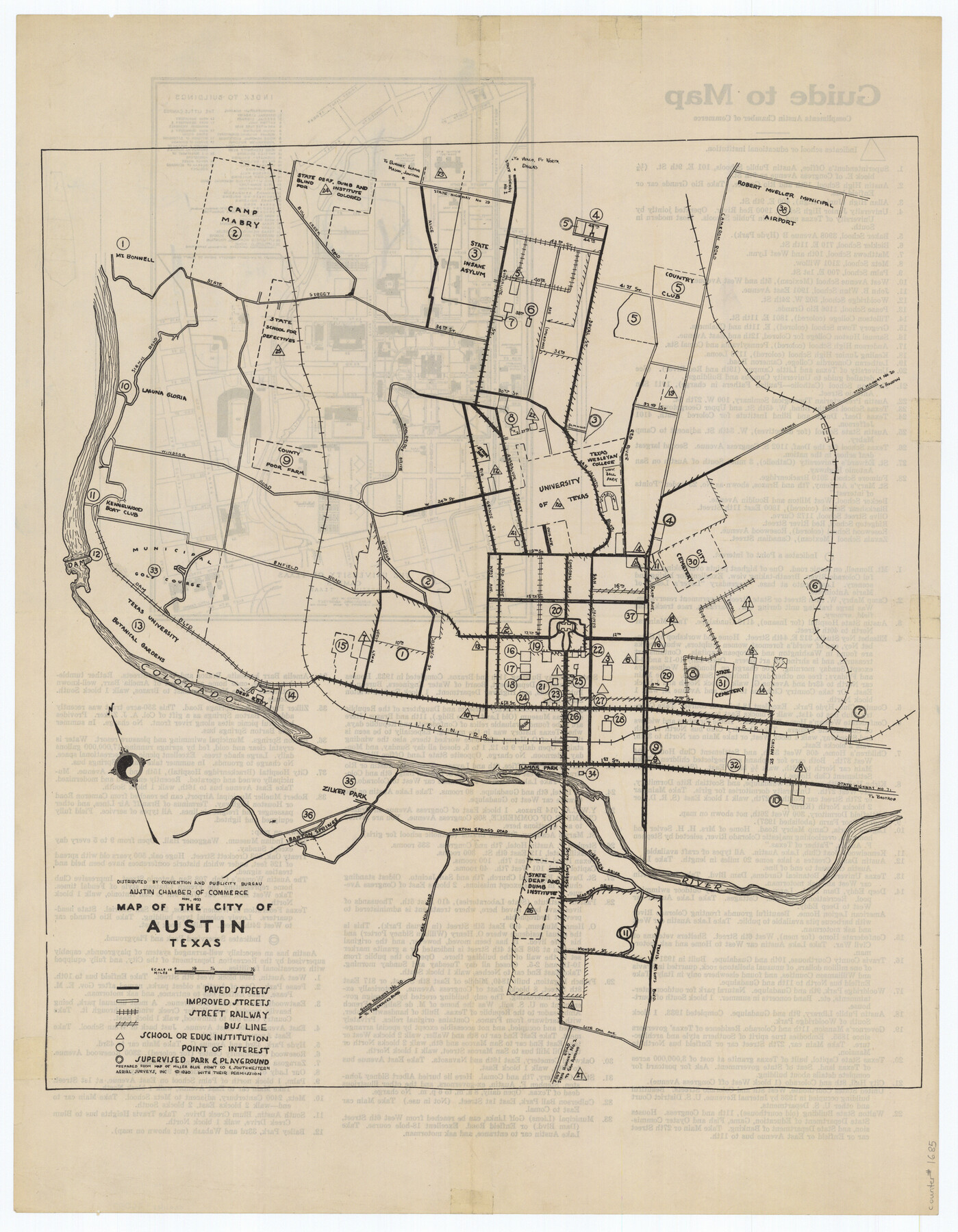
Map of the City of Austin Texas
A-6-25
-
Map/Doc
1685
-
Collection
General Map Collection
-
Object Dates
1933 (Creation Date)
-
People and Organizations
Austin Chamber of Commerce (Publisher)
-
Counties
Travis
-
Subjects
City
-
Height x Width
22.6 x 17.6 inches
57.4 x 44.7 cm
-
Medium
paper, print
-
Comments
For a guide to the map, see counter no. 76050. Available for research only---copyrighted and unavailable for duplication.
-
Features
Seton Inf[irmary]
Zilker Park
Highway to Fredericksburg
Highway to San Antonio
Barton Springs
I&GN
Highway to Bastrop
State Highway No. 71
State Cemetery
Colorado River
City Cemetery
Highway to Houston
State Highway No. 20
Texas Wesleyan College
University of Texas
Austin
Robert Mueller Municipal Airport
Highway to Dallas
Highway to Ft. Worth
Highway to Waco
Highway to Waco, Ft. Worth, Dallas
State Highway No. 2
Highway to Junction
Highway to Mason
Highway to Llano
Highway to Burnet
Highway to Burnet, Llano, Mason, Junction
State Highway No. 29
Camp Mabry
Mt. Bonnell
Related maps
Map of the City of Austin Texas

Map of the City of Austin Texas
1933
Size 22.5 x 17.6 inches
Map/Doc 76050
Part of: General Map Collection
Hardeman County Sketch File 15

Print $20.00
- Digital $50.00
Hardeman County Sketch File 15
Size 18.9 x 17.9 inches
Map/Doc 11627
Township 8 South Range 13 West, South Western District, Louisiana

Print $20.00
- Digital $50.00
Township 8 South Range 13 West, South Western District, Louisiana
1879
Size 19.5 x 24.8 inches
Map/Doc 65888
Aransas County Sketch File 29

Print $24.00
- Digital $50.00
Aransas County Sketch File 29
Size 7.8 x 8.1 inches
Map/Doc 13234
Schleicher County Sketch File 42

Print $40.00
- Digital $50.00
Schleicher County Sketch File 42
1963
Size 16.3 x 14.4 inches
Map/Doc 36546
Galveston County Rolled Sketch 27A

Print $20.00
- Digital $50.00
Galveston County Rolled Sketch 27A
1978
Size 32.2 x 35.5 inches
Map/Doc 5962
Hardin County Sketch File 15

Print $6.00
- Digital $50.00
Hardin County Sketch File 15
Size 9.0 x 4.9 inches
Map/Doc 25122
Terry County Rolled Sketch 4

Print $20.00
- Digital $50.00
Terry County Rolled Sketch 4
Size 38.7 x 36.8 inches
Map/Doc 9994
Lee County Working Sketch 16

Print $4.00
- Digital $50.00
Lee County Working Sketch 16
1982
Size 20.5 x 13.5 inches
Map/Doc 70395
San Patricio County Sketch File 20

Print $14.00
San Patricio County Sketch File 20
1868
Size 9.2 x 8.5 inches
Map/Doc 36069
Bee County Sketch File 16

Print $4.00
- Digital $50.00
Bee County Sketch File 16
1878
Size 8.6 x 7.7 inches
Map/Doc 14299
Fractional Township No. 9 South Range No. 10 East of the Indian Meridian, Indian Territory

Print $20.00
- Digital $50.00
Fractional Township No. 9 South Range No. 10 East of the Indian Meridian, Indian Territory
1898
Size 19.3 x 24.3 inches
Map/Doc 75219

You may also like
Pecos County Sketch File 97

Print $6.00
- Digital $50.00
Pecos County Sketch File 97
1957
Size 11.4 x 17.2 inches
Map/Doc 34000
General Highway Map. Detail of Cities and Towns in Bell County, Texas [Killeen and Holland, etc.]
![79367, General Highway Map. Detail of Cities and Towns in Bell County, Texas [Killeen and Holland, etc.], Texas State Library and Archives](https://historictexasmaps.com/wmedia_w700/maps/79367.tif.jpg)
Print $20.00
General Highway Map. Detail of Cities and Towns in Bell County, Texas [Killeen and Holland, etc.]
1961
Size 18.2 x 25.0 inches
Map/Doc 79367
Flight Mission No. DIX-7P, Frame 20, Aransas County

Print $20.00
- Digital $50.00
Flight Mission No. DIX-7P, Frame 20, Aransas County
1956
Size 18.8 x 22.5 inches
Map/Doc 83872
Randall County

Print $20.00
- Digital $50.00
Randall County
1917
Size 45.2 x 38.9 inches
Map/Doc 73339
Lipscomb County Boundary File 8

Print $4.00
- Digital $50.00
Lipscomb County Boundary File 8
Size 11.1 x 8.6 inches
Map/Doc 56333
The Republic County of Gonzales. Boundaries Defined, December 14, 1837

Print $20.00
The Republic County of Gonzales. Boundaries Defined, December 14, 1837
2020
Size 14.7 x 21.7 inches
Map/Doc 96153
Edwards County Rolled Sketch 20

Print $20.00
- Digital $50.00
Edwards County Rolled Sketch 20
1947
Size 31.6 x 40.4 inches
Map/Doc 8844
Hudspeth County Rolled Sketch 76

Print $40.00
- Digital $50.00
Hudspeth County Rolled Sketch 76
1992
Size 49.5 x 37.7 inches
Map/Doc 9239
Padre Island National Seashore

Print $4.00
- Digital $50.00
Padre Island National Seashore
Size 16.1 x 22.1 inches
Map/Doc 60531
San Jacinto County Working Sketch 42a
Print $20.00
- Digital $50.00
San Jacinto County Working Sketch 42a
Size 20.2 x 39.2 inches
Map/Doc 63755
Flight Mission No. BQR-22K, Frame 34, Brazoria County

Print $20.00
- Digital $50.00
Flight Mission No. BQR-22K, Frame 34, Brazoria County
1953
Size 18.7 x 22.5 inches
Map/Doc 84118
Map of Jones County, Texas

Print $20.00
Map of Jones County, Texas
1879
Size 24.7 x 18.8 inches
Map/Doc 88960