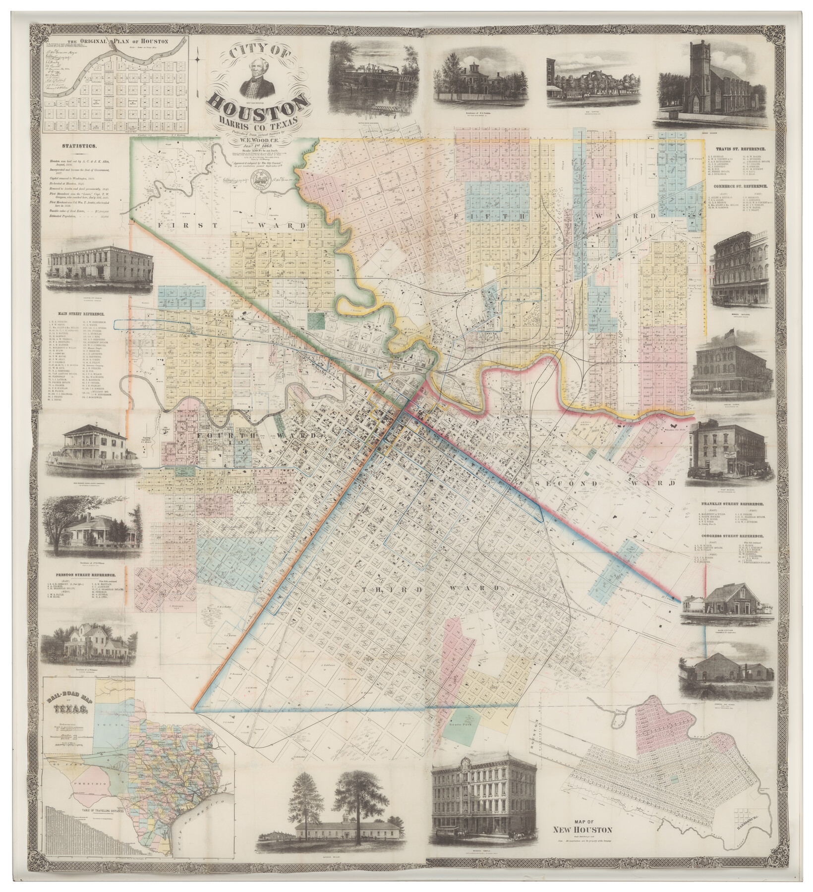
City of Houston
-
Map/Doc
93637
-
Collection
Non-GLO Digital Images
-
Object Dates
1869 (Creation Date)
-
People and Organizations
W.E. Wood (Publisher)
W.H. Rease (Printer)
-
Subjects
City
-
Height x Width
44.9 x 40.9 inches
114.1 x 103.9 cm
-
Medium
digital image
-
Comments
This map was scanned for the benefit of the Texas State Historical Association courtesy of Mary Jon & J.P. Bryan's "Visions of the West" Collection. Original map is 69.1" x 62.9" but the reproduction is printed at 65% due to printer size limitations.
Part of: Non-GLO Digital Images
Bird's Eye View of Schulenburg, Fayette County, Texas

Print $20.00
Bird's Eye View of Schulenburg, Fayette County, Texas
1881
Size 18.6 x 31.0 inches
Map/Doc 89206
[Divisional Boundary and Brigade Boundary on October 22, 1918, Appendix P]
![94125, [Divisional Boundary and Brigade Boundary on October 22, 1918, Appendix P], Non-GLO Digital Images](https://historictexasmaps.com/wmedia_w700/maps/94125-1.tif.jpg)
Print $20.00
[Divisional Boundary and Brigade Boundary on October 22, 1918, Appendix P]
1918
Size 16.2 x 16.7 inches
Map/Doc 94125
The Official Map of the City of El Paso, State of Texas

Print $20.00
The Official Map of the City of El Paso, State of Texas
1889
Size 41.9 x 46.2 inches
Map/Doc 89618
The Official Map of the City of El Paso, State of Texas

Print $20.00
The Official Map of the City of El Paso, State of Texas
1889
Size 42.1 x 49.6 inches
Map/Doc 89616

Carte de la Louisiane et du Cours du Mississipi

Print $20.00
Carte de la Louisiane et du Cours du Mississipi
1718
Size 16.6 x 21.8 inches
Map/Doc 89216
[Defensive Positions of the 143rd & 144th Infantry on October 14, 1918]
![94137, [Defensive Positions of the 143rd & 144th Infantry on October 14, 1918], Non-GLO Digital Images](https://historictexasmaps.com/wmedia_w700/maps/94137-1.tif.jpg)
Print $20.00
[Defensive Positions of the 143rd & 144th Infantry on October 14, 1918]
1918
Size 42.2 x 30.0 inches
Map/Doc 94137
Bird's Eye View of New Braunfels, Comal County, Texas

Print $20.00
Bird's Eye View of New Braunfels, Comal County, Texas
1881
Size 17.0 x 24.1 inches
Map/Doc 89200
Map of New York and Adjacent Cities

Print $20.00
- Digital $50.00
Map of New York and Adjacent Cities
1860
Size 17.8 x 28.7 inches
Map/Doc 94439


[Movements & Objectives of the 143rd & 144th Infantry & 133rd Machine Gun Battalion on October 8-9, 1918, Appendix E, No. 4]
![94133, [Movements & Objectives of the 143rd & 144th Infantry & 133rd Machine Gun Battalion on October 8-9, 1918, Appendix E, No. 4], Non-GLO Digital Images](https://historictexasmaps.com/wmedia_w700/maps/94133-1.tif.jpg)
Print $20.00
[Movements & Objectives of the 143rd & 144th Infantry & 133rd Machine Gun Battalion on October 8-9, 1918, Appendix E, No. 4]
1918
Size 21.5 x 20.2 inches
Map/Doc 94133
You may also like
[WWI Topographic Planning Map of the Ardennes department] - Verso
![94130, [WWI Topographic Planning Map of the Ardennes department] - Verso, Non-GLO Digital Images](https://historictexasmaps.com/wmedia_w700/maps/94130-1.tif.jpg)
Print $20.00
[WWI Topographic Planning Map of the Ardennes department] - Verso
1918
Size 35.9 x 20.4 inches
Map/Doc 94130
Crockett County Working Sketch 44

Print $20.00
- Digital $50.00
Crockett County Working Sketch 44
1933
Size 34.2 x 17.4 inches
Map/Doc 68377
[Texas & Pacific Block 32, T-4-N showing ties to triangulation stations]
![90143, [Texas & Pacific Block 32, T-4-N showing ties to triangulation stations], Twichell Survey Records](https://historictexasmaps.com/wmedia_w700/maps/90143-1.tif.jpg)
Print $20.00
- Digital $50.00
[Texas & Pacific Block 32, T-4-N showing ties to triangulation stations]
Size 20.4 x 11.5 inches
Map/Doc 90143
Crosby County Sketch File 2

Print $22.00
- Digital $50.00
Crosby County Sketch File 2
Size 8.5 x 9.9 inches
Map/Doc 19991
Brewster County Rolled Sketch 24A

Print $20.00
- Digital $50.00
Brewster County Rolled Sketch 24A
1910
Size 19.8 x 26.1 inches
Map/Doc 5208
Menard County Working Sketch 16

Print $40.00
- Digital $50.00
Menard County Working Sketch 16
1946
Size 49.1 x 39.1 inches
Map/Doc 70963
Orange County Sketch File 32

Print $6.00
- Digital $50.00
Orange County Sketch File 32
1926
Size 14.3 x 8.7 inches
Map/Doc 33360
Hudspeth County Rolled Sketch 73

Print $40.00
- Digital $50.00
Hudspeth County Rolled Sketch 73
1992
Size 38.9 x 49.3 inches
Map/Doc 9236
Red River County Working Sketch 34

Print $6.00
- Digital $50.00
Red River County Working Sketch 34
Size 25.8 x 33.1 inches
Map/Doc 72017
Zapata County Sketch File 7

Print $70.00
- Digital $50.00
Zapata County Sketch File 7
1918
Size 14.4 x 8.8 inches
Map/Doc 40911
The Mexican Municipality of Mina. Created, April 1834

Print $20.00
The Mexican Municipality of Mina. Created, April 1834
2020
Size 10.7 x 21.7 inches
Map/Doc 96028
Young County Sketch File 14

Print $20.00
- Digital $50.00
Young County Sketch File 14
1895
Size 10.9 x 27.3 inches
Map/Doc 12712