Lands of the Eastern Mediterranean

Lands of the Eastern Mediterranean
1959
Size: 25.5 x 19.5 inches
92383
Map of Africa engraved to illustrate Mitchell's school and family geography (Inset 1: Map of Egypt / Inset 2: Map of Liberia)

Print $20.00
- Digital $50.00
Map of Africa engraved to illustrate Mitchell's school and family geography (Inset 1: Map of Egypt / Inset 2: Map of Liberia)
1839
Size: 9.5 x 11.8 inches
93507
Eastern Hemisphere

Print $20.00
- Digital $50.00
Eastern Hemisphere
1885
Size: 12.2 x 9.0 inches
93511
Map of Africa engraved to illustrate Mitchell's new intermediate geography (Inset 1: Map of Egypt / Inset 2: Liberia and Sierra Leone)

Print $20.00
- Digital $50.00
Map of Africa engraved to illustrate Mitchell's new intermediate geography (Inset 1: Map of Egypt / Inset 2: Liberia and Sierra Leone)
1885
Size: 9.0 x 12.2 inches
93530
Map of Africa (Inset: Liberia and Sierra Leone)

Print $20.00
- Digital $50.00
Map of Africa (Inset: Liberia and Sierra Leone)
1844
Size: 9.5 x 12.1 inches
93549
Tabula Terre Nove

Print $20.00
- Digital $50.00
Tabula Terre Nove
1513
Size: 18.7 x 24.6 inches
93800
Terre Nove (verso)

Print $20.00
- Digital $50.00
Terre Nove (verso)
1522
Size: 12.2 x 7.8 inches
93802
Carte Nouvelle de la Mer du Sud

Print $20.00
- Digital $50.00
Carte Nouvelle de la Mer du Sud
1730
Size: 25.8 x 39.6 inches
93824
Map of Africa designed to accompany Smith's Geography for Schools

Print $20.00
- Digital $50.00
Map of Africa designed to accompany Smith's Geography for Schools
1850
Size: 9.7 x 12.0 inches
93897
Ile de la Réunion, Colonie Française (Océan indien)

Print $20.00
- Digital $50.00
Ile de la Réunion, Colonie Française (Océan indien)
Size: 14.5 x 20.5 inches
94451
A New Map, or Chart in Mercators Projection, of the Western or Atlantic Ocean, with part of Europe, Africa and America

Print $20.00
- Digital $50.00
A New Map, or Chart in Mercators Projection, of the Western or Atlantic Ocean, with part of Europe, Africa and America
1781
Size: 17.3 x 21.7 inches
95368
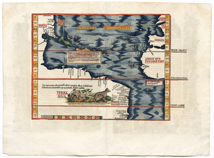
[Oceani occidentalis seu terrae novae tabula]
Print $20.00
- Digital $50.00
[Oceani occidentalis seu terrae novae tabula]
1535
Size: 16.0 x 21.6 inches
95835
A General Map of the Roman Empire Shewing the Situation of all its Provinces & ye Seats of ye Barbarous Nations on their Frontiers

Print $20.00
- Digital $50.00
A General Map of the Roman Empire Shewing the Situation of all its Provinces & ye Seats of ye Barbarous Nations on their Frontiers
1744
Size: 10.8 x 20.5 inches
96644
Lands of the Eastern Mediterranean
Lands of the Eastern Mediterranean
1959
-
Size
25.5 x 19.5 inches
-
Map/Doc
92383
-
Creation Date
1959
Map of Africa engraved to illustrate Mitchell's school and family geography (Inset 1: Map of Egypt / Inset 2: Map of Liberia)
Print $20.00
- Digital $50.00
Map of Africa engraved to illustrate Mitchell's school and family geography (Inset 1: Map of Egypt / Inset 2: Map of Liberia)
1839
-
Size
9.5 x 11.8 inches
-
Map/Doc
93507
-
Creation Date
1839
Eastern Hemisphere
Print $20.00
- Digital $50.00
Eastern Hemisphere
1885
-
Size
12.2 x 9.0 inches
-
Map/Doc
93511
-
Creation Date
1885
Map of Africa engraved to illustrate Mitchell's new intermediate geography (Inset 1: Map of Egypt / Inset 2: Liberia and Sierra Leone)
Print $20.00
- Digital $50.00
Map of Africa engraved to illustrate Mitchell's new intermediate geography (Inset 1: Map of Egypt / Inset 2: Liberia and Sierra Leone)
1885
-
Size
9.0 x 12.2 inches
-
Map/Doc
93530
-
Creation Date
1885
Map of Africa (Inset: Liberia and Sierra Leone)
Print $20.00
- Digital $50.00
Map of Africa (Inset: Liberia and Sierra Leone)
1844
-
Size
9.5 x 12.1 inches
-
Map/Doc
93549
-
Creation Date
1844
Tabula Terre Nove
Print $20.00
- Digital $50.00
Tabula Terre Nove
1513
-
Size
18.7 x 24.6 inches
-
Map/Doc
93800
-
Creation Date
1513
Terre Nove

Print $20.00
- Digital $50.00
Terre Nove
1522
-
Size
13.2 x 18.5 inches
-
Map/Doc
93801
-
Creation Date
1522
Terre Nove (verso)
Print $20.00
- Digital $50.00
Terre Nove (verso)
1522
-
Size
12.2 x 7.8 inches
-
Map/Doc
93802
-
Creation Date
1522
Carte Nouvelle de la Mer du Sud
Print $20.00
- Digital $50.00
Carte Nouvelle de la Mer du Sud
1730
-
Size
25.8 x 39.6 inches
-
Map/Doc
93824
-
Creation Date
1730
Map of Africa designed to accompany Smith's Geography for Schools
Print $20.00
- Digital $50.00
Map of Africa designed to accompany Smith's Geography for Schools
1850
-
Size
9.7 x 12.0 inches
-
Map/Doc
93897
-
Creation Date
1850
Ile de la Réunion, Colonie Française (Océan indien)
Print $20.00
- Digital $50.00
Ile de la Réunion, Colonie Française (Océan indien)
-
Size
14.5 x 20.5 inches
-
Map/Doc
94451
A New Map, or Chart in Mercators Projection, of the Western or Atlantic Ocean, with part of Europe, Africa and America
Print $20.00
- Digital $50.00
A New Map, or Chart in Mercators Projection, of the Western or Atlantic Ocean, with part of Europe, Africa and America
1781
-
Size
17.3 x 21.7 inches
-
Map/Doc
95368
-
Creation Date
1781
[Oceani occidentalis seu terrae novae tabula]
Print $20.00
- Digital $50.00
[Oceani occidentalis seu terrae novae tabula]
1535
-
Size
16.0 x 21.6 inches
-
Map/Doc
95835
-
Creation Date
1535
A General Map of the Roman Empire Shewing the Situation of all its Provinces & ye Seats of ye Barbarous Nations on their Frontiers
Print $20.00
- Digital $50.00
A General Map of the Roman Empire Shewing the Situation of all its Provinces & ye Seats of ye Barbarous Nations on their Frontiers
1744
-
Size
10.8 x 20.5 inches
-
Map/Doc
96644
-
Creation Date
1744
Karte von Afrika

Print $20.00
- Digital $50.00
Karte von Afrika
1888
-
Size
28.9 x 35.5 inches
-
Map/Doc
97503
-
Creation Date
1888