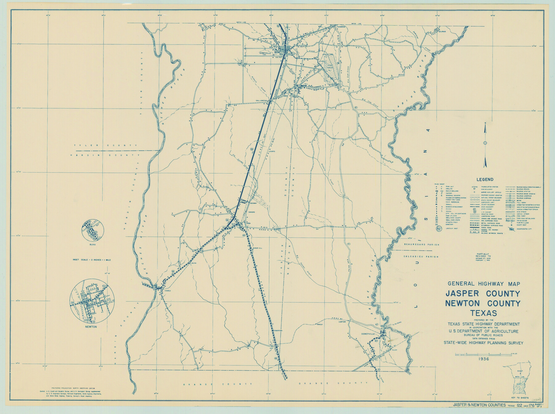
General Highway Map, Jasper County, Newton County, Texas
-
Map/Doc
79141
-
Collection
Texas State Library and Archives
-
Object Dates
1940 (Creation Date)
-
People and Organizations
Texas State Highway Department (Publisher)
-
Counties
Jasper Newton
-
Subjects
County
-
Height x Width
18.6 x 25.0 inches
47.2 x 63.5 cm
-
Comments
Prints available courtesy of the Texas State Library and Archives.
More info can be found here: TSLAC Map 04904
Part of: Texas State Library and Archives
Mexico und Centro-America

Print $20.00
Mexico und Centro-America
1841
Size 14.1 x 17.1 inches
Map/Doc 79732
General Highway Map. Detail of Cities and Towns in Travis County, Texas. City Map, Austin and vicinity, Travis County, Texas

Print $20.00
General Highway Map. Detail of Cities and Towns in Travis County, Texas. City Map, Austin and vicinity, Travis County, Texas
1961
Size 18.1 x 24.7 inches
Map/Doc 79687
General Highway Map, Brown County, Texas

Print $20.00
General Highway Map, Brown County, Texas
1940
Size 25.0 x 18.4 inches
Map/Doc 79031
General Highway Map, Waller County, Texas

Print $20.00
General Highway Map, Waller County, Texas
1939
Size 25.1 x 18.5 inches
Map/Doc 79270
General Highway Map, Howard County, Texas

Print $20.00
General Highway Map, Howard County, Texas
1961
Size 18.1 x 24.6 inches
Map/Doc 79526
General Highway Map, Bexar County, Texas

Print $20.00
General Highway Map, Bexar County, Texas
1961
Size 18.3 x 25.0 inches
Map/Doc 79371
General Highway Map, Hansford County, Texas

Print $20.00
General Highway Map, Hansford County, Texas
1940
Size 18.4 x 25.0 inches
Map/Doc 79112
General Highway Map, Roberts County, Texas

Print $20.00
General Highway Map, Roberts County, Texas
1940
Size 18.4 x 25.0 inches
Map/Doc 79229
General Highway Map, Hardin County, Texas

Print $20.00
General Highway Map, Hardin County, Texas
1940
Size 18.4 x 24.8 inches
Map/Doc 79114
General Highway Map, Fort Bend County, Texas

Print $20.00
General Highway Map, Fort Bend County, Texas
1939
Size 18.6 x 25.2 inches
Map/Doc 79093
Correct Map of the Railway and Steamship Lines operated by the Southern Pacific Company

Print $20.00
Correct Map of the Railway and Steamship Lines operated by the Southern Pacific Company
1894
Size 17.0 x 40.1 inches
Map/Doc 79333
General Highway Map, Pecos County, Texas

Print $20.00
General Highway Map, Pecos County, Texas
1940
Size 24.7 x 18.1 inches
Map/Doc 79218
You may also like
Flight Mission No. BQR-14K, Frame 35, Brazoria County

Print $20.00
- Digital $50.00
Flight Mission No. BQR-14K, Frame 35, Brazoria County
1952
Size 18.5 x 22.2 inches
Map/Doc 84092
Drum, Oyster and Bastrop Bays and Vicinity; Brazoria County, showing Subdivision for Mineral Development

Print $20.00
- Digital $50.00
Drum, Oyster and Bastrop Bays and Vicinity; Brazoria County, showing Subdivision for Mineral Development
1949
Size 35.4 x 45.4 inches
Map/Doc 1908
Township No. 4 South Range No. 16 West of the Indian Meridian

Print $20.00
- Digital $50.00
Township No. 4 South Range No. 16 West of the Indian Meridian
1875
Size 19.4 x 24.4 inches
Map/Doc 75165
Bastrop County

Print $20.00
- Digital $50.00
Bastrop County
1872
Size 21.1 x 17.4 inches
Map/Doc 3279
Starr County Sketch File 52

Print $4.00
- Digital $50.00
Starr County Sketch File 52
Size 13.9 x 9.0 inches
Map/Doc 37011
Jefferson County Sketch File 8a

Print $42.00
- Digital $50.00
Jefferson County Sketch File 8a
Size 8.6 x 7.8 inches
Map/Doc 28120

Austin County Boundary File 5a

Print $6.00
- Digital $50.00
Austin County Boundary File 5a
Size 14.1 x 8.7 inches
Map/Doc 50252
Dawson County Sketch [showing T. & P. Blocks 34 and 33, Township 5 N]
![90546, Dawson County Sketch [showing T. & P. Blocks 34 and 33, Township 5 N], Twichell Survey Records](https://historictexasmaps.com/wmedia_w700/maps/90546-1.tif.jpg)
Print $2.00
- Digital $50.00
Dawson County Sketch [showing T. & P. Blocks 34 and 33, Township 5 N]
Size 12.6 x 7.0 inches
Map/Doc 90546
Flight Mission No. DQN-2K, Frame 5, Calhoun County

Print $20.00
- Digital $50.00
Flight Mission No. DQN-2K, Frame 5, Calhoun County
1953
Size 18.5 x 22.2 inches
Map/Doc 84222
Galveston, Harrisburg & San Antonio Railway, Map of Eagle Pass Branch

Print $20.00
- Digital $50.00
Galveston, Harrisburg & San Antonio Railway, Map of Eagle Pass Branch
1888
Size 42.7 x 25.8 inches
Map/Doc 64462
Sketch showing recent surveys of State School Land adjoining Capitol Leagues No. 357 1/2, 367, 373 and 374 corrected out of conflict

Print $2.00
- Digital $50.00
Sketch showing recent surveys of State School Land adjoining Capitol Leagues No. 357 1/2, 367, 373 and 374 corrected out of conflict
1905
Size 7.3 x 10.4 inches
Map/Doc 90535