General Road Map, Webb County, Texas

Print $40.00
- Digital $50.00
General Road Map, Webb County, Texas
1944
Size: 37.1 x 50.0 inches
10126
Map of Clay County, Cooke Land District, formely(sic.) Fannin Land District

Print $20.00
- Digital $50.00
Map of Clay County, Cooke Land District, formely(sic.) Fannin Land District
1859
Size: 30.2 x 19.0 inches
1049
Capitol Land Reservation

Print $20.00
- Digital $50.00
Capitol Land Reservation
1880
Size: 43.7 x 34.2 inches
10745
Capitol Land Reservation

Print $20.00
- Digital $50.00
Capitol Land Reservation
1880
Size: 27.1 x 34.4 inches
10746
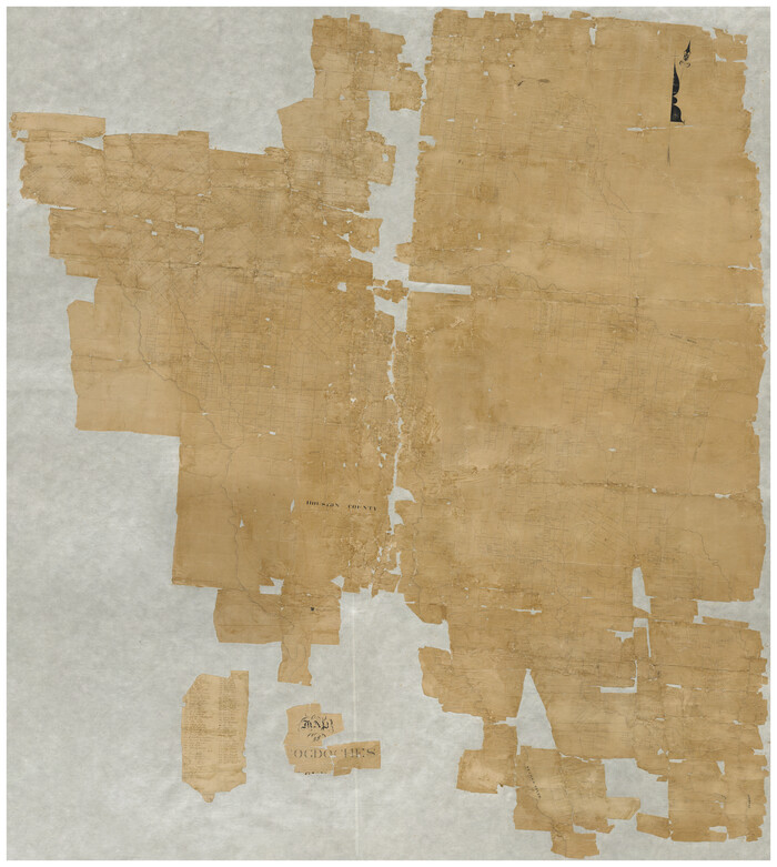
[Map of Nacogdoches County]
Print $40.00
- Digital $50.00
[Map of Nacogdoches County]
1840
Size: 79.3 x 69.8 inches
10784
Capitol Land Reservation

Print $40.00
- Digital $50.00
Capitol Land Reservation
1880
Size: 115.6 x 36.6 inches
10785
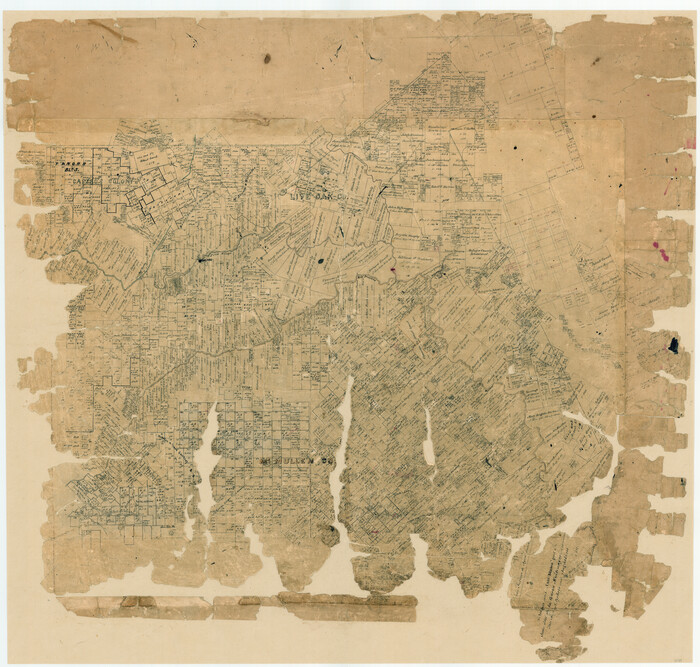
[McMullen and Live Oak County]
Print $20.00
- Digital $50.00
[McMullen and Live Oak County]
1870
Size: 34.3 x 36.0 inches
10789
Montgomery County

Print $20.00
- Digital $50.00
Montgomery County
1901
Size: 42.8 x 45.9 inches
10794
Map of Motley County

Print $20.00
- Digital $50.00
Map of Motley County
1902
Size: 43.4 x 37.7 inches
10799
Map of Collin County

Print $20.00
- Digital $50.00
Map of Collin County
1862
Size: 24.4 x 20.5 inches
1084
Map of Grayson County

Print $20.00
- Digital $50.00
Map of Grayson County
1871
Size: 19.5 x 17.8 inches
1088
Map of Harrison County

Print $20.00
- Digital $50.00
Map of Harrison County
1871
Size: 18.0 x 19.1 inches
1117
Map of Harrison County

Print $20.00
- Digital $50.00
Map of Harrison County
1880
Size: 20.4 x 21.8 inches
1119
Map of Denton County

Print $20.00
- Digital $50.00
Map of Denton County
1896
Size: 25.6 x 22.0 inches
11311
Guadalupe County Sketch File 23

Print $22.00
- Digital $50.00
Guadalupe County Sketch File 23
1859
Size: 25.5 x 19.0 inches
11592
Harris County Texas

Print $20.00
- Digital $50.00
Harris County Texas
1908
Size: 19.7 x 24.7 inches
11652
Milam County Sketch File 8

Print $20.00
- Digital $50.00
Milam County Sketch File 8
1856
Size: 16.8 x 33.7 inches
12091
General Road Map, Webb County, Texas
Print $40.00
- Digital $50.00
General Road Map, Webb County, Texas
1944
-
Size
37.1 x 50.0 inches
-
Map/Doc
10126
-
Creation Date
1944
Map of Brazoria

Print $20.00
- Digital $50.00
Map of Brazoria
1863
-
Size
27.4 x 27.3 inches
-
Map/Doc
1013
-
Creation Date
1863
Map of Clay County, Cooke Land District, formely(sic.) Fannin Land District
Print $20.00
- Digital $50.00
Map of Clay County, Cooke Land District, formely(sic.) Fannin Land District
1859
-
Size
30.2 x 19.0 inches
-
Map/Doc
1049
-
Creation Date
1859
Capitol Land Reservation
Print $20.00
- Digital $50.00
Capitol Land Reservation
1880
-
Size
43.7 x 34.2 inches
-
Map/Doc
10745
-
Creation Date
1880
Capitol Land Reservation
Print $20.00
- Digital $50.00
Capitol Land Reservation
1880
-
Size
27.1 x 34.4 inches
-
Map/Doc
10746
-
Creation Date
1880
[Map of Nacogdoches County]
Print $40.00
- Digital $50.00
[Map of Nacogdoches County]
1840
-
Size
79.3 x 69.8 inches
-
Map/Doc
10784
-
Creation Date
1840
Capitol Land Reservation
Print $40.00
- Digital $50.00
Capitol Land Reservation
1880
-
Size
115.6 x 36.6 inches
-
Map/Doc
10785
-
Creation Date
1880
Nacogdoches Co.

Print $40.00
- Digital $50.00
Nacogdoches Co.
1905
-
Size
50.7 x 42.0 inches
-
Map/Doc
10787
-
Creation Date
1905
McMullen County

Print $40.00
- Digital $50.00
McMullen County
1918
-
Size
49.5 x 35.9 inches
-
Map/Doc
10788
-
Creation Date
1918
[McMullen and Live Oak County]
Print $20.00
- Digital $50.00
[McMullen and Live Oak County]
1870
-
Size
34.3 x 36.0 inches
-
Map/Doc
10789
-
Creation Date
1870
Medina County

Print $40.00
- Digital $50.00
Medina County
1915
-
Size
53.2 x 44.8 inches
-
Map/Doc
10790
-
Creation Date
1915
Mills Co.

Print $20.00
- Digital $50.00
Mills Co.
1906
-
Size
38.4 x 46.4 inches
-
Map/Doc
10791
-
Creation Date
1906
Mitchell County

Print $20.00
- Digital $50.00
Mitchell County
1889
-
Size
42.3 x 35.7 inches
-
Map/Doc
10792
-
Creation Date
1889
Montague Co.

Print $20.00
- Digital $50.00
Montague Co.
1886
-
Size
43.1 x 32.9 inches
-
Map/Doc
10793
-
Creation Date
1886
Montgomery County
Print $20.00
- Digital $50.00
Montgomery County
1901
-
Size
42.8 x 45.9 inches
-
Map/Doc
10794
-
Creation Date
1901
Moore Co.

Print $20.00
- Digital $50.00
Moore Co.
1902
-
Size
43.4 x 37.1 inches
-
Map/Doc
10795
-
Creation Date
1902
Motley Co.

Print $40.00
- Digital $50.00
Motley Co.
1893
-
Size
49.5 x 37.8 inches
-
Map/Doc
10796
-
Creation Date
1893
Motley County

Print $20.00
- Digital $50.00
Motley County
1914
-
Size
47.7 x 37.4 inches
-
Map/Doc
10797
-
Creation Date
1914
Motley Co.

Print $20.00
- Digital $50.00
Motley Co.
1893
-
Size
40.9 x 32.9 inches
-
Map/Doc
10798
-
Creation Date
1893
Map of Motley County
Print $20.00
- Digital $50.00
Map of Motley County
1902
-
Size
43.4 x 37.7 inches
-
Map/Doc
10799
-
Creation Date
1902
Map of Collin County
Print $20.00
- Digital $50.00
Map of Collin County
1862
-
Size
24.4 x 20.5 inches
-
Map/Doc
1084
-
Creation Date
1862
Map of Grayson County
Print $20.00
- Digital $50.00
Map of Grayson County
1871
-
Size
19.5 x 17.8 inches
-
Map/Doc
1088
-
Creation Date
1871
Harrison County

Print $20.00
- Digital $50.00
Harrison County
1857
-
Size
20.3 x 21.0 inches
-
Map/Doc
1116
-
Creation Date
1857
Map of Harrison County
Print $20.00
- Digital $50.00
Map of Harrison County
1871
-
Size
18.0 x 19.1 inches
-
Map/Doc
1117
-
Creation Date
1871
Map of Harrison County
Print $20.00
- Digital $50.00
Map of Harrison County
1880
-
Size
20.4 x 21.8 inches
-
Map/Doc
1119
-
Creation Date
1880
Haskell County

Print $20.00
- Digital $50.00
Haskell County
1879
-
Size
21.0 x 20.4 inches
-
Map/Doc
1127
-
Creation Date
1879
Map of Denton County
Print $20.00
- Digital $50.00
Map of Denton County
1896
-
Size
25.6 x 22.0 inches
-
Map/Doc
11311
-
Creation Date
1896
Guadalupe County Sketch File 23
Print $22.00
- Digital $50.00
Guadalupe County Sketch File 23
1859
-
Size
25.5 x 19.0 inches
-
Map/Doc
11592
-
Creation Date
1859
Harris County Texas
Print $20.00
- Digital $50.00
Harris County Texas
1908
-
Size
19.7 x 24.7 inches
-
Map/Doc
11652
-
Creation Date
1908
Milam County Sketch File 8
Print $20.00
- Digital $50.00
Milam County Sketch File 8
1856
-
Size
16.8 x 33.7 inches
-
Map/Doc
12091
-
Creation Date
1856