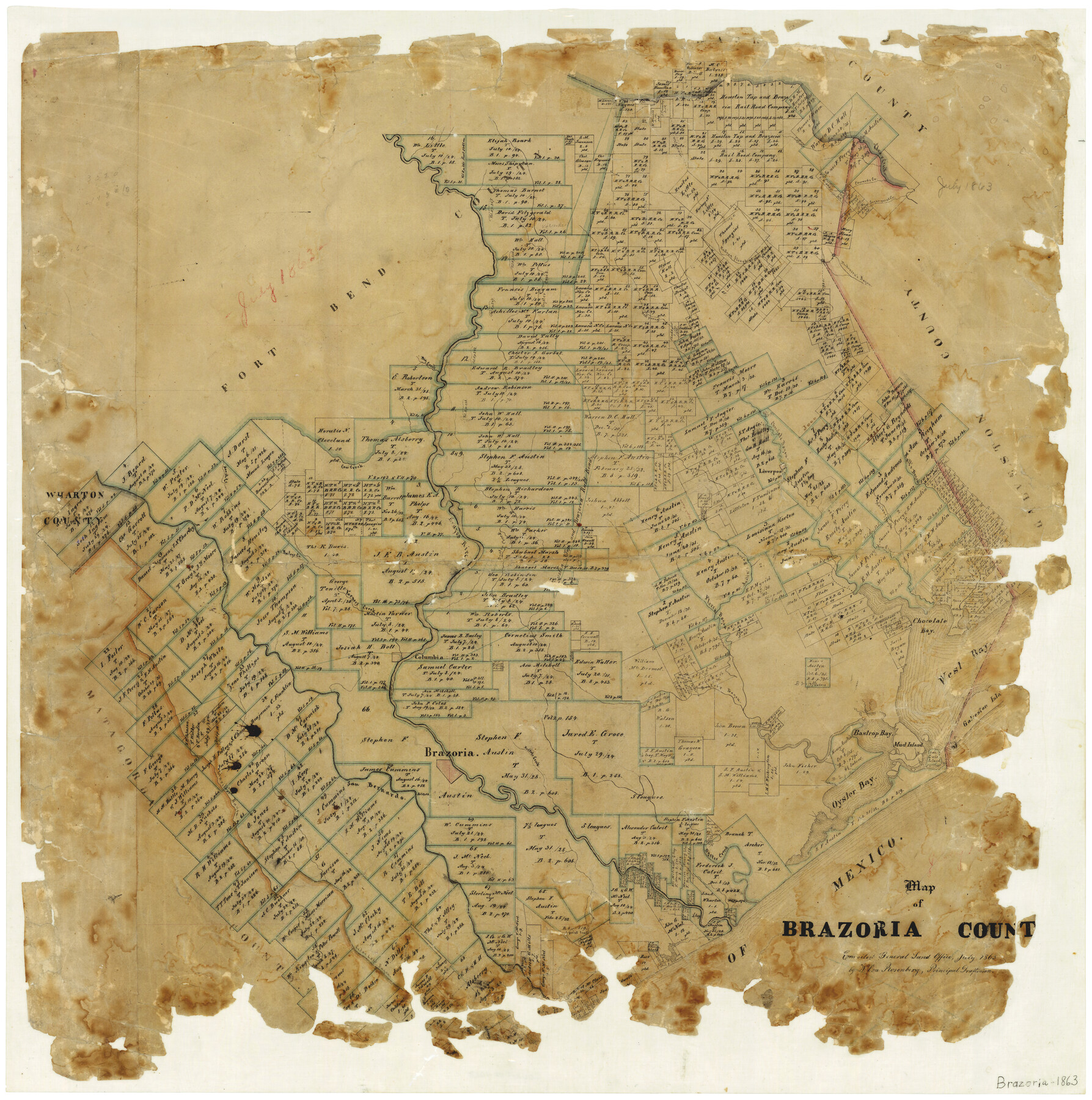
Map of Brazoria
-
Map/Doc
1013
-
Collection
General Map Collection
-
Object Dates
1863 (Creation Date)
-
People and Organizations
Texas General Land Office (Publisher)
W. von Rosenberg (Compiler)
-
Counties
Brazoria
-
Subjects
County
-
Height x Width
27.4 x 27.3 inches
69.6 x 69.3 cm
-
Features
Flores Bayou
Cedar Lake Bayou
Gulf of Mexico
Williamson Bayou
Oyster Creek
San Luis Island
Mud Island
Oyster Bay
Buffalo Creek
Brazoria
San Bernardo River
Linvill's Bayou
Columbia
Galveston Island
West Bay
Chocolate Bay
Clear Creek
Varners Creek
Bailey's Creek
Brazos River
Austin's Bayou
New Creek
Hall's Bayou
Liverpool
HT&B
Cow Creek
Mount Creek
Dickenson's [sic] Bayou
Mustang Slough
Oyster Creek
Sugarpoint Creek
Coward's Creek
Part of: General Map Collection
McMullen County Working Sketch 37

Print $20.00
- Digital $50.00
McMullen County Working Sketch 37
1969
Size 37.4 x 38.4 inches
Map/Doc 70738
Flight Mission No. CUG-3P, Frame 133, Kleberg County

Print $20.00
- Digital $50.00
Flight Mission No. CUG-3P, Frame 133, Kleberg County
1956
Size 18.7 x 22.2 inches
Map/Doc 86268
Bastrop County Boundary File 3

Print $48.00
- Digital $50.00
Bastrop County Boundary File 3
1925
Size 11.3 x 8.7 inches
Map/Doc 50320
Right of Way and Track Map, International & Gt. Northern Ry. Operated by the International & Gt. Northern Ry. Co., Gulf Division

Print $40.00
- Digital $50.00
Right of Way and Track Map, International & Gt. Northern Ry. Operated by the International & Gt. Northern Ry. Co., Gulf Division
1917
Size 24.8 x 57.0 inches
Map/Doc 64245
Ward County Working Sketch 32

Print $40.00
- Digital $50.00
Ward County Working Sketch 32
1967
Size 32.5 x 66.0 inches
Map/Doc 72338
Flight Mission No. CLL-1N, Frame 29, Willacy County

Print $20.00
- Digital $50.00
Flight Mission No. CLL-1N, Frame 29, Willacy County
1954
Size 18.5 x 22.1 inches
Map/Doc 87010
Culberson County Working Sketch 85

Print $20.00
- Digital $50.00
Culberson County Working Sketch 85
1981
Size 37.0 x 36.9 inches
Map/Doc 68539
Kerr County Boundary File 1

Print $4.00
- Digital $50.00
Kerr County Boundary File 1
Size 12.7 x 8.1 inches
Map/Doc 55982
Williamson County Sketch File 4

Print $26.00
- Digital $50.00
Williamson County Sketch File 4
1849
Size 15.9 x 10.4 inches
Map/Doc 40304
Flight Mission No. CRE-3R, Frame 39, Jackson County

Print $20.00
- Digital $50.00
Flight Mission No. CRE-3R, Frame 39, Jackson County
1956
Size 18.6 x 22.2 inches
Map/Doc 85386
Gregg County Rolled Sketch 24

Print $40.00
- Digital $50.00
Gregg County Rolled Sketch 24
Size 40.0 x 49.7 inches
Map/Doc 9075
Dallas County Working Sketch 16

Print $20.00
- Digital $50.00
Dallas County Working Sketch 16
1981
Size 15.7 x 12.0 inches
Map/Doc 68582
You may also like
Upton County Sketch File 26

Print $20.00
- Digital $50.00
Upton County Sketch File 26
1928
Size 22.6 x 14.2 inches
Map/Doc 12520
Galveston County Sketch File 57

Print $8.00
- Digital $50.00
Galveston County Sketch File 57
1910
Size 8.1 x 5.2 inches
Map/Doc 23603
Cherokee County Sketch File 22b

Print $20.00
- Digital $50.00
Cherokee County Sketch File 22b
1906
Size 15.5 x 14.0 inches
Map/Doc 82019
Webb County Working Sketch 11

Print $20.00
- Digital $50.00
Webb County Working Sketch 11
1921
Size 17.8 x 16.3 inches
Map/Doc 72376
Hall County Rolled Sketch 9

Print $20.00
- Digital $50.00
Hall County Rolled Sketch 9
1946
Size 22.0 x 40.4 inches
Map/Doc 6053
King County Sketch File 8

Print $46.00
- Digital $50.00
King County Sketch File 8
Size 8.8 x 8.9 inches
Map/Doc 29060
Wharton County Working Sketch 9

Print $3.00
- Digital $50.00
Wharton County Working Sketch 9
1982
Size 12.4 x 10.4 inches
Map/Doc 72473
Johnson County Boundary File 51a

Print $66.00
- Digital $50.00
Johnson County Boundary File 51a
Size 12.7 x 8.2 inches
Map/Doc 55604
[Worksheets related to the Wilson Strickland survey and vicinity]
![91381, [Worksheets related to the Wilson Strickland survey and vicinity], Twichell Survey Records](https://historictexasmaps.com/wmedia_w700/maps/91381-1.tif.jpg)
Print $20.00
- Digital $50.00
[Worksheets related to the Wilson Strickland survey and vicinity]
Size 20.1 x 24.8 inches
Map/Doc 91381
Winkler County Working Sketch 18

Print $40.00
- Digital $50.00
Winkler County Working Sketch 18
1980
Size 33.7 x 49.9 inches
Map/Doc 72612
[West Part of Labor 18]
![91006, [West Part of Labor 18], Twichell Survey Records](https://historictexasmaps.com/wmedia_w700/maps/91006-1.tif.jpg)
Print $20.00
- Digital $50.00
[West Part of Labor 18]
Size 18.9 x 19.4 inches
Map/Doc 91006
Harris County Rolled Sketch 28(1)

Print $39.00
- Digital $50.00
Harris County Rolled Sketch 28(1)
Size 10.0 x 15.3 inches
Map/Doc 45770