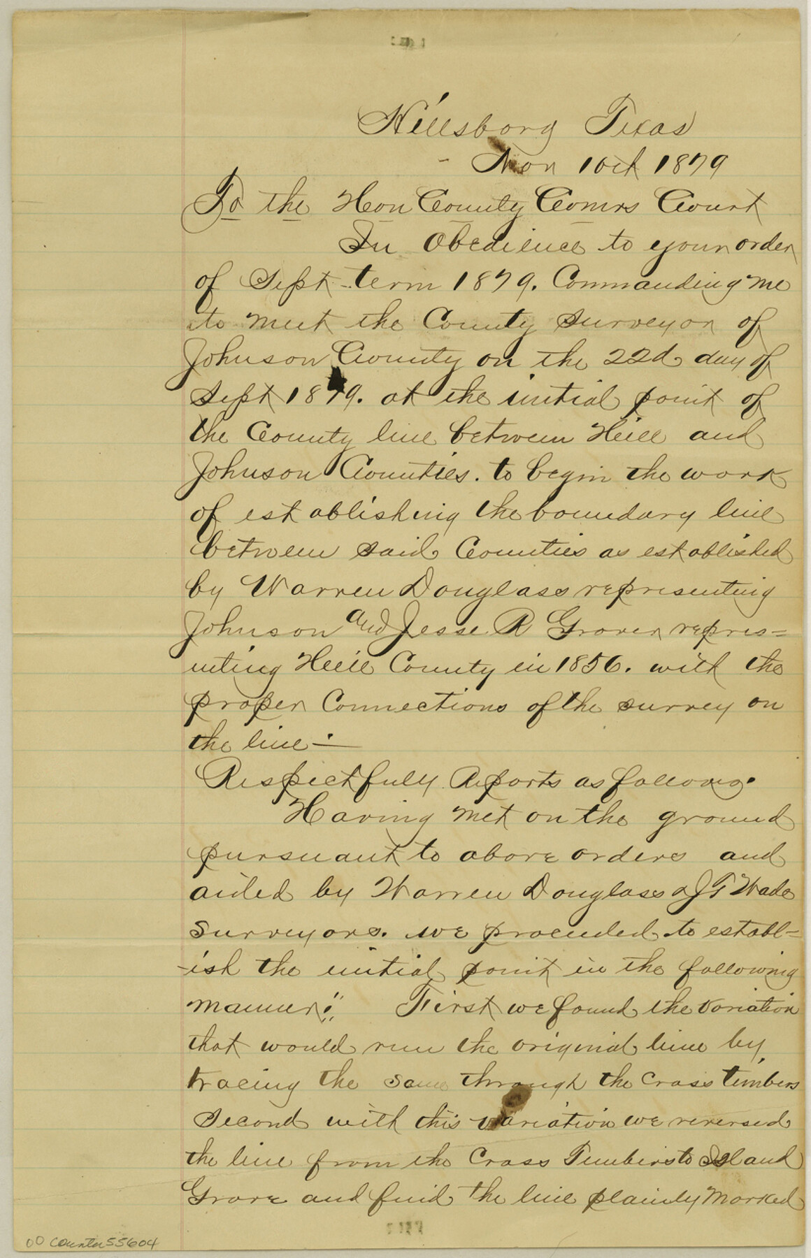
Johnson County Boundary File 51a
Field notes and plat of Co. line between Hill and Johnson Counties
-
Map/Doc
55604
-
Collection
General Map Collection
-
Counties
Johnson
-
Subjects
County Boundaries
-
Height x Width
12.7 x 8.2 inches
32.3 x 20.8 cm
Part of: General Map Collection
Cooke County Working Sketch 37

Print $20.00
- Digital $50.00
Cooke County Working Sketch 37
1995
Size 21.7 x 18.9 inches
Map/Doc 68274
Kimble County Working Sketch 45

Print $20.00
- Digital $50.00
Kimble County Working Sketch 45
1950
Size 26.4 x 28.5 inches
Map/Doc 70113
Van Zandt County Sketch File 10

Print $4.00
- Digital $50.00
Van Zandt County Sketch File 10
1858
Size 6.2 x 8.0 inches
Map/Doc 39395
San Patricio County Rolled Sketch 46H

Print $4.00
- Digital $50.00
San Patricio County Rolled Sketch 46H
1983
Size 12.1 x 18.4 inches
Map/Doc 8379
Gregg County Working Sketch 7

Print $20.00
- Digital $50.00
Gregg County Working Sketch 7
1934
Size 32.2 x 21.0 inches
Map/Doc 63273
Andrews County Sketch File 9

Print $8.00
- Digital $50.00
Andrews County Sketch File 9
1949
Size 14.2 x 8.6 inches
Map/Doc 12853
Atascosa County Sketch File 3b

Print $8.00
- Digital $50.00
Atascosa County Sketch File 3b
1857
Size 11.4 x 5.8 inches
Map/Doc 13739
Williamson County

Print $40.00
- Digital $50.00
Williamson County
1946
Size 38.7 x 56.8 inches
Map/Doc 95676
Crockett County Rolled Sketch 80

Print $40.00
- Digital $50.00
Crockett County Rolled Sketch 80
1954
Size 24.8 x 55.5 inches
Map/Doc 8725
Webb County Sketch File 14b

Print $4.00
- Digital $50.00
Webb County Sketch File 14b
1897
Size 11.2 x 8.8 inches
Map/Doc 39812
Yoakum County Rolled Sketch 6

Print $20.00
- Digital $50.00
Yoakum County Rolled Sketch 6
Size 18.7 x 34.6 inches
Map/Doc 8291
Gregg County Boundary File 1

Print $6.00
- Digital $50.00
Gregg County Boundary File 1
Size 10.0 x 7.9 inches
Map/Doc 53981
You may also like
Flight Mission No. DAH-17M, Frame 62, Orange County

Print $20.00
- Digital $50.00
Flight Mission No. DAH-17M, Frame 62, Orange County
1953
Size 18.5 x 22.6 inches
Map/Doc 86896
![94190, California [Recto], General Map Collection](https://historictexasmaps.com/wmedia_w700/maps/94190.tif.jpg)
Property Line Map, Public Housing Authority

Print $3.00
- Digital $50.00
Property Line Map, Public Housing Authority
Size 11.9 x 15.5 inches
Map/Doc 92707
[W. S. Mabry's maps in south part of Oldham County]
![93065, [W. S. Mabry's maps in south part of Oldham County], Twichell Survey Records](https://historictexasmaps.com/wmedia_w700/maps/93065-1.tif.jpg)
Print $20.00
- Digital $50.00
[W. S. Mabry's maps in south part of Oldham County]
Size 40.4 x 15.8 inches
Map/Doc 93065

Red River County Sketch File 5

Print $4.00
- Digital $50.00
Red River County Sketch File 5
Size 7.9 x 4.8 inches
Map/Doc 35102
Flight Mission No. DIX-5P, Frame 149, Aransas County

Print $20.00
- Digital $50.00
Flight Mission No. DIX-5P, Frame 149, Aransas County
1956
Size 17.8 x 17.8 inches
Map/Doc 83811
Brewster County Rolled Sketch 101

Print $40.00
- Digital $50.00
Brewster County Rolled Sketch 101
1927
Size 55.0 x 40.0 inches
Map/Doc 8509
Kerr County Sketch File 15

Print $20.00
- Digital $50.00
Kerr County Sketch File 15
Size 23.7 x 16.8 inches
Map/Doc 11919
Bastrop County Rolled Sketch 4

Print $40.00
- Digital $50.00
Bastrop County Rolled Sketch 4
1999
Size 130.2 x 30.8 inches
Map/Doc 8443
Polk County Sketch File 23

Print $20.00
- Digital $50.00
Polk County Sketch File 23
Size 18.0 x 18.6 inches
Map/Doc 12191
Triangulation Net of the United States

Print $20.00
- Digital $50.00
Triangulation Net of the United States
1938
Size 28.1 x 42.2 inches
Map/Doc 3117