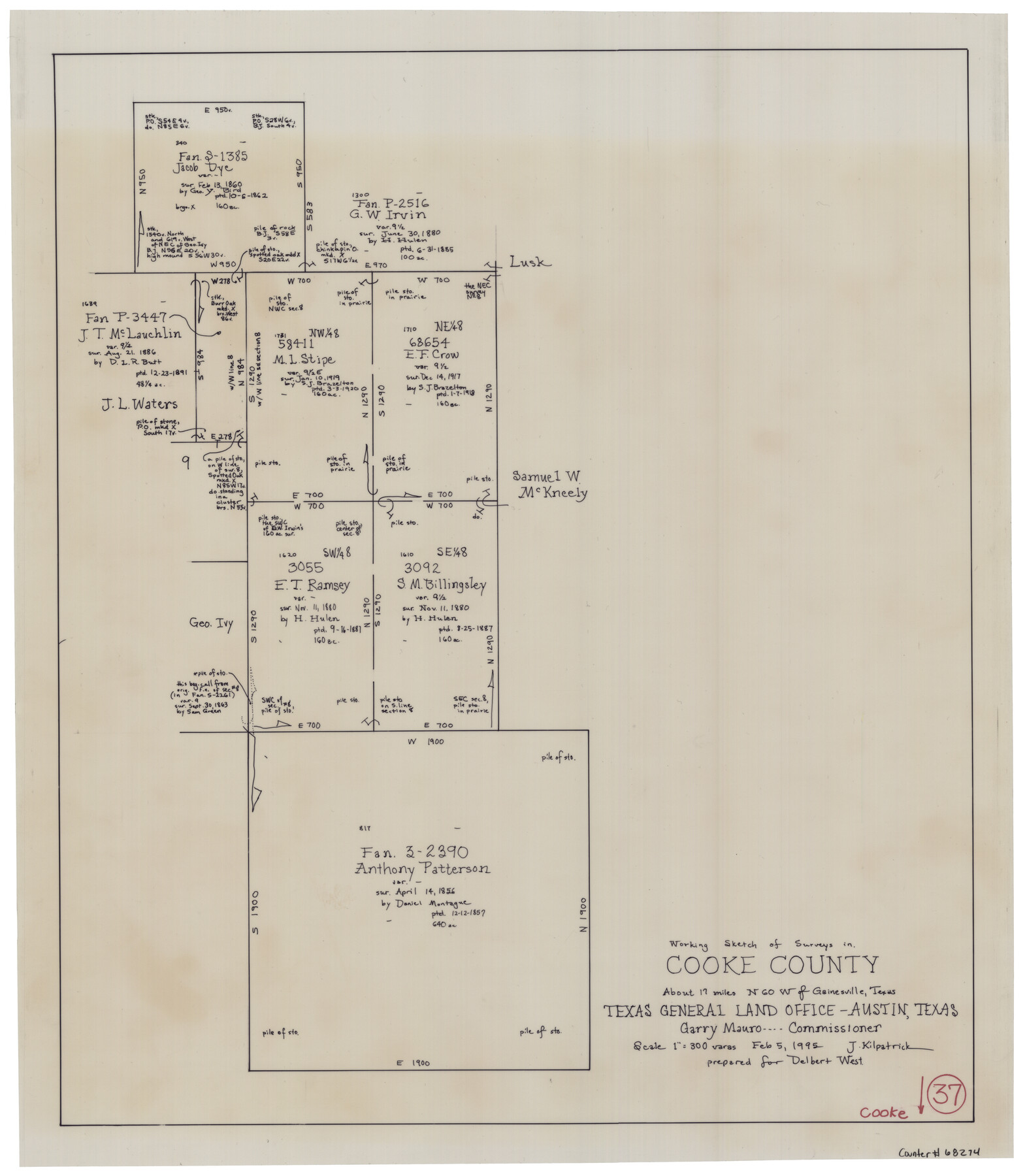
Cooke County Working Sketch 37
-
Map/Doc
68274
-
Collection
General Map Collection
-
Object Dates
2/5/1995 (Creation Date)
-
People and Organizations
Joan Kilpatrick (Draftsman)
-
Counties
Cooke
-
Subjects
Surveying Working Sketch
-
Height x Width
21.7 x 18.9 inches
55.1 x 48.0 cm
-
Scale
1" = 300 varas
Part of: General Map Collection

Jackson County Working Sketch 2

Print $20.00
- Digital $50.00
Jackson County Working Sketch 2
1937
Size 41.5 x 38.0 inches
Map/Doc 66450
Wichita County Rolled Sketch 7

Print $20.00
- Digital $50.00
Wichita County Rolled Sketch 7
Size 14.7 x 16.4 inches
Map/Doc 8244
Brazoria County NRC Article 33.136 Sketch 32

Print $24.00
Brazoria County NRC Article 33.136 Sketch 32
2025
Map/Doc 97490
Polk County Working Sketch 4

Print $20.00
- Digital $50.00
Polk County Working Sketch 4
1925
Size 46.3 x 42.6 inches
Map/Doc 71619
McMullen County Sketch File 5

Print $4.00
- Digital $50.00
McMullen County Sketch File 5
1854
Size 8.7 x 8.3 inches
Map/Doc 31343
Loving County Rolled Sketch 15

Print $20.00
- Digital $50.00
Loving County Rolled Sketch 15
2015
Size 36.2 x 24.4 inches
Map/Doc 93793
Rio Grande, Laguna Atascosa Sheet

Print $20.00
- Digital $50.00
Rio Grande, Laguna Atascosa Sheet
1935
Size 37.4 x 37.6 inches
Map/Doc 65112
Concho County Sketch File 37

Print $20.00
- Digital $50.00
Concho County Sketch File 37
1938
Size 18.7 x 29.1 inches
Map/Doc 11162
Knox County Rolled Sketch 16

Print $20.00
- Digital $50.00
Knox County Rolled Sketch 16
1892
Size 29.8 x 32.4 inches
Map/Doc 76029
Hockley County Sketch File 19

Print $20.00
- Digital $50.00
Hockley County Sketch File 19
1944
Size 14.9 x 25.8 inches
Map/Doc 11775
Midland County Sketch File 1

Print $20.00
- Digital $50.00
Midland County Sketch File 1
1886
Size 25.7 x 16.1 inches
Map/Doc 12079
You may also like
[Surveys along Sims Bayou]
![156, [Surveys along Sims Bayou], General Map Collection](https://historictexasmaps.com/wmedia_w700/maps/156.tif.jpg)
Print $2.00
- Digital $50.00
[Surveys along Sims Bayou]
1842
Size 8.6 x 6.2 inches
Map/Doc 156
Webb County Sketch File 62

Print $6.00
- Digital $50.00
Webb County Sketch File 62
1946
Size 11.5 x 9.0 inches
Map/Doc 39862
[Surveys in the Bexar District along the Atascosa Creek]
![221, [Surveys in the Bexar District along the Atascosa Creek], General Map Collection](https://historictexasmaps.com/wmedia_w700/maps/221.tif.jpg)
Print $2.00
- Digital $50.00
[Surveys in the Bexar District along the Atascosa Creek]
1842
Size 5.9 x 5.9 inches
Map/Doc 221
Coryell County Working Sketch 30

Print $20.00
- Digital $50.00
Coryell County Working Sketch 30
2001
Size 37.1 x 38.7 inches
Map/Doc 68237
Ward County Working Sketch 22

Print $20.00
- Digital $50.00
Ward County Working Sketch 22
1953
Size 19.5 x 20.7 inches
Map/Doc 72328
Flight Mission No. DQN-7K, Frame 15, Calhoun County

Print $20.00
- Digital $50.00
Flight Mission No. DQN-7K, Frame 15, Calhoun County
1953
Size 18.4 x 22.1 inches
Map/Doc 84466
General Highway Map, Refugio County, Texas

Print $20.00
General Highway Map, Refugio County, Texas
1961
Size 18.1 x 24.7 inches
Map/Doc 79639
Mapa Original de Texas por El Ciudadano Estevan F. Austin Presentado al Exmo. Sr. Presidente por su autor 1829

Print $20.00
- Digital $50.00
Mapa Original de Texas por El Ciudadano Estevan F. Austin Presentado al Exmo. Sr. Presidente por su autor 1829
1830
Size 32.3 x 25.3 inches
Map/Doc 2106
Orange County Rolled Sketch CR

Print $20.00
- Digital $50.00
Orange County Rolled Sketch CR
Size 39.4 x 31.5 inches
Map/Doc 9653
[George Gentry, Wm. Williams, and surrounding surveys]
![90973, [George Gentry, Wm. Williams, and surrounding surveys], Twichell Survey Records](https://historictexasmaps.com/wmedia_w700/maps/90973-1.tif.jpg)
Print $2.00
- Digital $50.00
[George Gentry, Wm. Williams, and surrounding surveys]
Size 8.3 x 12.6 inches
Map/Doc 90973
Navigation Maps of Gulf Intracoastal Waterway, Port Arthur to Brownsville, Texas

Print $4.00
- Digital $50.00
Navigation Maps of Gulf Intracoastal Waterway, Port Arthur to Brownsville, Texas
1951
Size 16.6 x 21.5 inches
Map/Doc 65430
The Chief Justice County of Bexar. May 1, 1837

Print $20.00
The Chief Justice County of Bexar. May 1, 1837
2020
Size 25.4 x 21.6 inches
Map/Doc 96038