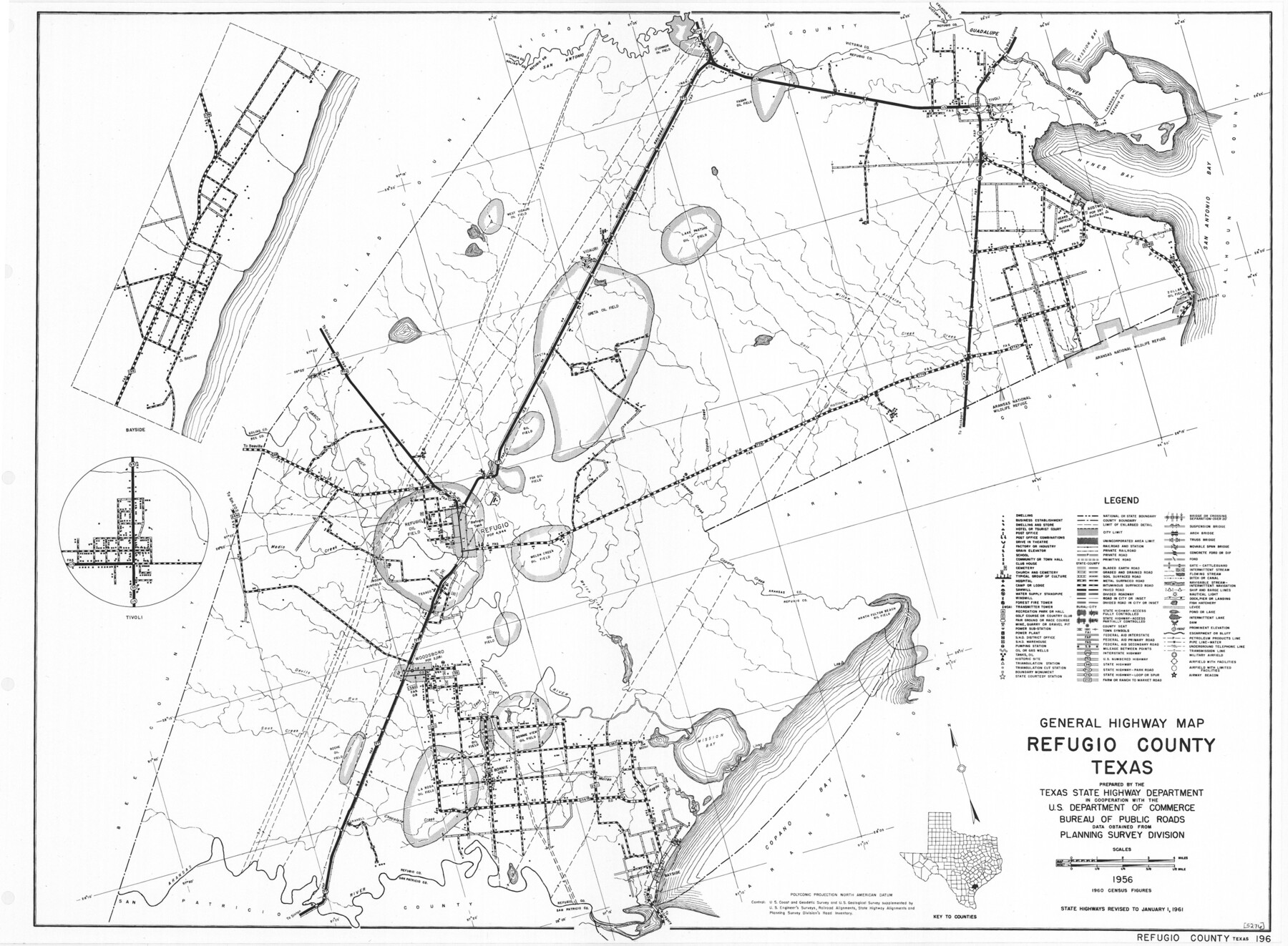
General Highway Map, Refugio County, Texas
-
Map/Doc
79639
-
Collection
Texas State Library and Archives
-
Object Dates
1961 (Creation Date)
-
People and Organizations
Texas State Highway Department (Publisher)
-
Counties
Refugio
-
Subjects
County
-
Height x Width
18.1 x 24.7 inches
46.0 x 62.7 cm
-
Comments
Prints available courtesy of the Texas State Library and Archives.
More info can be found here: TSLAC Map 05276
Part of: Texas State Library and Archives
General Highway Map. Detail of Cities and Towns in Potter County, Texas [Amarillo and vicinity]
![79632, General Highway Map. Detail of Cities and Towns in Potter County, Texas [Amarillo and vicinity], Texas State Library and Archives](https://historictexasmaps.com/wmedia_w700/maps/79632.tif.jpg)
Print $20.00
General Highway Map. Detail of Cities and Towns in Potter County, Texas [Amarillo and vicinity]
1961
Size 24.4 x 18.1 inches
Map/Doc 79632
General Highway Map, Willacy County, Texas

Print $20.00
General Highway Map, Willacy County, Texas
1961
Size 18.2 x 24.7 inches
Map/Doc 79711
General Highway Map, Hood County, Somervell County, Texas

Print $20.00
General Highway Map, Hood County, Somervell County, Texas
1961
Size 18.1 x 24.6 inches
Map/Doc 79523
Map of Texas, compiled from surveys on record in the General Land Office of the Republic

Print $20.00
Map of Texas, compiled from surveys on record in the General Land Office of the Republic
1839
Size 32.0 x 24.9 inches
Map/Doc 76198
Revised Map of Austin, Texas

Print $20.00
Revised Map of Austin, Texas
1885
Size 16.5 x 14.0 inches
Map/Doc 76272
General Highway Map, Yoakum County, Texas

Print $20.00
General Highway Map, Yoakum County, Texas
1940
Size 18.3 x 24.9 inches
Map/Doc 79285
General Highway Map, Karnes County, Texas

Print $20.00
General Highway Map, Karnes County, Texas
1940
Size 18.3 x 24.7 inches
Map/Doc 79151
Karte von Indian Point od Indianola / Karte der Stadt Neu Braunfels / Karte der Stadt Friedrichsburg / Hafen von Indian Point oder Indianola (Carlshafen) [Four map insets]
![79297, Karte von Indian Point od Indianola / Karte der Stadt Neu Braunfels / Karte der Stadt Friedrichsburg / Hafen von Indian Point oder Indianola (Carlshafen) [Four map insets], Texas State Library and Archives](https://historictexasmaps.com/wmedia_w700/maps/79297.tif.jpg)
Print $20.00
Karte von Indian Point od Indianola / Karte der Stadt Neu Braunfels / Karte der Stadt Friedrichsburg / Hafen von Indian Point oder Indianola (Carlshafen) [Four map insets]
1850
Size 13.3 x 19.4 inches
Map/Doc 79297
General Highway Map, Galveston County, Texas

Print $20.00
General Highway Map, Galveston County, Texas
1961
Size 18.2 x 24.6 inches
Map/Doc 79476
General Highway Map, Randall County, Texas

Print $20.00
General Highway Map, Randall County, Texas
1940
Size 18.3 x 25.0 inches
Map/Doc 79224
General Highway Map, Hemphill County, Texas

Print $20.00
General Highway Map, Hemphill County, Texas
1940
Size 18.2 x 24.8 inches
Map/Doc 79124
Map of Texas compiled from surveys recorded in the Land Office of Texas, and other official surveys

Print $20.00
Map of Texas compiled from surveys recorded in the Land Office of Texas, and other official surveys
1841
Size 25.1 x 20.4 inches
Map/Doc 76253
You may also like
Knox County Rolled Sketch 18

Print $20.00
- Digital $50.00
Knox County Rolled Sketch 18
1945
Size 23.1 x 29.5 inches
Map/Doc 6558
Val Verde County

Print $20.00
- Digital $50.00
Val Verde County
1944
Size 42.3 x 37.8 inches
Map/Doc 73311
Current Miscellaneous File 72

Print $40.00
- Digital $50.00
Current Miscellaneous File 72
Size 10.8 x 8.2 inches
Map/Doc 74159
La Salle County Sketch File 24

Print $4.00
- Digital $50.00
La Salle County Sketch File 24
1877
Size 9.2 x 6.1 inches
Map/Doc 29547
Edwards County Working Sketch 83

Print $20.00
- Digital $50.00
Edwards County Working Sketch 83
1965
Size 29.2 x 34.3 inches
Map/Doc 68959
Hidalgo County Sketch File 4

Print $20.00
- Digital $50.00
Hidalgo County Sketch File 4
Size 21.4 x 25.2 inches
Map/Doc 11760
Val Verde County Working Sketch 23

Print $20.00
- Digital $50.00
Val Verde County Working Sketch 23
1932
Size 29.6 x 24.9 inches
Map/Doc 72158
Val Verde County Sketch File 44A

Print $10.00
- Digital $50.00
Val Verde County Sketch File 44A
1940
Size 14.5 x 8.8 inches
Map/Doc 39311
Jasper County Sketch File 10

Print $4.00
- Digital $50.00
Jasper County Sketch File 10
1878
Size 9.1 x 8.6 inches
Map/Doc 27788
[Northwest Garza County around John Walker and Thomas Hughes surveys]
![90848, [Northwest Garza County around John Walker and Thomas Hughes surveys], Twichell Survey Records](https://historictexasmaps.com/wmedia_w700/maps/90848-2.tif.jpg)
Print $20.00
- Digital $50.00
[Northwest Garza County around John Walker and Thomas Hughes surveys]
1913
Size 27.5 x 14.3 inches
Map/Doc 90848
Gray County Sketch File 13

Print $20.00
- Digital $50.00
Gray County Sketch File 13
1946
Size 16.7 x 15.9 inches
Map/Doc 11578
Taylor County Rolled Sketch 22

Print $20.00
- Digital $50.00
Taylor County Rolled Sketch 22
1950
Size 23.3 x 26.7 inches
Map/Doc 7915