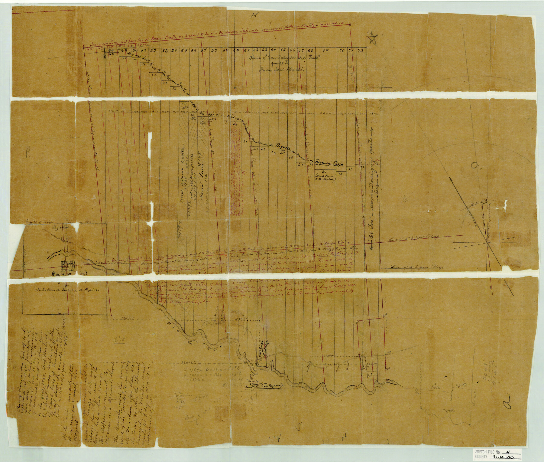
Hidalgo County Sketch File 4
Sk. Of surs. Along the Rio Grande on both sides of Edinburg
-
Map/Doc
11760
-
Collection
General Map Collection
-
People and Organizations
Andres Salinas (Surveyor/Engineer)
-
Counties
Hidalgo
-
Subjects
Surveying Sketch File
-
Height x Width
21.4 x 25.2 inches
54.4 x 64.0 cm
-
Medium
paper, manuscript
-
Features
San Salvador del Tule
Brownsville Road
Reynosa
Edinburgh
Hidalgo
Rio Grande
San Antonio de Reynosa
Cantu
Cazario
Jackom
Feltons
Sarron
Part of: General Map Collection
Bandera County Boundary File 7

Print $14.00
- Digital $50.00
Bandera County Boundary File 7
Size 12.7 x 8.1 inches
Map/Doc 50306

El Paso County Boundary File 24

Print $32.00
- Digital $50.00
El Paso County Boundary File 24
Size 14.8 x 9.6 inches
Map/Doc 53221
Colton's "New Medium" Map of the State of Texas, the Indian Territory, etc. from the latest & most authentic sources

Print $20.00
- Digital $50.00
Colton's "New Medium" Map of the State of Texas, the Indian Territory, etc. from the latest & most authentic sources
1884
Size 25.4 x 29.5 inches
Map/Doc 96524
Menard County Sketch File 29

Print $20.00
- Digital $50.00
Menard County Sketch File 29
1962
Size 21.0 x 41.1 inches
Map/Doc 10543
Harris County NRC Article 33.136 Sketch 6

Print $21.00
- Digital $50.00
Harris County NRC Article 33.136 Sketch 6
2003
Size 23.1 x 34.8 inches
Map/Doc 78664
El Paso County Rolled Sketch 31

Print $20.00
- Digital $50.00
El Paso County Rolled Sketch 31
1908
Size 39.9 x 32.0 inches
Map/Doc 8858
Concho County Rolled Sketch 2

Print $20.00
- Digital $50.00
Concho County Rolled Sketch 2
1887
Size 39.2 x 38.6 inches
Map/Doc 8647
Cooke County Sketch File 41

Print $36.00
- Digital $50.00
Cooke County Sketch File 41
1928
Size 11.3 x 8.9 inches
Map/Doc 19308
[Sketch for Mineral Application 16700 - Pecos River Bed]
![2808, [Sketch for Mineral Application 16700 - Pecos River Bed], General Map Collection](https://historictexasmaps.com/wmedia_w700/maps/2808.tif.jpg)
Print $20.00
- Digital $50.00
[Sketch for Mineral Application 16700 - Pecos River Bed]
1927
Size 19.9 x 30.9 inches
Map/Doc 2808
Wilbarger County Sketch File 28

Print $20.00
- Digital $50.00
Wilbarger County Sketch File 28
2016
Size 23.9 x 36.2 inches
Map/Doc 95324
Flight Mission No. DQN-3K, Frame 66, Calhoun County

Print $20.00
- Digital $50.00
Flight Mission No. DQN-3K, Frame 66, Calhoun County
1953
Size 18.7 x 22.5 inches
Map/Doc 84357
You may also like
Knox County Sketch File 22

Print $6.00
- Digital $50.00
Knox County Sketch File 22
1931
Size 11.2 x 8.8 inches
Map/Doc 29251
[Sketch showing A. B. & M. Block 2 in Potter and Randall Counties]
![91822, [Sketch showing A. B. & M. Block 2 in Potter and Randall Counties], Twichell Survey Records](https://historictexasmaps.com/wmedia_w700/maps/91822-1.tif.jpg)
Print $20.00
- Digital $50.00
[Sketch showing A. B. & M. Block 2 in Potter and Randall Counties]
1916
Size 27.2 x 33.4 inches
Map/Doc 91822
Trinity River, Bazzette Sheet

Print $4.00
- Digital $50.00
Trinity River, Bazzette Sheet
1925
Size 28.2 x 24.9 inches
Map/Doc 65218
[Connection to Block M-13]
![93040, [Connection to Block M-13], Twichell Survey Records](https://historictexasmaps.com/wmedia_w700/maps/93040-1.tif.jpg)
Print $40.00
- Digital $50.00
[Connection to Block M-13]
Size 27.1 x 60.0 inches
Map/Doc 93040
General Highway Map. Detail of Cities and Towns in Lubbock County, Texas [Lubbock and vicinity]
![79579, General Highway Map. Detail of Cities and Towns in Lubbock County, Texas [Lubbock and vicinity], Texas State Library and Archives](https://historictexasmaps.com/wmedia_w700/maps/79579.tif.jpg)
Print $20.00
General Highway Map. Detail of Cities and Towns in Lubbock County, Texas [Lubbock and vicinity]
1961
Size 18.2 x 24.7 inches
Map/Doc 79579
Austin Map and Street Guide [Recto]
![94162, Austin Map and Street Guide [Recto], General Map Collection](https://historictexasmaps.com/wmedia_w700/maps/94162.tif.jpg)
Austin Map and Street Guide [Recto]
1976
Size 35.4 x 22.7 inches
Map/Doc 94162
Dimmit County Sketch File 25

Print $4.00
- Digital $50.00
Dimmit County Sketch File 25
1885
Size 12.9 x 8.6 inches
Map/Doc 21142
Navarro County Sketch File 4

Print $6.00
- Digital $50.00
Navarro County Sketch File 4
1852
Size 7.5 x 7.2 inches
Map/Doc 32304
Dawson County Sketch File 27

Print $8.00
- Digital $50.00
Dawson County Sketch File 27
Size 12.6 x 8.5 inches
Map/Doc 20588
United States - Gulf Coast - Galveston to Rio Grande

Print $20.00
- Digital $50.00
United States - Gulf Coast - Galveston to Rio Grande
1940
Size 27.1 x 18.2 inches
Map/Doc 72758
Tahoka Heights Addition to Tahoka Located on the SE Quarter of Section 568

Print $20.00
- Digital $50.00
Tahoka Heights Addition to Tahoka Located on the SE Quarter of Section 568
Size 18.1 x 18.5 inches
Map/Doc 92939
Reagan County

Print $40.00
- Digital $50.00
Reagan County
1915
Size 48.8 x 36.0 inches
Map/Doc 78429