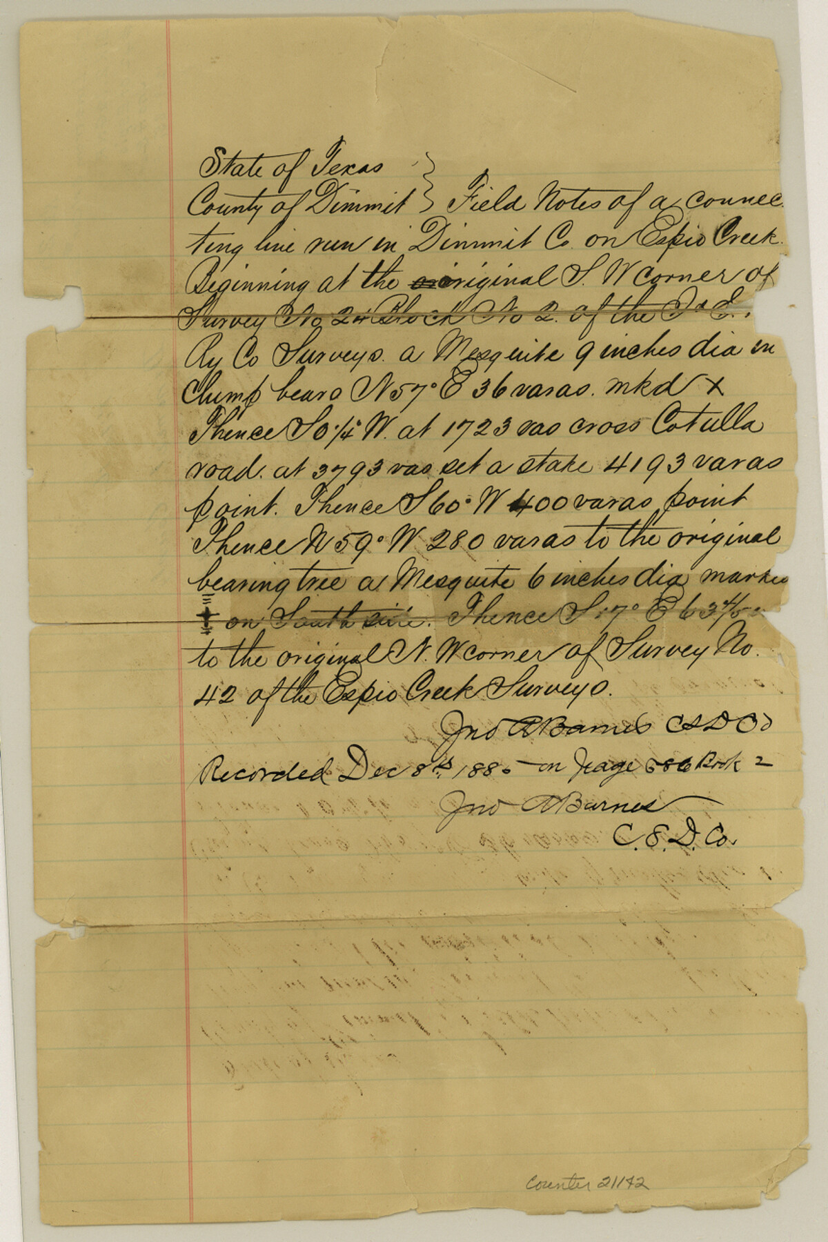
Dimmit County Sketch File 25
[Connecting line from southwest corner of number 24, Block 2, I. & G. N. RR. Co. to northwest corner of number 42, Espio Creek surveys]
-
Map/Doc
21142
-
Collection
General Map Collection
-
Object Dates
1885/12/8 (Creation Date)
1885/12/14 (File Date)
-
People and Organizations
Jno. A. Barnes (Surveyor/Engineer)
-
Counties
Dimmit
-
Subjects
Surveying Sketch File
-
Height x Width
12.9 x 8.6 inches
32.8 x 21.8 cm
-
Medium
paper, manuscript
-
Features
Espio Creek
Cotulla Road
Part of: General Map Collection
Map of San Augustine County

Print $20.00
- Digital $50.00
Map of San Augustine County
1839
Size 22.3 x 18.2 inches
Map/Doc 4011
Duval County Sketch File 9

Print $4.00
- Digital $50.00
Duval County Sketch File 9
1875
Size 10.9 x 8.7 inches
Map/Doc 21304
Terrell County Working Sketch 42

Print $20.00
- Digital $50.00
Terrell County Working Sketch 42
1957
Size 34.4 x 34.4 inches
Map/Doc 62135
Smith County Working Sketch 6

Print $20.00
- Digital $50.00
Smith County Working Sketch 6
1940
Size 15.7 x 25.7 inches
Map/Doc 63891
[Map of the City of South Padre Island]
![3212, [Map of the City of South Padre Island], General Map Collection](https://historictexasmaps.com/wmedia_w700/maps/3212-1.tif.jpg)
Print $20.00
- Digital $50.00
[Map of the City of South Padre Island]
1993
Size 12.5 x 36.5 inches
Map/Doc 3212


Blanco County Sketch File 46

Print $4.00
- Digital $50.00
Blanco County Sketch File 46
Size 12.5 x 8.4 inches
Map/Doc 14673
Dawson County Sketch File 27

Print $8.00
- Digital $50.00
Dawson County Sketch File 27
Size 12.6 x 8.5 inches
Map/Doc 20588
Val Verde County Rolled Sketch 59

Print $20.00
- Digital $50.00
Val Verde County Rolled Sketch 59
1947
Size 45.2 x 23.6 inches
Map/Doc 10078
Chambers County Sketch File 14

Print $8.00
- Digital $50.00
Chambers County Sketch File 14
1862
Size 4.3 x 5.1 inches
Map/Doc 17560
[Maps of surveys in Reeves & Culberson Cos]
![61146, [Maps of surveys in Reeves & Culberson Cos], General Map Collection](https://historictexasmaps.com/wmedia_w700/maps/61146.tif.jpg)
Print $20.00
- Digital $50.00
[Maps of surveys in Reeves & Culberson Cos]
1937
Size 30.8 x 24.9 inches
Map/Doc 61146
You may also like
Houston County Working Sketch 28

Print $20.00
- Digital $50.00
Houston County Working Sketch 28
1988
Size 30.2 x 37.8 inches
Map/Doc 66258
Trinity River, Bazzette Sheet

Print $4.00
- Digital $50.00
Trinity River, Bazzette Sheet
1925
Size 28.2 x 24.9 inches
Map/Doc 65218
Dimmit County Working Sketch 53

Print $20.00
- Digital $50.00
Dimmit County Working Sketch 53
1990
Size 25.5 x 26.0 inches
Map/Doc 68714
Webb County Rolled Sketch 48

Print $20.00
- Digital $50.00
Webb County Rolled Sketch 48
1943
Size 20.1 x 37.3 inches
Map/Doc 8204
Map of section no. 12 of a survey of Padre Island made for the Office of the Attorney General of the State of Texas

Print $40.00
- Digital $50.00
Map of section no. 12 of a survey of Padre Island made for the Office of the Attorney General of the State of Texas
1941
Size 75.9 x 41.0 inches
Map/Doc 2268
[Sections in the vicinity of John P. Rohus and Mary Fury surveys]
![92987, [Sections in the vicinity of John P. Rohus and Mary Fury surveys], Twichell Survey Records](https://historictexasmaps.com/wmedia_w700/maps/92987-1.tif.jpg)
Print $20.00
- Digital $50.00
[Sections in the vicinity of John P. Rohus and Mary Fury surveys]
Size 12.2 x 13.1 inches
Map/Doc 92987
Caldwell County Working Sketch 7

Print $20.00
- Digital $50.00
Caldwell County Working Sketch 7
1958
Size 29.7 x 37.2 inches
Map/Doc 67837
Nueces County Aerial Photograph Index Sheet 6

Print $20.00
- Digital $50.00
Nueces County Aerial Photograph Index Sheet 6
1956
Size 23.4 x 19.2 inches
Map/Doc 83739
Nueces County Rolled Sketch 103

Print $105.00
Nueces County Rolled Sketch 103
1985
Size 36.5 x 24.1 inches
Map/Doc 7078
[Surveys in the Bexar District along the San Antonio River showing the position of the missions]
![125, [Surveys in the Bexar District along the San Antonio River showing the position of the missions], General Map Collection](https://historictexasmaps.com/wmedia_w700/maps/125.tif.jpg)
Print $3.00
- Digital $50.00
[Surveys in the Bexar District along the San Antonio River showing the position of the missions]
1841
Size 11.2 x 16.0 inches
Map/Doc 125
Plat showing survey of tracts in the C. A. West survey A-337 and the Wm. Standiferd survey A-301 in Bastrop County as surveyed for the Veteran's Land Board

Print $20.00
- Digital $50.00
Plat showing survey of tracts in the C. A. West survey A-337 and the Wm. Standiferd survey A-301 in Bastrop County as surveyed for the Veteran's Land Board
1992
Size 34.9 x 46.8 inches
Map/Doc 61151
Pecos County Working Sketch 33

Print $20.00
- Digital $50.00
Pecos County Working Sketch 33
1937
Size 26.7 x 35.6 inches
Map/Doc 71505