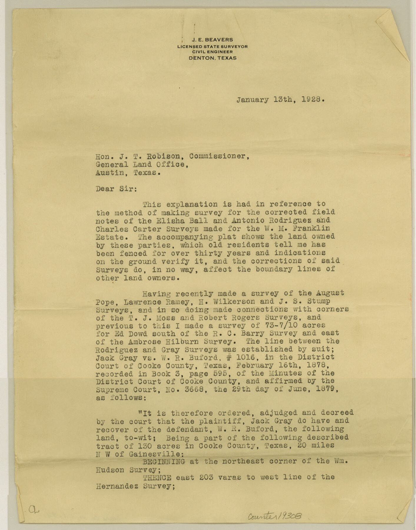
Cooke County Sketch File 41
Sketch & Connection of Ball, Carter & Rodriguez Surveys
-
Map/Doc
19308
-
Collection
General Map Collection
-
Object Dates
1928/1/13 (Creation Date)
1928/2/16 (File Date)
-
People and Organizations
J.E. Beavers (Surveyor/Engineer)
-
Counties
Cooke
-
Subjects
Surveying Sketch File
-
Height x Width
11.3 x 8.9 inches
28.7 x 22.6 cm
-
Medium
multi-page, multi-format
-
Features
Red River
Mountain Creek
Cedar Creek
Part of: General Map Collection
Hale County Sketch File 13

Print $20.00
- Digital $50.00
Hale County Sketch File 13
Size 36.5 x 23.0 inches
Map/Doc 10470
Uvalde County Rolled Sketch B

Print $20.00
- Digital $50.00
Uvalde County Rolled Sketch B
1847
Size 28.8 x 22.4 inches
Map/Doc 8105
Dallas County Boundary File 5a

Print $4.00
- Digital $50.00
Dallas County Boundary File 5a
Size 4.9 x 8.6 inches
Map/Doc 52182
Jackson County Sketch File 9

Print $24.00
- Digital $50.00
Jackson County Sketch File 9
1898
Size 11.3 x 8.8 inches
Map/Doc 27651
Flight Mission No. CLL-1N, Frame 30, Willacy County

Print $20.00
- Digital $50.00
Flight Mission No. CLL-1N, Frame 30, Willacy County
1954
Size 18.4 x 22.2 inches
Map/Doc 87011
Amistad International Reservoir on Rio Grande 86

Print $20.00
- Digital $50.00
Amistad International Reservoir on Rio Grande 86
1949
Size 28.3 x 40.1 inches
Map/Doc 75515
Presidio County Rolled Sketch 88

Print $20.00
- Digital $50.00
Presidio County Rolled Sketch 88
1946
Size 34.8 x 29.9 inches
Map/Doc 9780
Trinity River, Terrell Sheet/Kings Creek

Print $20.00
- Digital $50.00
Trinity River, Terrell Sheet/Kings Creek
1930
Size 42.3 x 19.7 inches
Map/Doc 65229
Wise County Sketch File 5

Print $6.00
- Digital $50.00
Wise County Sketch File 5
1856
Size 8.2 x 14.0 inches
Map/Doc 40531
Kerr County Working Sketch 15

Print $20.00
- Digital $50.00
Kerr County Working Sketch 15
1953
Size 36.2 x 38.6 inches
Map/Doc 70046
Castro County Working Sketch 4

Print $20.00
- Digital $50.00
Castro County Working Sketch 4
1920
Size 17.0 x 16.2 inches
Map/Doc 67899
[Capitol League Sketch in Bailey & Lamb Counties, Texas]
![1764, [Capitol League Sketch in Bailey & Lamb Counties, Texas], General Map Collection](https://historictexasmaps.com/wmedia_w700/maps/1764.tif.jpg)
Print $20.00
- Digital $50.00
[Capitol League Sketch in Bailey & Lamb Counties, Texas]
1910
Size 19.7 x 28.0 inches
Map/Doc 1764
You may also like
Tarrant County Working Sketch 19

Print $20.00
- Digital $50.00
Tarrant County Working Sketch 19
1999
Size 11.8 x 18.1 inches
Map/Doc 62436
[Map of Nueces Bay Showing Old Leases]
![2924, [Map of Nueces Bay Showing Old Leases], General Map Collection](https://historictexasmaps.com/wmedia_w700/maps/2924-1.tif.jpg)
Print $20.00
- Digital $50.00
[Map of Nueces Bay Showing Old Leases]
1936
Size 18.0 x 22.9 inches
Map/Doc 2924

Rio Grande, Run Sheet

Print $2.00
- Digital $50.00
Rio Grande, Run Sheet
1931
Size 17.0 x 14.3 inches
Map/Doc 65120
Kinney County Working Sketch 50

Print $20.00
- Digital $50.00
Kinney County Working Sketch 50
1980
Size 19.4 x 26.9 inches
Map/Doc 70232
Pecos County Rolled Sketch 50

Print $20.00
- Digital $50.00
Pecos County Rolled Sketch 50
1913
Size 23.5 x 13.0 inches
Map/Doc 7226
Right of Way and Track Map International & Gt Northern Ry. operated by the International & Gt. Northern Ry. Co., San Antonio Division

Print $40.00
- Digital $50.00
Right of Way and Track Map International & Gt Northern Ry. operated by the International & Gt. Northern Ry. Co., San Antonio Division
1917
Size 25.4 x 58.1 inches
Map/Doc 64787
Scurry County Rolled Sketch 14

Print $20.00
- Digital $50.00
Scurry County Rolled Sketch 14
2016
Size 23.4 x 41.4 inches
Map/Doc 95404
Nueces County Rolled Sketch 111

Print $20.00
- Digital $50.00
Nueces County Rolled Sketch 111
1991
Size 24.6 x 36.1 inches
Map/Doc 7119
Map of University Land in McLennan County

Print $20.00
- Digital $50.00
Map of University Land in McLennan County
1905
Size 35.1 x 32.9 inches
Map/Doc 2432
The Military History of Texas Map!

The Military History of Texas Map!
1996
Size 24.2 x 35.1 inches
Map/Doc 96827
Flight Mission No. DAG-18K, Frame 68, Matagorda County

Print $20.00
- Digital $50.00
Flight Mission No. DAG-18K, Frame 68, Matagorda County
1952
Size 16.4 x 16.3 inches
Map/Doc 86361