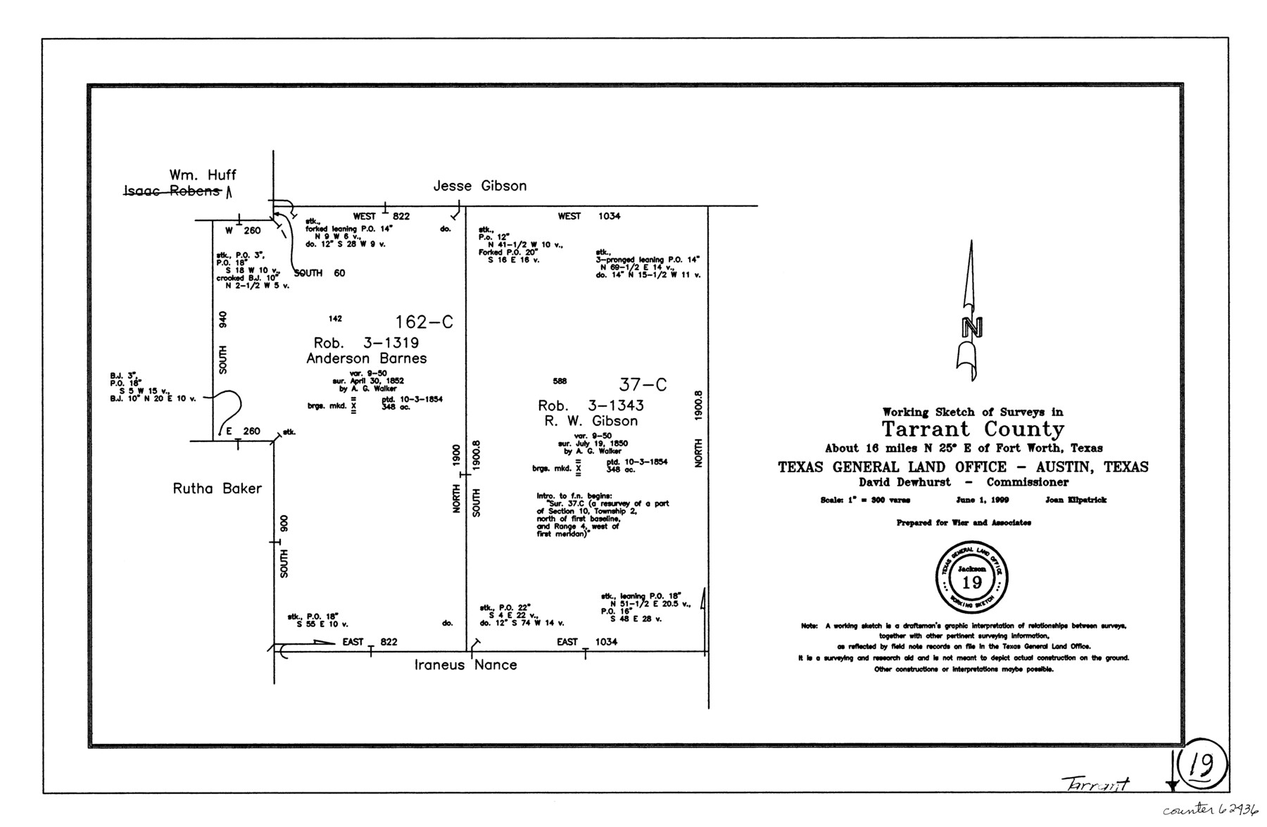
Tarrant County Working Sketch 19
-
Map/Doc
62436
-
Collection
General Map Collection
-
Object Dates
6/1/1999 (Creation Date)
-
People and Organizations
Joan Kilpatrick (Draftsman)
-
Counties
Tarrant
-
Subjects
Surveying Working Sketch
-
Height x Width
11.8 x 18.1 inches
30.0 x 46.0 cm
-
Scale
1" = 300 varas
Part of: General Map Collection
Lampasas County Working Sketch 12

Print $20.00
- Digital $50.00
Lampasas County Working Sketch 12
1969
Size 32.9 x 31.4 inches
Map/Doc 70289
Parker County Working Sketch 24

Print $20.00
- Digital $50.00
Parker County Working Sketch 24
2008
Map/Doc 88814
Kerr County Sketch File 6

Print $20.00
- Digital $50.00
Kerr County Sketch File 6
1879
Size 16.4 x 22.4 inches
Map/Doc 11917
Presidio County Working Sketch 9

Print $20.00
- Digital $50.00
Presidio County Working Sketch 9
1928
Size 40.7 x 18.5 inches
Map/Doc 71683
Tarrant County

Print $20.00
- Digital $50.00
Tarrant County
1857
Size 20.9 x 15.4 inches
Map/Doc 4628
Limestone County

Print $40.00
- Digital $50.00
Limestone County
1922
Size 50.6 x 36.2 inches
Map/Doc 73342
Flight Mission No. CGI-1N, Frame 222, Cameron County

Print $20.00
- Digital $50.00
Flight Mission No. CGI-1N, Frame 222, Cameron County
1955
Size 18.4 x 22.1 inches
Map/Doc 84532
Robertson County Working Sketch Graphic Index

Print $20.00
- Digital $50.00
Robertson County Working Sketch Graphic Index
1945
Size 46.8 x 37.9 inches
Map/Doc 76685
Wichita County Rolled Sketch 12

Print $20.00
- Digital $50.00
Wichita County Rolled Sketch 12
Size 20.2 x 22.3 inches
Map/Doc 8249
Right-of-Way & Track Map, Houston & Brazos Valley Ry. operated by Houston & Brazos Valley Ry.

Print $40.00
- Digital $50.00
Right-of-Way & Track Map, Houston & Brazos Valley Ry. operated by Houston & Brazos Valley Ry.
1918
Size 25.0 x 56.3 inches
Map/Doc 64603
The Military History of Texas Map!

The Military History of Texas Map!
1996
Size 24.2 x 35.0 inches
Map/Doc 96828
Flight Mission No. BRE-2P, Frame 73, Nueces County

Print $20.00
- Digital $50.00
Flight Mission No. BRE-2P, Frame 73, Nueces County
1956
Size 18.5 x 22.5 inches
Map/Doc 86768
You may also like
Live Oak County Working Sketch 27

Print $20.00
- Digital $50.00
Live Oak County Working Sketch 27
1982
Size 12.7 x 17.4 inches
Map/Doc 70612
Hood County Working Sketch 9

Print $20.00
- Digital $50.00
Hood County Working Sketch 9
1972
Size 28.0 x 31.7 inches
Map/Doc 66203
Bandera County Working Sketch 26

Print $20.00
- Digital $50.00
Bandera County Working Sketch 26
1951
Size 32.3 x 28.4 inches
Map/Doc 67622
Working Sketch in Archer County

Print $20.00
- Digital $50.00
Working Sketch in Archer County
1924
Size 30.3 x 42.2 inches
Map/Doc 90171
Angelina County Rolled Sketch 5

Print $40.00
- Digital $50.00
Angelina County Rolled Sketch 5
1993
Size 36.0 x 75.3 inches
Map/Doc 9328

Amistad International Reservoir on Rio Grande 105

Print $20.00
- Digital $50.00
Amistad International Reservoir on Rio Grande 105
1950
Size 28.5 x 40.8 inches
Map/Doc 75536
C.C. Slaughter's Running Water Ranch situated in Hale and Lamb Counties

Print $40.00
- Digital $50.00
C.C. Slaughter's Running Water Ranch situated in Hale and Lamb Counties
Size 38.1 x 55.5 inches
Map/Doc 89924
No. 1 - Survey for a road from the Brazo Santiago to the Rio Grande

Print $20.00
- Digital $50.00
No. 1 - Survey for a road from the Brazo Santiago to the Rio Grande
1847
Size 18.3 x 27.2 inches
Map/Doc 72874
Travis County Sketch File 62

Print $20.00
- Digital $50.00
Travis County Sketch File 62
1929
Size 20.6 x 18.2 inches
Map/Doc 12473
Packery Channel

Print $20.00
- Digital $50.00
Packery Channel
1975
Size 27.8 x 30.9 inches
Map/Doc 2994
Borden County Sketch File 12

Print $24.00
- Digital $50.00
Borden County Sketch File 12
Size 10.8 x 9.1 inches
Map/Doc 14732