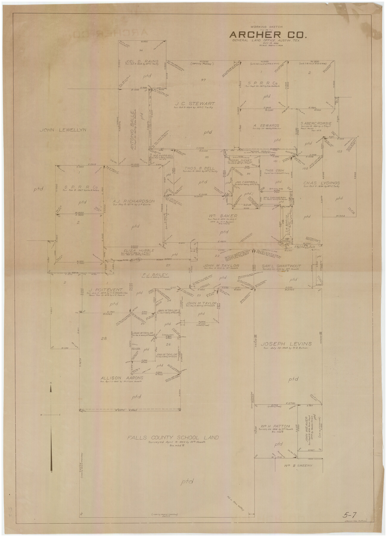
Working Sketch in Archer County
5-7
-
Map/Doc
90171
-
Collection
Twichell Survey Records
-
Object Dates
5/15/1924 (Creation Date)
-
People and Organizations
J. Bascom Giles (Draftsman)
-
Counties
Archer
-
Height x Width
30.3 x 42.2 inches
77.0 x 107.2 cm
Part of: Twichell Survey Records
General Highway Map, Crosby County, Texas

Print $20.00
- Digital $50.00
General Highway Map, Crosby County, Texas
1950
Size 25.5 x 18.8 inches
Map/Doc 92597
Map of Andrews

Print $20.00
- Digital $50.00
Map of Andrews
1928
Size 20.8 x 17.7 inches
Map/Doc 92452
University of Texas System University Lands

Print $20.00
- Digital $50.00
University of Texas System University Lands
1938
Size 17.9 x 23.5 inches
Map/Doc 93249
SW/4 of County, B.S.& F. Bk. M-10, J.W.Woodburn Bk.B-1 & G.C.&S.F. Bk.BIGN

Print $20.00
- Digital $50.00
SW/4 of County, B.S.& F. Bk. M-10, J.W.Woodburn Bk.B-1 & G.C.&S.F. Bk.BIGN
Size 34.6 x 27.0 inches
Map/Doc 90266
Plat of Fee Land Adjoining the Town of Lovington, New Mexico

Print $20.00
- Digital $50.00
Plat of Fee Land Adjoining the Town of Lovington, New Mexico
Size 24.2 x 18.4 inches
Map/Doc 92422
[Sketch showing T. &P. R. R. Co. Blks. 32, 33, 34 Township 4N, and J. Poitevent Block I]
![89629, [Sketch showing T. &P. R. R. Co. Blks. 32, 33, 34 Township 4N, and J. Poitevent Block I], Twichell Survey Records](https://historictexasmaps.com/wmedia_w700/maps/89629-1.tif.jpg)
Print $40.00
- Digital $50.00
[Sketch showing T. &P. R. R. Co. Blks. 32, 33, 34 Township 4N, and J. Poitevent Block I]
Size 19.2 x 49.8 inches
Map/Doc 89629
Official Map City of Lubbock Lubbock County, Texas

Print $20.00
- Digital $50.00
Official Map City of Lubbock Lubbock County, Texas
1927
Size 44.6 x 33.4 inches
Map/Doc 93220
[T. & P. Blocks 32-36, Townships 3N, 4N and 5N]
![90630, [T. & P. Blocks 32-36, Townships 3N, 4N and 5N], Twichell Survey Records](https://historictexasmaps.com/wmedia_w700/maps/90630.tif.jpg)
Print $20.00
- Digital $50.00
[T. & P. Blocks 32-36, Townships 3N, 4N and 5N]
Size 35.5 x 24.6 inches
Map/Doc 90630
Right-of-way & Track Map Dawson Railway Operated by the El Paso & Southwestern Company Station 1021+79.7 to Station 1233+41.7

Print $40.00
- Digital $50.00
Right-of-way & Track Map Dawson Railway Operated by the El Paso & Southwestern Company Station 1021+79.7 to Station 1233+41.7
1910
Size 57.0 x 25.1 inches
Map/Doc 89661
Grimes Estate Lands, Cochran County, Texas

Print $20.00
- Digital $50.00
Grimes Estate Lands, Cochran County, Texas
Size 25.6 x 21.6 inches
Map/Doc 92520
[PSL Blks A28 & A29]
![90165, [PSL Blks A28 & A29], Twichell Survey Records](https://historictexasmaps.com/wmedia_w700/maps/90165-1.tif.jpg)
Print $20.00
- Digital $50.00
[PSL Blks A28 & A29]
Size 18.2 x 22.8 inches
Map/Doc 90165
Block G, Section 160, Gaines County, Texas

Print $20.00
- Digital $50.00
Block G, Section 160, Gaines County, Texas
Size 19.7 x 24.0 inches
Map/Doc 92649
You may also like
Map of Atascosa Co.

Print $40.00
- Digital $50.00
Map of Atascosa Co.
1894
Size 48.3 x 46.6 inches
Map/Doc 4877
Bosque County Working Sketch 13

Print $20.00
- Digital $50.00
Bosque County Working Sketch 13
1957
Size 17.2 x 14.5 inches
Map/Doc 67446
Tracing from a map of Swisher Subdivision of part of the Isaac Decker league southside Colorado River an addition to the City of Austin

Print $20.00
- Digital $50.00
Tracing from a map of Swisher Subdivision of part of the Isaac Decker league southside Colorado River an addition to the City of Austin
1877
Size 24.0 x 14.6 inches
Map/Doc 455
[H. & G. N. Block 8 showing Llano and Espuella fence lines]
![90374, [H. & G. N. Block 8 showing Llano and Espuella fence lines], Twichell Survey Records](https://historictexasmaps.com/wmedia_w700/maps/90374-1.tif.jpg)
Print $2.00
- Digital $50.00
[H. & G. N. Block 8 showing Llano and Espuella fence lines]
Size 6.2 x 9.7 inches
Map/Doc 90374
Flight Mission No. DAG-21K, Frame 124, Matagorda County

Print $20.00
- Digital $50.00
Flight Mission No. DAG-21K, Frame 124, Matagorda County
1952
Size 18.5 x 22.4 inches
Map/Doc 86450
Capitol Grounds, Austin

Print $20.00
- Digital $50.00
Capitol Grounds, Austin
Size 35.4 x 40.5 inches
Map/Doc 16955
Blanco County Rolled Sketch 21

Print $20.00
- Digital $50.00
Blanco County Rolled Sketch 21
2007
Size 18.1 x 13.0 inches
Map/Doc 87925
Bennett and Norman, 30 Acres

Print $20.00
- Digital $50.00
Bennett and Norman, 30 Acres
Size 27.9 x 9.7 inches
Map/Doc 92721
Lamar County Working Sketch 1

Print $20.00
- Digital $50.00
Lamar County Working Sketch 1
Size 19.0 x 18.2 inches
Map/Doc 70262
University Lands Hudspeth County, Texas, Blocks A to N

Print $40.00
- Digital $50.00
University Lands Hudspeth County, Texas, Blocks A to N
Size 38.9 x 55.2 inches
Map/Doc 62952
Lubbock County

Print $20.00
- Digital $50.00
Lubbock County
1892
Size 25.0 x 20.6 inches
Map/Doc 66910
A Correct Map of the Seat of War in Mexico Being a Copy of Genl Arista's Map, taken at Resaca de la Palma, with additions and Corrections

Print $20.00
- Digital $50.00
A Correct Map of the Seat of War in Mexico Being a Copy of Genl Arista's Map, taken at Resaca de la Palma, with additions and Corrections
1847
Size 30.7 x 22.5 inches
Map/Doc 93962