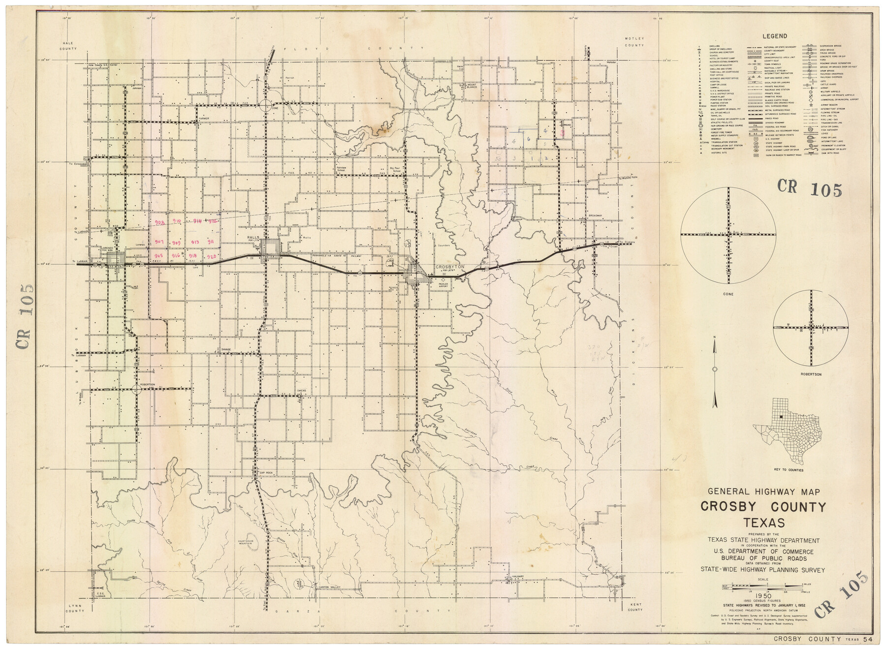
General Highway Map, Crosby County, Texas
CR105
-
Map/Doc
92597
-
Collection
Twichell Survey Records
-
Object Dates
1950 (Creation Date)
-
Counties
Crosby
-
Subjects
County
-
Height x Width
25.5 x 18.8 inches
64.8 x 47.8 cm
Part of: Twichell Survey Records
[Township 3 North, Block 31]
![91217, [Township 3 North, Block 31], Twichell Survey Records](https://historictexasmaps.com/wmedia_w700/maps/91217-1.tif.jpg)
Print $3.00
- Digital $50.00
[Township 3 North, Block 31]
Size 11.6 x 13.4 inches
Map/Doc 91217
[Blocks 3, 5 & Q]
![91275, [Blocks 3, 5 & Q], Twichell Survey Records](https://historictexasmaps.com/wmedia_w700/maps/91275-1.tif.jpg)
Print $20.00
- Digital $50.00
[Blocks 3, 5 & Q]
Size 19.4 x 9.2 inches
Map/Doc 91275
[Capitol Leagues, Blocks 49 H. & T. C. RR. Company, Block LC2]
![90769, [Capitol Leagues, Blocks 49 H. & T. C. RR. Company, Block LC2], Twichell Survey Records](https://historictexasmaps.com/wmedia_w700/maps/90769-1.tif.jpg)
Print $20.00
- Digital $50.00
[Capitol Leagues, Blocks 49 H. & T. C. RR. Company, Block LC2]
1883
Size 39.2 x 24.8 inches
Map/Doc 90769
[Subdivision Plat of 80 acres]
![93075, [Subdivision Plat of 80 acres], Twichell Survey Records](https://historictexasmaps.com/wmedia_w700/maps/93075-1.tif.jpg)
Print $2.00
- Digital $50.00
[Subdivision Plat of 80 acres]
Size 11.7 x 6.2 inches
Map/Doc 93075
East Line of Lipscomb County

Print $20.00
- Digital $50.00
East Line of Lipscomb County
Size 8.9 x 21.8 inches
Map/Doc 91318
[Strickland Survey Sketch Showing Abercrombie Corner, Exhibit C]
![91370, [Strickland Survey Sketch Showing Abercrombie Corner, Exhibit C], Twichell Survey Records](https://historictexasmaps.com/wmedia_w700/maps/91370-1.tif.jpg)
Print $20.00
- Digital $50.00
[Strickland Survey Sketch Showing Abercrombie Corner, Exhibit C]
Size 25.3 x 19.1 inches
Map/Doc 91370
Borden County Working Sketch of Geo. Spiller's Resurvey of Block 97 made in 1887

Print $3.00
- Digital $50.00
Borden County Working Sketch of Geo. Spiller's Resurvey of Block 97 made in 1887
1903
Size 10.1 x 16.6 inches
Map/Doc 90211
General Highway Map, Yoakum County Texas

Print $20.00
- Digital $50.00
General Highway Map, Yoakum County Texas
1952
Size 26.3 x 19.1 inches
Map/Doc 92815
[H. & G. N. Block 1]
![90939, [H. & G. N. Block 1], Twichell Survey Records](https://historictexasmaps.com/wmedia_w700/maps/90939-1.tif.jpg)
Print $20.00
- Digital $50.00
[H. & G. N. Block 1]
1902
Size 13.5 x 16.4 inches
Map/Doc 90939
Original Town of Nadine, Lea County, New Mexico

Print $20.00
- Digital $50.00
Original Town of Nadine, Lea County, New Mexico
Size 27.1 x 33.5 inches
Map/Doc 92420
[Lynn and Adjacent Counties]
![92961, [Lynn and Adjacent Counties], Twichell Survey Records](https://historictexasmaps.com/wmedia_w700/maps/92961-1.tif.jpg)
Print $20.00
- Digital $50.00
[Lynn and Adjacent Counties]
Size 24.6 x 18.8 inches
Map/Doc 92961
[Sketch showing G. & M. Block 5]
![91704, [Sketch showing G. & M. Block 5], Twichell Survey Records](https://historictexasmaps.com/wmedia_w700/maps/91704-1.tif.jpg)
Print $2.00
- Digital $50.00
[Sketch showing G. & M. Block 5]
Size 7.5 x 5.8 inches
Map/Doc 91704
You may also like
[Rand McNally's Indexed Map of Texas and Indian Territory]
![93992, [Rand McNally's Indexed Map of Texas and Indian Territory], Rees-Jones Digital Map Collection](https://historictexasmaps.com/wmedia_w700/maps/93992.tif.jpg)
Print $20.00
- Digital $50.00
[Rand McNally's Indexed Map of Texas and Indian Territory]
Size 26.0 x 20.6 inches
Map/Doc 93992
Goliad County Sketch File 23

Print $4.00
- Digital $50.00
Goliad County Sketch File 23
1877
Size 8.1 x 12.8 inches
Map/Doc 24295
Polk County Working Sketch 23b

Print $40.00
- Digital $50.00
Polk County Working Sketch 23b
1957
Size 28.8 x 54.6 inches
Map/Doc 71639
Hunt County Sketch File 26

Print $4.00
- Digital $50.00
Hunt County Sketch File 26
1851
Size 8.4 x 12.9 inches
Map/Doc 27124
Current Miscellaneous File 15

Print $16.00
- Digital $50.00
Current Miscellaneous File 15
1951
Size 10.7 x 8.2 inches
Map/Doc 73822
Flight Mission No. DQN-2K, Frame 118, Calhoun County

Print $20.00
- Digital $50.00
Flight Mission No. DQN-2K, Frame 118, Calhoun County
1953
Size 18.5 x 22.2 inches
Map/Doc 84294
Brooks County Rolled Sketch 11A

Print $20.00
- Digital $50.00
Brooks County Rolled Sketch 11A
1906
Size 18.1 x 24.6 inches
Map/Doc 76060
University Land Field Note Volume Index

University Land Field Note Volume Index
2023
Size 8.5 x 11.0 inches
Map/Doc 97177


Val Verde County Rolled Sketch 51

Print $40.00
- Digital $50.00
Val Verde County Rolled Sketch 51
1937
Size 29.4 x 48.4 inches
Map/Doc 10075
Kent County Boundary File 4a

Print $18.00
- Digital $50.00
Kent County Boundary File 4a
Size 14.2 x 8.5 inches
Map/Doc 55838