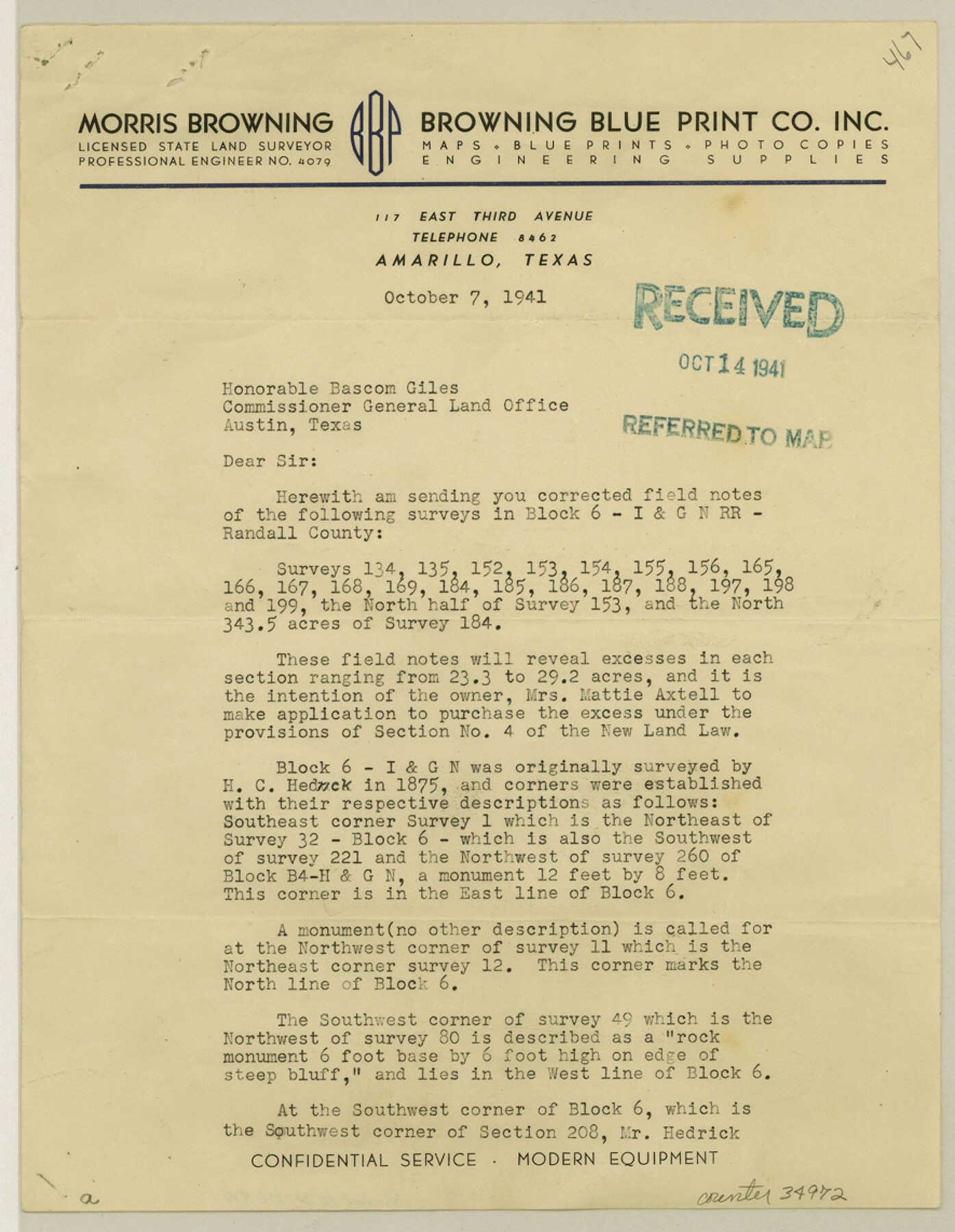
Randall County Sketch File 10
[Surveyor's statement regarding Block 6, I. & G. N. R.R. Co.]
-
Map/Doc
34972
-
Collection
General Map Collection
-
Object Dates
10/7/1941 (Creation Date)
10/14/1941 (File Date)
-
People and Organizations
Morris Browning (Surveyor/Engineer)
-
Counties
Randall
-
Subjects
Surveying Sketch File
-
Height x Width
11.4 x 8.8 inches
29.0 x 22.4 cm
-
Medium
paper, print
Part of: General Map Collection
Map of Jones County West of the Clearfork of the Brazos River Young - East of it Milam - Land District

Print $20.00
- Digital $50.00
Map of Jones County West of the Clearfork of the Brazos River Young - East of it Milam - Land District
1859
Size 22.0 x 26.5 inches
Map/Doc 3741
Flight Mission No. DQN-1K, Frame 70, Calhoun County

Print $20.00
- Digital $50.00
Flight Mission No. DQN-1K, Frame 70, Calhoun County
1953
Size 18.6 x 22.3 inches
Map/Doc 84157
Wood County Boundary File 6

Print $32.00
- Digital $50.00
Wood County Boundary File 6
Size 14.3 x 8.6 inches
Map/Doc 60180
[Surveys near Lake Soda made under G.W. Smyth, Commissioner]
![73, [Surveys near Lake Soda made under G.W. Smyth, Commissioner], General Map Collection](https://historictexasmaps.com/wmedia_w700/maps/73.tif.jpg)
Print $20.00
- Digital $50.00
[Surveys near Lake Soda made under G.W. Smyth, Commissioner]
1835
Size 16.0 x 19.3 inches
Map/Doc 73
Sutton County Sketch File E2

Print $20.00
- Digital $50.00
Sutton County Sketch File E2
Size 16.8 x 19.0 inches
Map/Doc 12397
Fort Bend County Boundary File 1

Print $80.00
- Digital $50.00
Fort Bend County Boundary File 1
Size 25.0 x 69.7 inches
Map/Doc 53553
Crockett County Working Sketch 47

Print $20.00
- Digital $50.00
Crockett County Working Sketch 47
1935
Size 37.5 x 36.9 inches
Map/Doc 68380
Hudspeth County Rolled Sketch 38

Print $20.00
- Digital $50.00
Hudspeth County Rolled Sketch 38
1939
Size 18.0 x 37.5 inches
Map/Doc 6251
Dickens County Sketch File K

Print $6.00
- Digital $50.00
Dickens County Sketch File K
1907
Size 14.5 x 9.1 inches
Map/Doc 20889
Travis County Rolled Sketch 27

Print $20.00
- Digital $50.00
Travis County Rolled Sketch 27
1945
Size 23.5 x 17.8 inches
Map/Doc 8029
La Salle County Sketch File 48

Print $6.00
- Digital $50.00
La Salle County Sketch File 48
1942
Size 11.2 x 8.8 inches
Map/Doc 29617
Tom Green County Boundary File 87b

Print $4.00
- Digital $50.00
Tom Green County Boundary File 87b
Size 13.0 x 8.6 inches
Map/Doc 59401
You may also like
Bosque County, Texas School Map

Print $20.00
- Digital $50.00
Bosque County, Texas School Map
1932
Size 40.9 x 36.6 inches
Map/Doc 81918
Tom Green County Sketch File 86

Print $8.00
- Digital $50.00
Tom Green County Sketch File 86
1986
Size 14.2 x 8.9 inches
Map/Doc 38260
Comanche County Sketch File 6

Print $4.00
- Digital $50.00
Comanche County Sketch File 6
1854
Size 12.7 x 8.4 inches
Map/Doc 19061
Collin County Boundary File 18d

Print $20.00
- Digital $50.00
Collin County Boundary File 18d
Size 12.8 x 8.2 inches
Map/Doc 51739
Lavaca County Working Sketch 2

Print $20.00
- Digital $50.00
Lavaca County Working Sketch 2
1904
Size 19.2 x 31.2 inches
Map/Doc 70355
Kleberg County Rolled Sketch 8

Print $20.00
- Digital $50.00
Kleberg County Rolled Sketch 8
1947
Size 33.0 x 42.0 inches
Map/Doc 9360
Hardeman County Sketch File 8a

Print $20.00
- Digital $50.00
Hardeman County Sketch File 8a
Size 16.0 x 32.0 inches
Map/Doc 11623
Acts of the Visit of the Royal Commissioners (sometimes referred to as the “Visita General”) - Camargo

Acts of the Visit of the Royal Commissioners (sometimes referred to as the “Visita General”) - Camargo
1767
Size 14.3 x 9.5 inches
Map/Doc 94254
Coryell County Sketch File 17 1/4

Print $4.00
- Digital $50.00
Coryell County Sketch File 17 1/4
Size 8.7 x 14.9 inches
Map/Doc 19377
Brewster County Rolled Sketch 62

Print $40.00
- Digital $50.00
Brewster County Rolled Sketch 62
1939
Size 89.5 x 44.0 inches
Map/Doc 8487
Houston County Sketch File 7

Print $6.00
- Digital $50.00
Houston County Sketch File 7
1861
Size 12.0 x 11.1 inches
Map/Doc 26764
Victoria County Rolled Sketch 4A

Print $40.00
- Digital $50.00
Victoria County Rolled Sketch 4A
Size 66.4 x 43.9 inches
Map/Doc 10095