Brewster County Rolled Sketch 62
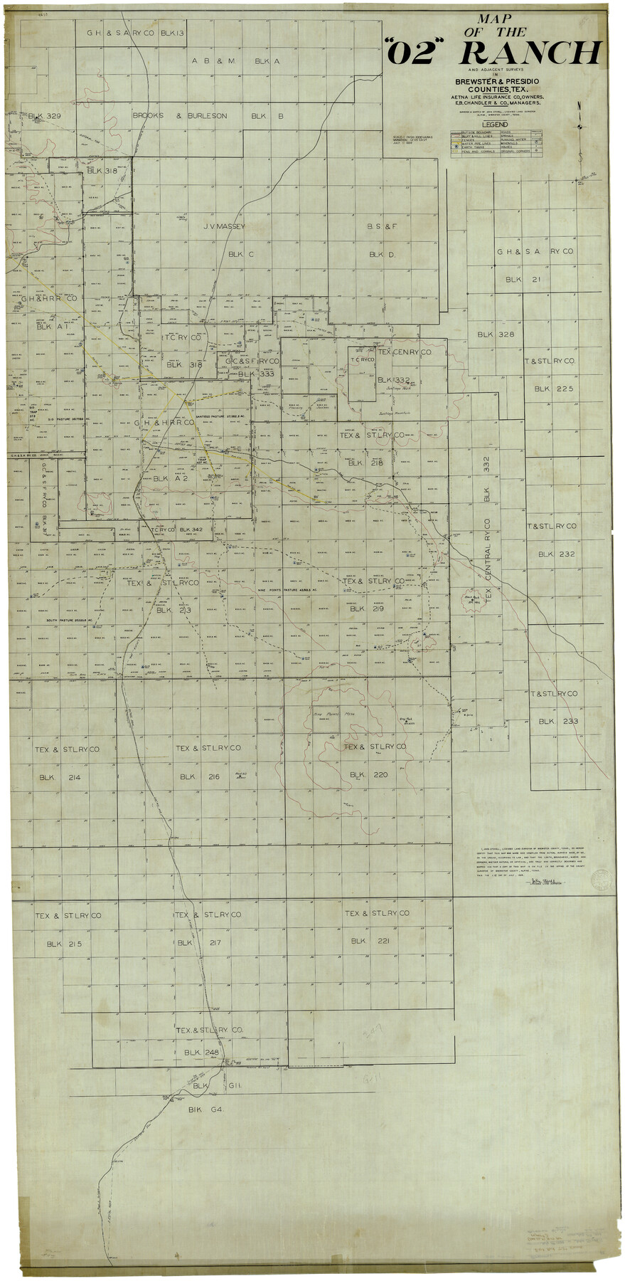
[East Part] Map of the "O2" Ranch and adjacent surveys in Brewster & Presidio Counties, Tex. Aetna Life Insurance Co., Owners. E.B. Chandler & Co., Managers.
-
Map/Doc
8487
-
Collection
General Map Collection
-
Object Dates
7/1/1939 (Creation Date)
7/11/1939 (File Date)
-
People and Organizations
John Stovell (Surveyor/Engineer)
-
Counties
Brewster Presidio
-
Subjects
Surveying Rolled Sketch
-
Height x Width
89.5 x 44.0 inches
227.3 x 111.8 cm
-
Medium
linen, manuscript
-
Scale
1" = 1000 varas
-
Comments
See Brewster County Rolled Sketch 63 (8488) for west part of sketch and Brewster County Sketch File N-17 (15651) for report.
Related maps
Brewster County Sketch File N-17

Print $80.00
- Digital $50.00
Brewster County Sketch File N-17
1939
Size 8.9 x 14.4 inches
Map/Doc 15651
Brewster County Sketch File NS-5

Print $22.00
- Digital $50.00
Brewster County Sketch File NS-5
Size 11.2 x 8.8 inches
Map/Doc 15983
Brewster County Rolled Sketch 63

Print $40.00
- Digital $50.00
Brewster County Rolled Sketch 63
1939
Size 77.1 x 43.6 inches
Map/Doc 8488
Part of: General Map Collection
Flight Mission No. CLL-4N, Frame 33, Willacy County

Print $20.00
- Digital $50.00
Flight Mission No. CLL-4N, Frame 33, Willacy County
1954
Size 18.3 x 22.0 inches
Map/Doc 87106
Brown County Sketch File 3

Print $2.00
- Digital $50.00
Brown County Sketch File 3
Size 8.3 x 5.9 inches
Map/Doc 16584
Webb County Rolled Sketch 65

Print $20.00
- Digital $50.00
Webb County Rolled Sketch 65
1949
Size 37.1 x 24.3 inches
Map/Doc 8214
Austin Street Map & Guide

Digital $50.00
Austin Street Map & Guide
Size 35.3 x 23.2 inches
Map/Doc 94434
[Red River & Southwestern Ry. Co. from Henrietta to Archer City]
![64147, [Red River & Southwestern Ry. Co. from Henrietta to Archer City], General Map Collection](https://historictexasmaps.com/wmedia_w700/maps/64147.tif.jpg)
Print $20.00
- Digital $50.00
[Red River & Southwestern Ry. Co. from Henrietta to Archer City]
Size 14.3 x 21.1 inches
Map/Doc 64147
Val Verde County Sketch File C

Print $62.00
- Digital $50.00
Val Verde County Sketch File C
1898
Size 15.5 x 19.8 inches
Map/Doc 12545
Franklin County Sketch File 9

Print $20.00
- Digital $50.00
Franklin County Sketch File 9
Size 13.6 x 23.1 inches
Map/Doc 11515
Red River County

Print $20.00
- Digital $50.00
Red River County
1934
Size 45.0 x 38.6 inches
Map/Doc 77405
Leon County Working Sketch 55

Print $20.00
- Digital $50.00
Leon County Working Sketch 55
1989
Size 18.7 x 18.3 inches
Map/Doc 70455
Hemphill County Sketch File 6a

Print $10.00
- Digital $50.00
Hemphill County Sketch File 6a
1903
Size 9.2 x 6.1 inches
Map/Doc 26303
Starr County Rolled Sketch 20

Print $20.00
- Digital $50.00
Starr County Rolled Sketch 20
1921
Size 23.6 x 15.4 inches
Map/Doc 7804
[Sketch for Mineral Application 13439 - Old River, Walle Merritt]
![65689, [Sketch for Mineral Application 13439 - Old River, Walle Merritt], General Map Collection](https://historictexasmaps.com/wmedia_w700/maps/65689-1.tif.jpg)
Print $20.00
- Digital $50.00
[Sketch for Mineral Application 13439 - Old River, Walle Merritt]
1925
Size 41.0 x 19.0 inches
Map/Doc 65689
You may also like
Flight Mission No. BQR-13K, Frame 26, Brazoria County

Print $20.00
- Digital $50.00
Flight Mission No. BQR-13K, Frame 26, Brazoria County
1952
Size 18.7 x 22.4 inches
Map/Doc 84074
Cherokee County Working Sketch 28

Print $20.00
- Digital $50.00
Cherokee County Working Sketch 28
1991
Size 13.7 x 16.8 inches
Map/Doc 67983
Pecos County Working Sketch 128

Print $20.00
- Digital $50.00
Pecos County Working Sketch 128
1975
Size 20.4 x 21.5 inches
Map/Doc 71602
Matagorda County NRC Article 33.136 Sketch 18

Print $24.00
Matagorda County NRC Article 33.136 Sketch 18
2023
Map/Doc 97283
Smith Co. showing location of Texas and Pacific Railway

Print $20.00
- Digital $50.00
Smith Co. showing location of Texas and Pacific Railway
1872
Size 19.5 x 21.6 inches
Map/Doc 64139
Bee County Sketch File 4

Print $6.00
- Digital $50.00
Bee County Sketch File 4
1858
Size 16.7 x 10.0 inches
Map/Doc 14268
Kerr County Working Sketch 20

Print $20.00
- Digital $50.00
Kerr County Working Sketch 20
1960
Size 37.1 x 41.5 inches
Map/Doc 70051
Jim Wells County Working Sketch 6

Print $20.00
- Digital $50.00
Jim Wells County Working Sketch 6
1943
Size 33.3 x 21.2 inches
Map/Doc 66604
The Republic County of Liberty. January 20, 1841

Print $20.00
The Republic County of Liberty. January 20, 1841
2020
Size 19.9 x 21.7 inches
Map/Doc 96209
Map of Uvalde Co.

Print $20.00
- Digital $50.00
Map of Uvalde Co.
Size 41.0 x 43.9 inches
Map/Doc 63090
[Sketch of PSL Blocks A20, A35, A44, A45]
![89739, [Sketch of PSL Blocks A20, A35, A44, A45], Twichell Survey Records](https://historictexasmaps.com/wmedia_w700/maps/89739-1.tif.jpg)
Print $40.00
- Digital $50.00
[Sketch of PSL Blocks A20, A35, A44, A45]
Size 22.7 x 66.9 inches
Map/Doc 89739
Hidalgo County Rolled Sketch 15

Print $40.00
- Digital $50.00
Hidalgo County Rolled Sketch 15
1963
Size 68.9 x 41.9 inches
Map/Doc 9170