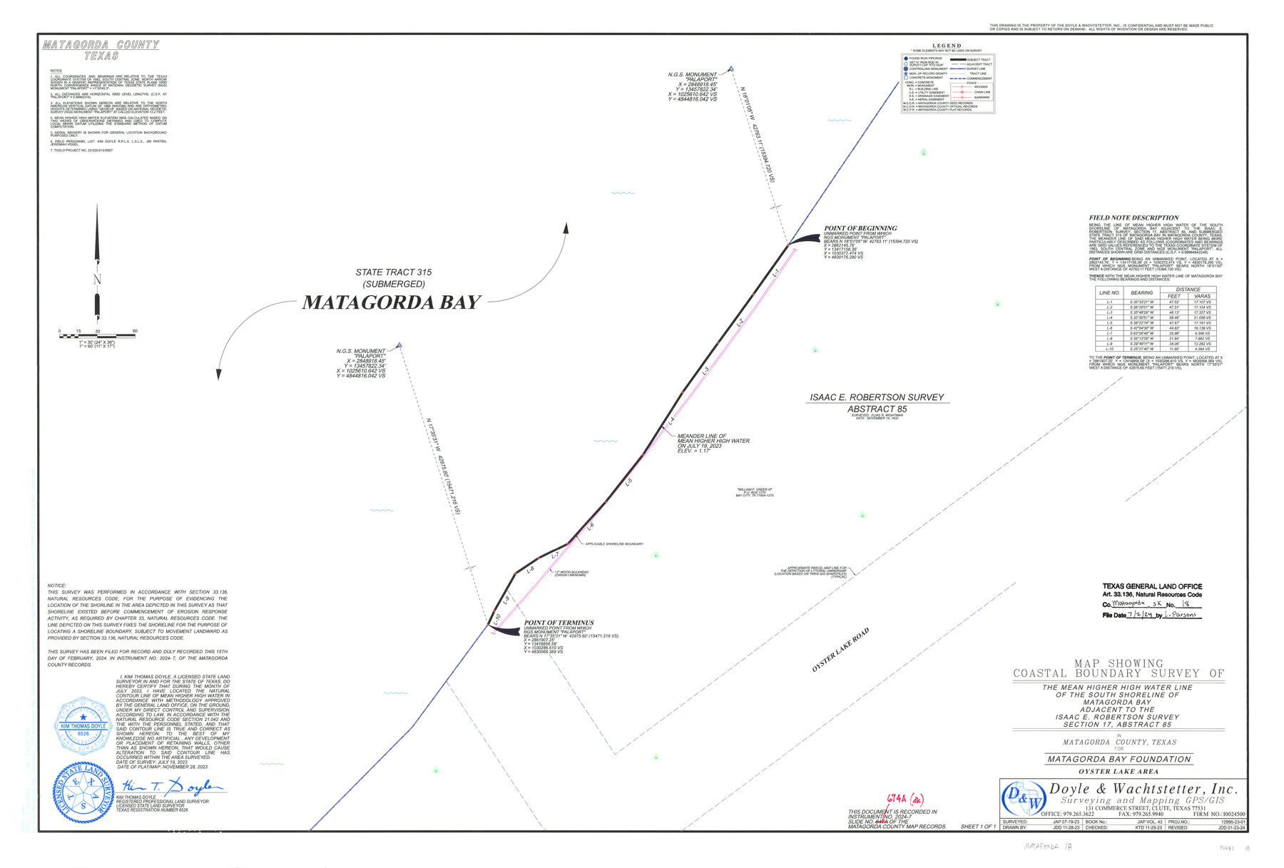
Matagorda County NRC Article 33.136 Sketch 18
Coastal Boundary Survey of the mean higher high water line of the south shoreline of Matagorda Bay adjacent to the Isaac E. Robertson Survey Section 17, Abstract 85
-
Map/Doc
97283
-
Collection
General Map Collection
-
Object Dates
11/28/2023 (Creation Date)
7/2/2024 (File Date)
7/19/2023 (Survey Date)
1/23/2024 (Revision Date)
-
People and Organizations
Kim Thomas Doyle (Surveyor/Engineer)
-
Counties
Matagorda
-
Subjects
Surveying CBS
-
Comments
Project: Matagorda Bay Foundation - Oyster Lake Area, Matagorda County
Project No.: TGLO CMP No. 23-020-013-D607
Part of: General Map Collection

Comal County Working Sketch 19

Print $20.00
- Digital $50.00
Comal County Working Sketch 19
2006
Size 18.8 x 29.0 inches
Map/Doc 83094
Roberts County Working Sketch 34

Print $20.00
- Digital $50.00
Roberts County Working Sketch 34
1978
Size 26.6 x 22.5 inches
Map/Doc 63560
Coleman County Working Sketch 5

Print $20.00
- Digital $50.00
Coleman County Working Sketch 5
1928
Size 27.0 x 25.6 inches
Map/Doc 68071
Nacogdoches County Boundary File 1b

Print $20.00
- Digital $50.00
Nacogdoches County Boundary File 1b
Size 21.2 x 4.9 inches
Map/Doc 57580
Comanche County Sketch File 29

Print $23.00
- Digital $50.00
Comanche County Sketch File 29
1954
Size 13.4 x 10.2 inches
Map/Doc 19120
Bee County Working Sketch 28

Print $20.00
- Digital $50.00
Bee County Working Sketch 28
1988
Size 48.2 x 34.6 inches
Map/Doc 67278
Flight Mission No. DAG-17K, Frame 78, Matagorda County

Print $20.00
- Digital $50.00
Flight Mission No. DAG-17K, Frame 78, Matagorda County
1952
Size 18.7 x 22.4 inches
Map/Doc 86337
Shackelford County Sketch File 3

Print $8.00
- Digital $50.00
Shackelford County Sketch File 3
1852
Size 8.2 x 7.3 inches
Map/Doc 36574
Gregg County Rolled Sketch FB

Print $84.00
- Digital $50.00
Gregg County Rolled Sketch FB
1932
Size 25.2 x 56.7 inches
Map/Doc 9326
Ride the Texas Independence Trail [Recto]
![94166, Ride the Texas Independence Trail [Recto], General Map Collection](https://historictexasmaps.com/wmedia_w700/maps/94166.tif.jpg)
Ride the Texas Independence Trail [Recto]
1968
Size 18.4 x 24.5 inches
Map/Doc 94166
Coke County Sketch File 29

Print $20.00
- Digital $50.00
Coke County Sketch File 29
Size 10.9 x 21.8 inches
Map/Doc 11114
You may also like
Taylor County Rolled Sketch 30A

Print $20.00
- Digital $50.00
Taylor County Rolled Sketch 30A
Size 17.5 x 11.3 inches
Map/Doc 76410
[Joaquin Galan Grant, Webb County]
![583, [Joaquin Galan Grant, Webb County], Maddox Collection](https://historictexasmaps.com/wmedia_w700/maps/583-1.tif.jpg)
Print $20.00
- Digital $50.00
[Joaquin Galan Grant, Webb County]
1882
Size 12.4 x 11.7 inches
Map/Doc 583
Reclamation & Navigation Map of Trinity River Flood Plain

Print $40.00
- Digital $50.00
Reclamation & Navigation Map of Trinity River Flood Plain
1930
Size 24.3 x 75.8 inches
Map/Doc 65178
General Highway Map, Martin County, Texas

Print $20.00
General Highway Map, Martin County, Texas
1961
Size 18.1 x 24.6 inches
Map/Doc 79583
Harris County Working Sketch 78

Print $20.00
- Digital $50.00
Harris County Working Sketch 78
1968
Size 32.8 x 25.8 inches
Map/Doc 65970
Pecos County Working Sketch 126

Print $20.00
- Digital $50.00
Pecos County Working Sketch 126
1936
Size 15.3 x 27.4 inches
Map/Doc 71600
Map of DeWitt County

Print $20.00
- Digital $50.00
Map of DeWitt County
1881
Size 21.7 x 24.3 inches
Map/Doc 3478
Pecos County Rolled Sketch 144

Print $20.00
- Digital $50.00
Pecos County Rolled Sketch 144
1956
Size 28.5 x 29.8 inches
Map/Doc 7277
Chambers County Sketch File B

Print $2.00
- Digital $50.00
Chambers County Sketch File B
1907
Size 7.2 x 8.5 inches
Map/Doc 17515
Bell County Sketch File 19

Print $4.00
- Digital $50.00
Bell County Sketch File 19
Size 7.6 x 7.7 inches
Map/Doc 14402
Brewster County Sketch File 23

Print $12.00
- Digital $50.00
Brewster County Sketch File 23
1958
Size 11.3 x 8.7 inches
Map/Doc 15825
Parker County Working Sketch 18

Print $20.00
- Digital $50.00
Parker County Working Sketch 18
2000
Map/Doc 71468