Matagorda County Rolled Sketch 37A

Print $40.00
- Digital $50.00
Matagorda County Rolled Sketch 37A
Size: 48.7 x 41.1 inches
10195
Matagorda County Rolled Sketch 37C

Print $20.00
- Digital $50.00
Matagorda County Rolled Sketch 37C
Size: 11.6 x 14.3 inches
10197
Jackson County Sketch File 8

Print $20.00
- Digital $50.00
Jackson County Sketch File 8
Size: 30.5 x 35.7 inches
10503
Matagorda County Sketch File 32

Print $20.00
- Digital $50.00
Matagorda County Sketch File 32
1918
Size: 36.5 x 30.4 inches
10531
Matagorda County Rolled Sketch 39

Print $40.00
- Digital $50.00
Matagorda County Rolled Sketch 39
1973
Size: 24.4 x 114.0 inches
10743
Calhoun County Sketch File 1

Print $7.00
- Digital $50.00
Calhoun County Sketch File 1
1855
Size: 17.1 x 11.0 inches
11031
Jackson County Sketch File 4

Print $20.00
- Digital $50.00
Jackson County Sketch File 4
Size: 18.2 x 22.7 inches
11834
Jackson County Sketch File 13

Print $40.00
- Digital $50.00
Jackson County Sketch File 13
Size: 29.0 x 18.6 inches
11839
Jackson County Sketch File 17

Print $20.00
- Digital $50.00
Jackson County Sketch File 17
1913
Size: 19.4 x 19.1 inches
11841
Jackson County Sketch File 25

Print $20.00
- Digital $50.00
Jackson County Sketch File 25
1942
Size: 15.4 x 37.4 inches
11845
Jackson County Sketch File 27

Print $20.00
- Digital $50.00
Jackson County Sketch File 27
1938
Size: 25.6 x 24.8 inches
11847
Matagorda County Sketch File 7

Print $20.00
- Digital $50.00
Matagorda County Sketch File 7
1890
Size: 37.3 x 24.6 inches
12038
Matagorda County Sketch File 13

Print $20.00
- Digital $50.00
Matagorda County Sketch File 13
1902
Size: 21.5 x 19.0 inches
12039
Matagorda County Sketch File 17

Print $20.00
- Digital $50.00
Matagorda County Sketch File 17
1877
Size: 16.4 x 14.5 inches
12040
Matagorda County Sketch File 25

Print $20.00
- Digital $50.00
Matagorda County Sketch File 25
1903
Size: 18.1 x 30.3 inches
12041
Matagorda County Sketch File 29

Print $20.00
- Digital $50.00
Matagorda County Sketch File 29
1909
Size: 33.4 x 27.9 inches
12044
Matagorda County Sketch File 30

Print $20.00
- Digital $50.00
Matagorda County Sketch File 30
1911
Size: 22.2 x 31.9 inches
12045
Matagorda County Sketch File 38

Print $20.00
- Digital $50.00
Matagorda County Sketch File 38
1904
Size: 24.4 x 33.0 inches
12046
Matagorda County Sketch File 39

Print $20.00
- Digital $50.00
Matagorda County Sketch File 39
Size: 31.1 x 24.3 inches
12047
Matagorda County Sketch File 40

Print $20.00
- Digital $50.00
Matagorda County Sketch File 40
Size: 33.0 x 25.5 inches
12048
Wharton County Sketch File 22

Print $20.00
- Digital $50.00
Wharton County Sketch File 22
1911
Size: 20.1 x 15.4 inches
12666
Wharton County Sketch File A3

Print $26.00
- Digital $50.00
Wharton County Sketch File A3
1899
Size: 18.2 x 18.6 inches
12671
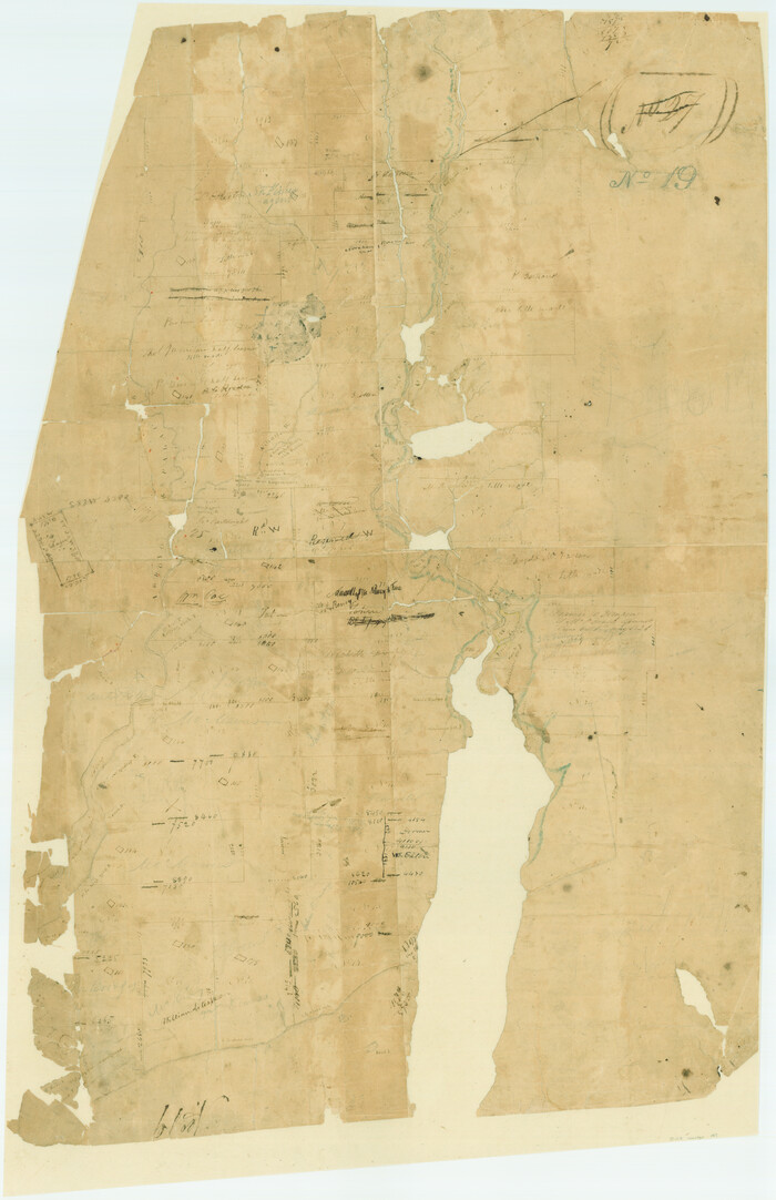
A Plat of the League of land surveyed on the south-west side of the Rio San Bernardo between it and the Bay-Prairie

Print $20.00
- Digital $50.00
A Plat of the League of land surveyed on the south-west side of the Rio San Bernardo between it and the Bay-Prairie
1831
Size: 37.3 x 24.0 inches
13
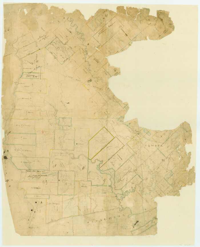
[Surveys in Austin's Colony at Matagorda Bay and along the Trespalacios and Colorado Rivers]
Print $20.00
- Digital $50.00
[Surveys in Austin's Colony at Matagorda Bay and along the Trespalacios and Colorado Rivers]
1821
Size: 31.6 x 20.5 inches
147
Brazoria County Sketch File 38

Print $40.00
- Digital $50.00
Brazoria County Sketch File 38
1917
Size: 17.1 x 14.5 inches
15043
Brazoria County Sketch File 39

Print $8.00
- Digital $50.00
Brazoria County Sketch File 39
1933
Size: 11.3 x 8.8 inches
15045
[Surveys in Austin's Colony on the east side of the Colorado River]
Print $20.00
- Digital $50.00
[Surveys in Austin's Colony on the east side of the Colorado River]
1830
Size: 30.9 x 25.1 inches
167
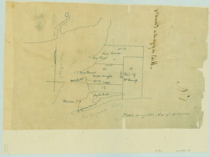
[Surveys on Trespalacios Bay]
Print $2.00
- Digital $50.00
[Surveys on Trespalacios Bay]
Size: 7.2 x 9.6 inches
19
Texas Gulf Coast, from the Sabine River to the Rio Grande as Subdivided for Mineral Development; Galveston, Brazoria and Matagorda Counties

Print $40.00
- Digital $50.00
Texas Gulf Coast, from the Sabine River to the Rio Grande as Subdivided for Mineral Development; Galveston, Brazoria and Matagorda Counties
1976
Size: 43.8 x 69.3 inches
1938
Texas Gulf Coast, from the Sabine River to the Rio Grande as Subdivided for Mineral Development; Matagorda, Calhoun and Aransas Counties

Print $40.00
- Digital $50.00
Texas Gulf Coast, from the Sabine River to the Rio Grande as Subdivided for Mineral Development; Matagorda, Calhoun and Aransas Counties
1976
Size: 43.0 x 90.9 inches
1939
Matagorda County Rolled Sketch 37A
Print $40.00
- Digital $50.00
Matagorda County Rolled Sketch 37A
-
Size
48.7 x 41.1 inches
-
Map/Doc
10195
Matagorda County Rolled Sketch 37C
Print $20.00
- Digital $50.00
Matagorda County Rolled Sketch 37C
-
Size
11.6 x 14.3 inches
-
Map/Doc
10197
Jackson County Sketch File 8
Print $20.00
- Digital $50.00
Jackson County Sketch File 8
-
Size
30.5 x 35.7 inches
-
Map/Doc
10503
Matagorda County Sketch File 32
Print $20.00
- Digital $50.00
Matagorda County Sketch File 32
1918
-
Size
36.5 x 30.4 inches
-
Map/Doc
10531
-
Creation Date
1918
Matagorda County Rolled Sketch 39
Print $40.00
- Digital $50.00
Matagorda County Rolled Sketch 39
1973
-
Size
24.4 x 114.0 inches
-
Map/Doc
10743
-
Creation Date
1973
Calhoun County Sketch File 1
Print $7.00
- Digital $50.00
Calhoun County Sketch File 1
1855
-
Size
17.1 x 11.0 inches
-
Map/Doc
11031
-
Creation Date
1855
Jackson County Sketch File 4
Print $20.00
- Digital $50.00
Jackson County Sketch File 4
-
Size
18.2 x 22.7 inches
-
Map/Doc
11834
Jackson County Sketch File 13
Print $40.00
- Digital $50.00
Jackson County Sketch File 13
-
Size
29.0 x 18.6 inches
-
Map/Doc
11839
Jackson County Sketch File 17
Print $20.00
- Digital $50.00
Jackson County Sketch File 17
1913
-
Size
19.4 x 19.1 inches
-
Map/Doc
11841
-
Creation Date
1913
Jackson County Sketch File 25
Print $20.00
- Digital $50.00
Jackson County Sketch File 25
1942
-
Size
15.4 x 37.4 inches
-
Map/Doc
11845
-
Creation Date
1942
Jackson County Sketch File 27
Print $20.00
- Digital $50.00
Jackson County Sketch File 27
1938
-
Size
25.6 x 24.8 inches
-
Map/Doc
11847
-
Creation Date
1938
Matagorda County Sketch File 7
Print $20.00
- Digital $50.00
Matagorda County Sketch File 7
1890
-
Size
37.3 x 24.6 inches
-
Map/Doc
12038
-
Creation Date
1890
Matagorda County Sketch File 13
Print $20.00
- Digital $50.00
Matagorda County Sketch File 13
1902
-
Size
21.5 x 19.0 inches
-
Map/Doc
12039
-
Creation Date
1902
Matagorda County Sketch File 17
Print $20.00
- Digital $50.00
Matagorda County Sketch File 17
1877
-
Size
16.4 x 14.5 inches
-
Map/Doc
12040
-
Creation Date
1877
Matagorda County Sketch File 25
Print $20.00
- Digital $50.00
Matagorda County Sketch File 25
1903
-
Size
18.1 x 30.3 inches
-
Map/Doc
12041
-
Creation Date
1903
Matagorda County Sketch File 29
Print $20.00
- Digital $50.00
Matagorda County Sketch File 29
1909
-
Size
33.4 x 27.9 inches
-
Map/Doc
12044
-
Creation Date
1909
Matagorda County Sketch File 30
Print $20.00
- Digital $50.00
Matagorda County Sketch File 30
1911
-
Size
22.2 x 31.9 inches
-
Map/Doc
12045
-
Creation Date
1911
Matagorda County Sketch File 38
Print $20.00
- Digital $50.00
Matagorda County Sketch File 38
1904
-
Size
24.4 x 33.0 inches
-
Map/Doc
12046
-
Creation Date
1904
Matagorda County Sketch File 39
Print $20.00
- Digital $50.00
Matagorda County Sketch File 39
-
Size
31.1 x 24.3 inches
-
Map/Doc
12047
Matagorda County Sketch File 40
Print $20.00
- Digital $50.00
Matagorda County Sketch File 40
-
Size
33.0 x 25.5 inches
-
Map/Doc
12048
Wharton County Sketch File 22
Print $20.00
- Digital $50.00
Wharton County Sketch File 22
1911
-
Size
20.1 x 15.4 inches
-
Map/Doc
12666
-
Creation Date
1911
Wharton County Sketch File A3
Print $26.00
- Digital $50.00
Wharton County Sketch File A3
1899
-
Size
18.2 x 18.6 inches
-
Map/Doc
12671
-
Creation Date
1899
A Plat of the League of land surveyed on the south-west side of the Rio San Bernardo between it and the Bay-Prairie
Print $20.00
- Digital $50.00
A Plat of the League of land surveyed on the south-west side of the Rio San Bernardo between it and the Bay-Prairie
1831
-
Size
37.3 x 24.0 inches
-
Map/Doc
13
-
Creation Date
1831
[Surveys in Austin's Colony at Matagorda Bay and along the Trespalacios and Colorado Rivers]
Print $20.00
- Digital $50.00
[Surveys in Austin's Colony at Matagorda Bay and along the Trespalacios and Colorado Rivers]
1821
-
Size
31.6 x 20.5 inches
-
Map/Doc
147
-
Creation Date
1821
Brazoria County Sketch File 38
Print $40.00
- Digital $50.00
Brazoria County Sketch File 38
1917
-
Size
17.1 x 14.5 inches
-
Map/Doc
15043
-
Creation Date
1917
Brazoria County Sketch File 39
Print $8.00
- Digital $50.00
Brazoria County Sketch File 39
1933
-
Size
11.3 x 8.8 inches
-
Map/Doc
15045
-
Creation Date
1933
[Surveys in Austin's Colony on the east side of the Colorado River]
Print $20.00
- Digital $50.00
[Surveys in Austin's Colony on the east side of the Colorado River]
1830
-
Size
30.9 x 25.1 inches
-
Map/Doc
167
-
Creation Date
1830
[Surveys on Trespalacios Bay]
Print $2.00
- Digital $50.00
[Surveys on Trespalacios Bay]
-
Size
7.2 x 9.6 inches
-
Map/Doc
19
Texas Gulf Coast, from the Sabine River to the Rio Grande as Subdivided for Mineral Development; Galveston, Brazoria and Matagorda Counties
Print $40.00
- Digital $50.00
Texas Gulf Coast, from the Sabine River to the Rio Grande as Subdivided for Mineral Development; Galveston, Brazoria and Matagorda Counties
1976
-
Size
43.8 x 69.3 inches
-
Map/Doc
1938
-
Creation Date
1976
Texas Gulf Coast, from the Sabine River to the Rio Grande as Subdivided for Mineral Development; Matagorda, Calhoun and Aransas Counties
Print $40.00
- Digital $50.00
Texas Gulf Coast, from the Sabine River to the Rio Grande as Subdivided for Mineral Development; Matagorda, Calhoun and Aransas Counties
1976
-
Size
43.0 x 90.9 inches
-
Map/Doc
1939
-
Creation Date
1976