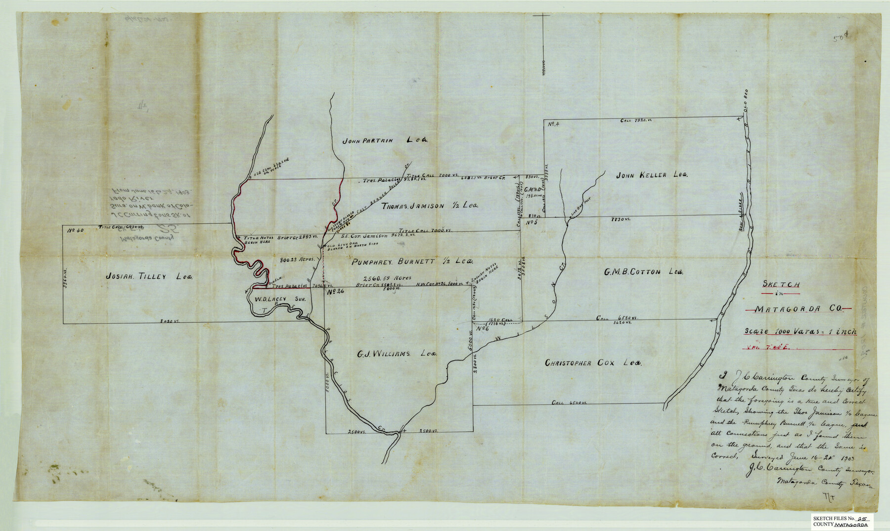
Matagorda County Sketch File 25
[Sketch between Tres Palacios and Colorado Rivers]
-
Map/Doc
12041
-
Collection
General Map Collection
-
Object Dates
6/24/1903 (Creation Date)
-
People and Organizations
J.C. Carrington (Surveyor/Engineer)
-
Counties
Matagorda
-
Subjects
Surveying Sketch File
-
Height x Width
18.1 x 30.3 inches
46.0 x 77.0 cm
-
Medium
paper, manuscript
-
Features
East Branch of Briers Creek
Wilson Creek
Colorado River
Tres Palacios River
Brier's Creek
Part of: General Map Collection
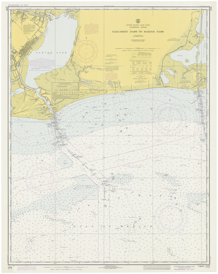
Calcasieu Pass to Sabine Pass
Print $20.00
- Digital $50.00
Calcasieu Pass to Sabine Pass
1973
Size 44.8 x 35.6 inches
Map/Doc 69812
Padre Island National Seashore, Texas - Dependent Resurvey

Print $4.00
- Digital $50.00
Padre Island National Seashore, Texas - Dependent Resurvey
2001
Size 17.9 x 24.0 inches
Map/Doc 60550
Wilbarger County Sketch File 21

Print $4.00
- Digital $50.00
Wilbarger County Sketch File 21
1889
Size 11.1 x 8.6 inches
Map/Doc 40219
Kaufman County State Real Property Sketch 1

Print $92.00
- Digital $50.00
Kaufman County State Real Property Sketch 1
2006
Size 24.6 x 35.4 inches
Map/Doc 88624
Young County Sketch File 13

Print $4.00
- Digital $50.00
Young County Sketch File 13
1891
Size 8.3 x 10.0 inches
Map/Doc 40878
Brazos River, Fresno Sheet

Print $20.00
- Digital $50.00
Brazos River, Fresno Sheet
1938
Size 31.3 x 38.4 inches
Map/Doc 65289
Orange County Sketch File 38

Print $6.00
- Digital $50.00
Orange County Sketch File 38
1954
Size 14.3 x 8.7 inches
Map/Doc 33378
Oldham County Working Sketch 1

Print $20.00
- Digital $50.00
Oldham County Working Sketch 1
1901
Size 40.2 x 24.7 inches
Map/Doc 71323
Ward County Working Sketch 21

Print $20.00
- Digital $50.00
Ward County Working Sketch 21
1953
Size 20.9 x 14.7 inches
Map/Doc 72327

Glasscock County Sketch File 18

Print $8.00
- Digital $50.00
Glasscock County Sketch File 18
1931
Size 9.7 x 6.2 inches
Map/Doc 24192
Upton County Sketch File 17

Print $6.00
- Digital $50.00
Upton County Sketch File 17
Size 11.0 x 10.9 inches
Map/Doc 38875
You may also like
Morris County Rolled Sketch 2A

Print $20.00
- Digital $50.00
Morris County Rolled Sketch 2A
Size 24.0 x 18.7 inches
Map/Doc 10280
Fractional Township No. 8 South Range No. 3 East of the Indian Meridian, Indian Territory

Print $20.00
- Digital $50.00
Fractional Township No. 8 South Range No. 3 East of the Indian Meridian, Indian Territory
1898
Size 19.2 x 24.4 inches
Map/Doc 75205
Cameron County Sketch File 12

Print $222.00
- Digital $50.00
Cameron County Sketch File 12
Size 10.8 x 7.4 inches
Map/Doc 17236
Hartley County Sketch File 10

Print $57.00
- Digital $50.00
Hartley County Sketch File 10
Size 9.2 x 7.8 inches
Map/Doc 26099
Marion County Working Sketch 41

Print $40.00
- Digital $50.00
Marion County Working Sketch 41
1996
Size 34.0 x 48.5 inches
Map/Doc 70817
Harris County NRC Article 33.136 Sketch 4

Print $22.00
- Digital $50.00
Harris County NRC Article 33.136 Sketch 4
2001
Size 36.1 x 24.3 inches
Map/Doc 61600
Map of [Coleman County]
![3413, Map of [Coleman County], General Map Collection](https://historictexasmaps.com/wmedia_w700/maps/3413-1.tif.jpg)
Print $20.00
- Digital $50.00
Map of [Coleman County]
1878
Size 24.9 x 21.9 inches
Map/Doc 3413
[Floyd County School Land Lgs. 180-183, Fisher County School Land Lgs. 105-108, and part of Blk. V]
![90192, [Floyd County School Land Lgs. 180-183, Fisher County School Land Lgs. 105-108, and part of Blk. V], Twichell Survey Records](https://historictexasmaps.com/wmedia_w700/maps/90192-1.tif.jpg)
Print $2.00
- Digital $50.00
[Floyd County School Land Lgs. 180-183, Fisher County School Land Lgs. 105-108, and part of Blk. V]
Size 8.7 x 10.2 inches
Map/Doc 90192
Webb County Working Sketch 14

Print $20.00
- Digital $50.00
Webb County Working Sketch 14
1923
Size 19.3 x 32.2 inches
Map/Doc 72379
Webb County Working Sketch 26

Print $20.00
- Digital $50.00
Webb County Working Sketch 26
1931
Size 17.9 x 18.4 inches
Map/Doc 72391
Upshur County Working Sketch 17

Print $40.00
- Digital $50.00
Upshur County Working Sketch 17
1997
Size 48.4 x 37.1 inches
Map/Doc 69575
General Highway Map, Gregg County, Texas

Print $20.00
General Highway Map, Gregg County, Texas
1961
Size 18.1 x 24.7 inches
Map/Doc 79488