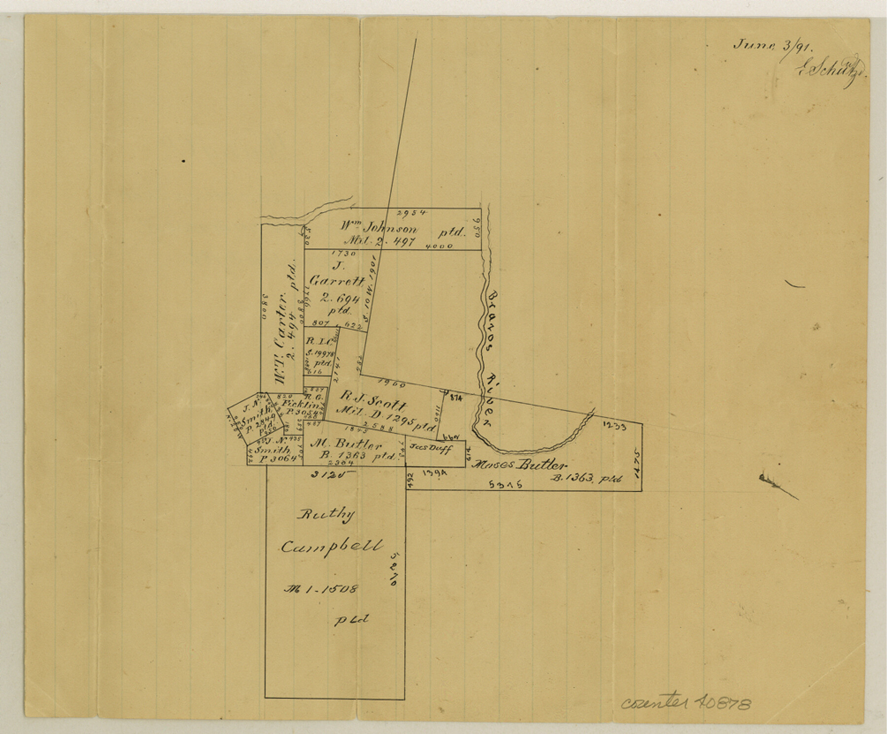
Young County Sketch File 13
[Office sketch of surveys in Brazos River]
-
Map/Doc
40878
-
Collection
General Map Collection
-
Object Dates
1891/6/3 (Creation Date)
1891/6/3 (File Date)
1891/6/3 (Creation Date)
-
People and Organizations
E. Schutze (Draftsman)
-
Counties
Young
-
Subjects
Surveying Sketch File
-
Height x Width
8.3 x 10.0 inches
21.1 x 25.4 cm
-
Medium
paper, manuscript
-
Features
Brazos River
Part of: General Map Collection
Flight Mission No. CRC-5R, Frame 22, Chambers County

Print $20.00
- Digital $50.00
Flight Mission No. CRC-5R, Frame 22, Chambers County
1956
Size 18.7 x 22.6 inches
Map/Doc 84944
Jeff Davis County Sketch File 8

Print $20.00
- Digital $50.00
Jeff Davis County Sketch File 8
1889
Size 19.5 x 28.5 inches
Map/Doc 11857
Duval County Sketch File 72

Print $6.00
- Digital $50.00
Duval County Sketch File 72
Size 10.4 x 8.6 inches
Map/Doc 21460
Hockley County Working Sketch 1

Print $40.00
- Digital $50.00
Hockley County Working Sketch 1
1946
Size 26.0 x 60.9 inches
Map/Doc 66191
Topographic and Road Map, Travis County

Print $40.00
- Digital $50.00
Topographic and Road Map, Travis County
1932
Size 37.5 x 48.2 inches
Map/Doc 4673
Val Verde County Sketch File Z12

Print $4.00
- Digital $50.00
Val Verde County Sketch File Z12
1898
Size 11.4 x 8.8 inches
Map/Doc 39140
Dimmit County Working Sketch 42

Print $20.00
- Digital $50.00
Dimmit County Working Sketch 42
1977
Size 33.5 x 39.6 inches
Map/Doc 68703
Calhoun County Sketch File 19

Print $70.00
- Digital $50.00
Calhoun County Sketch File 19
1998
Size 11.1 x 8.1 inches
Map/Doc 35992
A Map of the Republic of Texas and the adjacent territories, indicating the grants of land conceded under the empresario system of Mexico

Print $20.00
- Digital $50.00
A Map of the Republic of Texas and the adjacent territories, indicating the grants of land conceded under the empresario system of Mexico
1841
Size 13.8 x 16.6 inches
Map/Doc 93752
Jack County Working Sketch 5

Print $20.00
- Digital $50.00
Jack County Working Sketch 5
1952
Size 25.7 x 22.1 inches
Map/Doc 66431
Frio County Rolled Sketch 21

Print $20.00
- Digital $50.00
Frio County Rolled Sketch 21
1961
Size 43.8 x 27.7 inches
Map/Doc 8911
Live Oak County Boundary File 60a

Print $18.00
- Digital $50.00
Live Oak County Boundary File 60a
Size 12.7 x 8.4 inches
Map/Doc 56407
You may also like
Crane County Sketch File 18

Print $20.00
- Digital $50.00
Crane County Sketch File 18
1927
Size 15.1 x 18.4 inches
Map/Doc 11210
Angelina County Sketch File 16

Print $11.00
- Digital $50.00
Angelina County Sketch File 16
Size 7.9 x 3.8 inches
Map/Doc 13004
Wheeler County Boundary File 1

Print $24.00
- Digital $50.00
Wheeler County Boundary File 1
Size 14.4 x 8.7 inches
Map/Doc 59856
Brewster County Working Sketch 119

Print $20.00
- Digital $50.00
Brewster County Working Sketch 119
1909
Size 29.3 x 29.0 inches
Map/Doc 67719
No. 3 Chart of Channel connecting Corpus Christi Bay with Aransas Bay, Texas

Print $20.00
- Digital $50.00
No. 3 Chart of Channel connecting Corpus Christi Bay with Aransas Bay, Texas
1878
Size 18.3 x 27.9 inches
Map/Doc 72779
Hood County Working Sketch 32

Print $20.00
- Digital $50.00
Hood County Working Sketch 32
2004
Size 28.5 x 35.6 inches
Map/Doc 83573
Flight Mission No. DQN-3K, Frame 32, Calhoun County

Print $20.00
- Digital $50.00
Flight Mission No. DQN-3K, Frame 32, Calhoun County
1953
Size 18.6 x 22.3 inches
Map/Doc 84345
Bee County Boundary File 8

Print $52.00
- Digital $50.00
Bee County Boundary File 8
Size 9.2 x 7.8 inches
Map/Doc 50464
H No. 4 - Horn Island Pass, Mississippi Sound

Print $20.00
- Digital $50.00
H No. 4 - Horn Island Pass, Mississippi Sound
1852
Size 14.9 x 19.0 inches
Map/Doc 97225
[Blocks C4, S1, K and C3 in Northern Hale/Southern Swisher Counties]
![91858, [Blocks C4, S1, K and C3 in Northern Hale/Southern Swisher Counties], Twichell Survey Records](https://historictexasmaps.com/wmedia_w700/maps/91858-1.tif.jpg)
Print $2.00
- Digital $50.00
[Blocks C4, S1, K and C3 in Northern Hale/Southern Swisher Counties]
1906
Size 15.0 x 8.7 inches
Map/Doc 91858
Brown County Working Sketch 17

Print $20.00
- Digital $50.00
Brown County Working Sketch 17
1993
Size 25.6 x 29.4 inches
Map/Doc 67782
[Movements & Objectives of the 143rd & 144th Infantry on October 13, 1918, Appendix L]
![94124, [Movements & Objectives of the 143rd & 144th Infantry on October 13, 1918, Appendix L], Non-GLO Digital Images](https://historictexasmaps.com/wmedia_w700/maps/94124-1.tif.jpg)
Print $20.00
[Movements & Objectives of the 143rd & 144th Infantry on October 13, 1918, Appendix L]
1918
Size 16.1 x 16.8 inches
Map/Doc 94124