Foard County Sketch File 2

Print $40.00
- Digital $50.00
Foard County Sketch File 2
Size: 23.8 x 16.3 inches
11490
Palo Pinto County Sketch File 1

Print $20.00
- Digital $50.00
Palo Pinto County Sketch File 1
Size: 18.8 x 23.5 inches
12131
Palo Pinto County Sketch File 21

Print $20.00
- Digital $50.00
Palo Pinto County Sketch File 21
1896
Size: 18.5 x 17.5 inches
12133
Stephens County Sketch File 1B

Print $20.00
- Digital $50.00
Stephens County Sketch File 1B
Size: 12.9 x 28.2 inches
12348
Young County Sketch File 8

Print $20.00
- Digital $50.00
Young County Sketch File 8
1856
Size: 19.8 x 17.7 inches
12710
Young County Sketch File 10

Print $20.00
- Digital $50.00
Young County Sketch File 10
Size: 14.1 x 17.7 inches
12711
Young County Sketch File 14

Print $20.00
- Digital $50.00
Young County Sketch File 14
1895
Size: 10.9 x 27.3 inches
12712
Young County Sketch File 17

Print $20.00
- Digital $50.00
Young County Sketch File 17
Size: 18.5 x 24.3 inches
12713
Young County Sketch File 20

Print $20.00
- Digital $50.00
Young County Sketch File 20
1922
Size: 27.4 x 23.9 inches
12714
Young County Sketch File 21

Print $20.00
- Digital $50.00
Young County Sketch File 21
1954
Size: 19.0 x 23.0 inches
12715
Young County Sketch File 22

Print $20.00
- Digital $50.00
Young County Sketch File 22
1957
Size: 22.9 x 19.8 inches
12716
Map of The Surveyed Part of Peters Colony Texas

Print $40.00
- Digital $50.00
Map of The Surveyed Part of Peters Colony Texas
1854
Size: 53.5 x 65.9 inches
1967
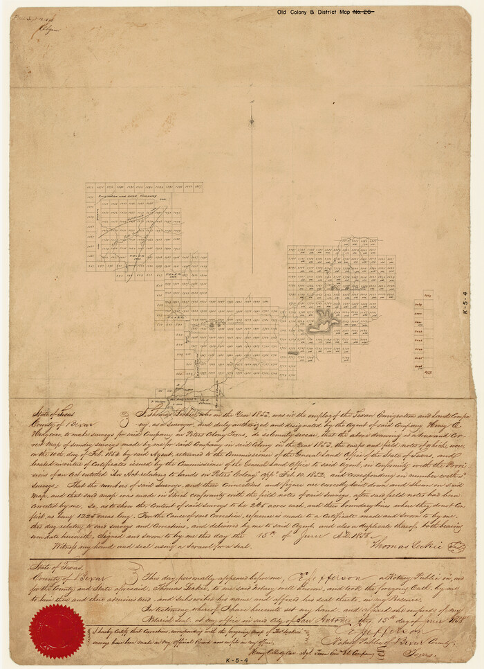
[Surveys made in Peters Colony by Thomas Leckie]
Print $20.00
- Digital $50.00
[Surveys made in Peters Colony by Thomas Leckie]
1858
Size: 22.9 x 16.6 inches
1983
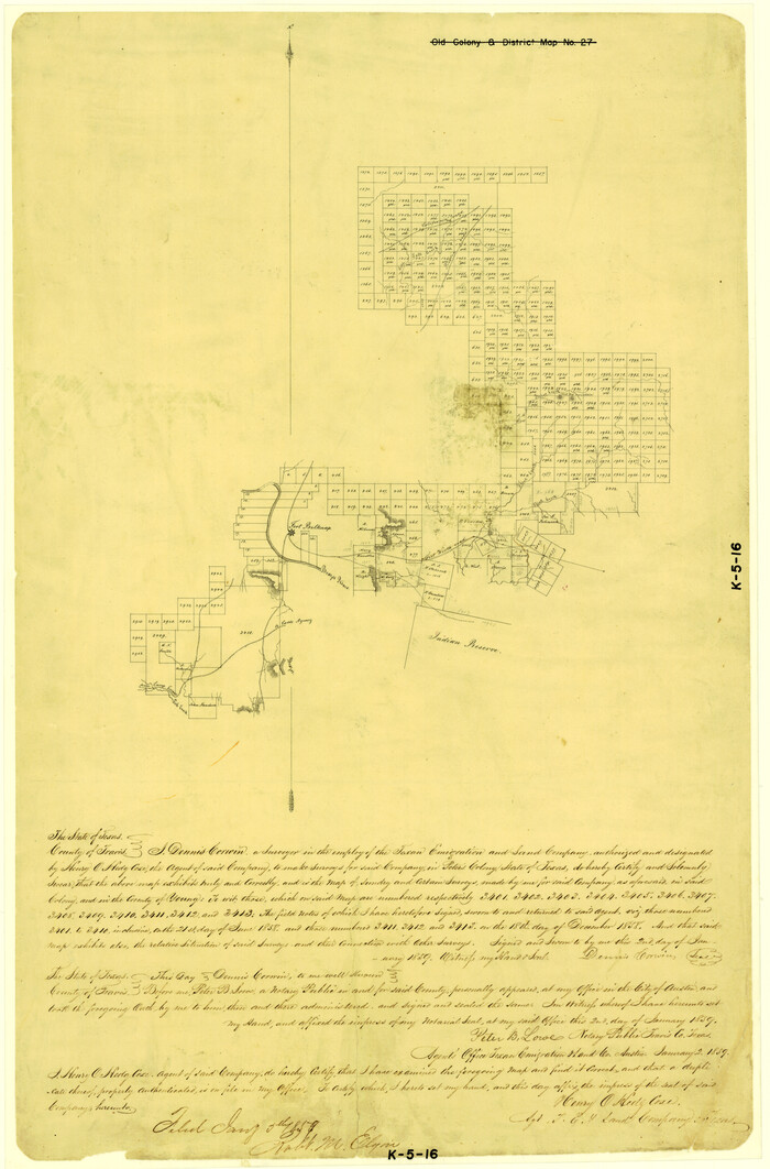
[Surveys made in Peters Colony by Dennis Corwin]
Print $20.00
- Digital $50.00
[Surveys made in Peters Colony by Dennis Corwin]
1859
Size: 24.6 x 16.2 inches
1985
Haskell County Sketch File 16

Print $32.00
- Digital $50.00
Haskell County Sketch File 16
1894
Size: 11.2 x 8.8 inches
26163
Jack County Sketch File 13

Print $4.00
- Digital $50.00
Jack County Sketch File 13
Size: 10.3 x 8.0 inches
27537
Palo Pinto County Sketch File 2

Print $4.00
- Digital $50.00
Palo Pinto County Sketch File 2
1857
Size: 8.2 x 10.3 inches
33392
Palo Pinto County Sketch File 20

Print $6.00
- Digital $50.00
Palo Pinto County Sketch File 20
1891
Size: 12.5 x 10.9 inches
33402
Stephens County Sketch File 17

Print $6.00
- Digital $50.00
Stephens County Sketch File 17
1912
Size: 11.2 x 8.7 inches
37074
Young County Sketch File 1

Print $8.00
- Digital $50.00
Young County Sketch File 1
1853
Size: 7.9 x 9.7 inches
40843
Young County Sketch File 3

Print $4.00
- Digital $50.00
Young County Sketch File 3
1854
Size: 12.3 x 8.2 inches
40847
Young County Sketch File 4

Print $6.00
- Digital $50.00
Young County Sketch File 4
1852
Size: 5.3 x 4.3 inches
40849
Young County Sketch File 6

Print $14.00
- Digital $50.00
Young County Sketch File 6
Size: 13.0 x 8.2 inches
40852
Young County Sketch File 7

Print $6.00
- Digital $50.00
Young County Sketch File 7
1856
Size: 8.4 x 9.2 inches
40859
Young County Sketch File 8a

Print $4.00
- Digital $50.00
Young County Sketch File 8a
1858
Size: 9.8 x 8.0 inches
40862
Young County Sketch File 9

Print $4.00
- Digital $50.00
Young County Sketch File 9
1859
Size: 8.5 x 7.8 inches
40864
Young County Sketch File 9a

Print $4.00
- Digital $50.00
Young County Sketch File 9a
1875
Size: 12.9 x 8.3 inches
40866
Young County Sketch File 10a

Print $4.00
- Digital $50.00
Young County Sketch File 10a
1879
Size: 8.0 x 7.5 inches
40868
Young County Sketch File 10b

Print $4.00
- Digital $50.00
Young County Sketch File 10b
1880
Size: 12.9 x 8.4 inches
40870
Foard County Sketch File 2
Print $40.00
- Digital $50.00
Foard County Sketch File 2
-
Size
23.8 x 16.3 inches
-
Map/Doc
11490
Palo Pinto County Sketch File 1
Print $20.00
- Digital $50.00
Palo Pinto County Sketch File 1
-
Size
18.8 x 23.5 inches
-
Map/Doc
12131
Palo Pinto County Sketch File 21
Print $20.00
- Digital $50.00
Palo Pinto County Sketch File 21
1896
-
Size
18.5 x 17.5 inches
-
Map/Doc
12133
-
Creation Date
1896
Stephens County Sketch File 1B
Print $20.00
- Digital $50.00
Stephens County Sketch File 1B
-
Size
12.9 x 28.2 inches
-
Map/Doc
12348
Young County Sketch File 8
Print $20.00
- Digital $50.00
Young County Sketch File 8
1856
-
Size
19.8 x 17.7 inches
-
Map/Doc
12710
-
Creation Date
1856
Young County Sketch File 10
Print $20.00
- Digital $50.00
Young County Sketch File 10
-
Size
14.1 x 17.7 inches
-
Map/Doc
12711
Young County Sketch File 14
Print $20.00
- Digital $50.00
Young County Sketch File 14
1895
-
Size
10.9 x 27.3 inches
-
Map/Doc
12712
-
Creation Date
1895
Young County Sketch File 17
Print $20.00
- Digital $50.00
Young County Sketch File 17
-
Size
18.5 x 24.3 inches
-
Map/Doc
12713
Young County Sketch File 20
Print $20.00
- Digital $50.00
Young County Sketch File 20
1922
-
Size
27.4 x 23.9 inches
-
Map/Doc
12714
-
Creation Date
1922
Young County Sketch File 21
Print $20.00
- Digital $50.00
Young County Sketch File 21
1954
-
Size
19.0 x 23.0 inches
-
Map/Doc
12715
-
Creation Date
1954
Young County Sketch File 22
Print $20.00
- Digital $50.00
Young County Sketch File 22
1957
-
Size
22.9 x 19.8 inches
-
Map/Doc
12716
-
Creation Date
1957
Milam [District]
![1948, Milam [District], General Map Collection](https://historictexasmaps.com/wmedia_w700/maps/1948.tif.jpg)
Print $40.00
- Digital $50.00
Milam [District]
1850
-
Size
60.8 x 46.4 inches
-
Map/Doc
1948
-
Creation Date
1850
Map of The Surveyed Part of Peters Colony Texas
Print $40.00
- Digital $50.00
Map of The Surveyed Part of Peters Colony Texas
1854
-
Size
53.5 x 65.9 inches
-
Map/Doc
1967
-
Creation Date
1854
[Surveys made in Peters Colony by Thomas Leckie]
Print $20.00
- Digital $50.00
[Surveys made in Peters Colony by Thomas Leckie]
1858
-
Size
22.9 x 16.6 inches
-
Map/Doc
1983
-
Creation Date
1858
[Surveys made in Peters Colony by Dennis Corwin]
Print $20.00
- Digital $50.00
[Surveys made in Peters Colony by Dennis Corwin]
1859
-
Size
24.6 x 16.2 inches
-
Map/Doc
1985
-
Creation Date
1859
Haskell County Sketch File 16
Print $32.00
- Digital $50.00
Haskell County Sketch File 16
1894
-
Size
11.2 x 8.8 inches
-
Map/Doc
26163
-
Creation Date
1894
Jack County Sketch File 13
Print $4.00
- Digital $50.00
Jack County Sketch File 13
-
Size
10.3 x 8.0 inches
-
Map/Doc
27537
Palo Pinto County Sketch File 2
Print $4.00
- Digital $50.00
Palo Pinto County Sketch File 2
1857
-
Size
8.2 x 10.3 inches
-
Map/Doc
33392
-
Creation Date
1857
Palo Pinto County Sketch File 20
Print $6.00
- Digital $50.00
Palo Pinto County Sketch File 20
1891
-
Size
12.5 x 10.9 inches
-
Map/Doc
33402
-
Creation Date
1891
Stephens County Sketch File 17
Print $6.00
- Digital $50.00
Stephens County Sketch File 17
1912
-
Size
11.2 x 8.7 inches
-
Map/Doc
37074
-
Creation Date
1912
Young County Sketch File 1
Print $8.00
- Digital $50.00
Young County Sketch File 1
1853
-
Size
7.9 x 9.7 inches
-
Map/Doc
40843
-
Creation Date
1853
Young County Sketch File 3
Print $4.00
- Digital $50.00
Young County Sketch File 3
1854
-
Size
12.3 x 8.2 inches
-
Map/Doc
40847
-
Creation Date
1854
Young County Sketch File 4
Print $6.00
- Digital $50.00
Young County Sketch File 4
1852
-
Size
5.3 x 4.3 inches
-
Map/Doc
40849
-
Creation Date
1852
Young County Sketch File 6
Print $14.00
- Digital $50.00
Young County Sketch File 6
-
Size
13.0 x 8.2 inches
-
Map/Doc
40852
Young County Sketch File 7
Print $6.00
- Digital $50.00
Young County Sketch File 7
1856
-
Size
8.4 x 9.2 inches
-
Map/Doc
40859
-
Creation Date
1856
Young County Sketch File 8a
Print $4.00
- Digital $50.00
Young County Sketch File 8a
1858
-
Size
9.8 x 8.0 inches
-
Map/Doc
40862
-
Creation Date
1858
Young County Sketch File 9
Print $4.00
- Digital $50.00
Young County Sketch File 9
1859
-
Size
8.5 x 7.8 inches
-
Map/Doc
40864
-
Creation Date
1859
Young County Sketch File 9a
Print $4.00
- Digital $50.00
Young County Sketch File 9a
1875
-
Size
12.9 x 8.3 inches
-
Map/Doc
40866
-
Creation Date
1875
Young County Sketch File 10a
Print $4.00
- Digital $50.00
Young County Sketch File 10a
1879
-
Size
8.0 x 7.5 inches
-
Map/Doc
40868
-
Creation Date
1879
Young County Sketch File 10b
Print $4.00
- Digital $50.00
Young County Sketch File 10b
1880
-
Size
12.9 x 8.4 inches
-
Map/Doc
40870
-
Creation Date
1880