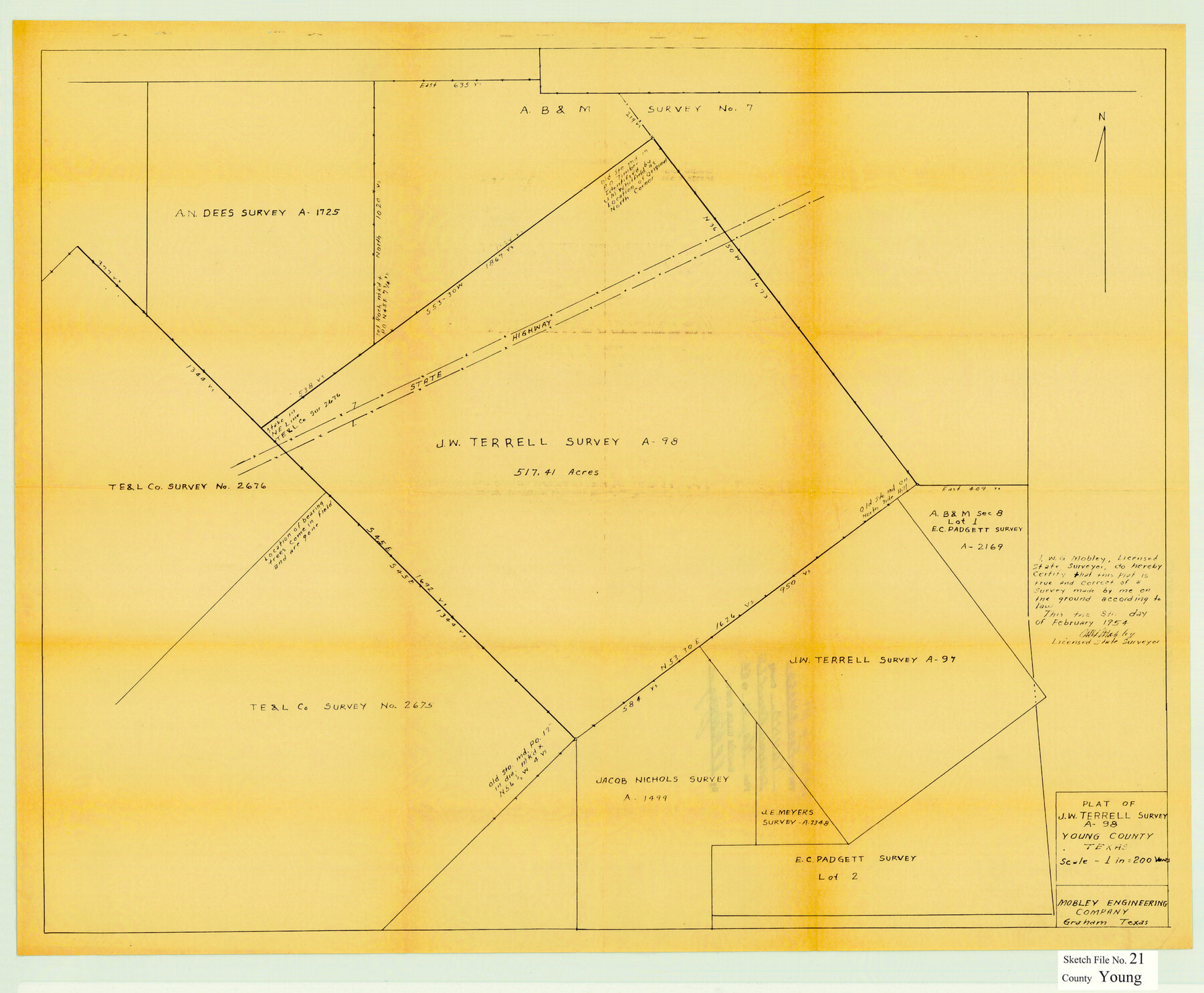
Young County Sketch File 21
Plat of J. W. Terrell Survey A-98 Young County Texas
-
Map/Doc
12715
-
Collection
General Map Collection
-
Object Dates
1954/2/8 (Creation Date)
1954/5/11 (File Date)
1954/2/8 (Creation Date)
-
People and Organizations
W.G. Mobley (Surveyor/Engineer)
-
Counties
Young
-
Subjects
Cadastral Surveying Sketch File
-
Height x Width
19.0 x 23.0 inches
48.3 x 58.4 cm
-
Medium
blueprint/diazo
Part of: General Map Collection
Ector County Working Sketch 28
![68871, Ector County Working Sketch 28, General Map Collection](https://historictexasmaps.com/wmedia_w700/maps/68871.tif.jpg)
Print $40.00
- Digital $50.00
Ector County Working Sketch 28
Size 43.3 x 61.6 inches
Map/Doc 68871
Navarro County Sketch File 9
![32317, Navarro County Sketch File 9, General Map Collection](https://historictexasmaps.com/wmedia_w700/pdf_converted_jpg/qi_pdf_thumbnail_13267.jpg)
Print $2.00
- Digital $50.00
Navarro County Sketch File 9
Size 8.3 x 9.1 inches
Map/Doc 32317
Throckmorton County Sketch File 2
![12431, Throckmorton County Sketch File 2, General Map Collection](https://historictexasmaps.com/wmedia_w700/pdf_converted_jpg/qi_pdf_thumbnail_8722.jpg)
Print $20.00
- Digital $50.00
Throckmorton County Sketch File 2
Size 22.1 x 26.2 inches
Map/Doc 12431
[Portion of Harris County]
![78482, [Portion of Harris County], General Map Collection](https://historictexasmaps.com/wmedia_w700/maps/78482.tif.jpg)
Print $2.00
- Digital $50.00
[Portion of Harris County]
Size 9.8 x 7.2 inches
Map/Doc 78482
Cottle County Sketch File F
![19444, Cottle County Sketch File F, General Map Collection](https://historictexasmaps.com/wmedia_w700/pdf_converted_jpg/qi_pdf_thumbnail_10421.jpg)
Print $6.00
- Digital $50.00
Cottle County Sketch File F
1935
Size 11.5 x 8.8 inches
Map/Doc 19444
Cameron County NRC Article 33.136 Sketch 5
![95724, Cameron County NRC Article 33.136 Sketch 5, General Map Collection](https://historictexasmaps.com/wmedia_w700/pdf_converted_jpg/qi_pdf_thumbnail_39683.jpg)
Print $202.00
- Digital $50.00
Cameron County NRC Article 33.136 Sketch 5
2018
Size 24.3 x 36.1 inches
Map/Doc 95724
Upton County Working Sketch 1
![69497, Upton County Working Sketch 1, General Map Collection](https://historictexasmaps.com/wmedia_w700/maps/69497.tif.jpg)
Print $20.00
- Digital $50.00
Upton County Working Sketch 1
Size 11.6 x 20.0 inches
Map/Doc 69497
Montgomery County Working Sketch Graphic Index, Sheet 1 (Sketches 1 to 35)
![76646, Montgomery County Working Sketch Graphic Index, Sheet 1 (Sketches 1 to 35), General Map Collection](https://historictexasmaps.com/wmedia_w700/maps/76646.tif.jpg)
Print $40.00
- Digital $50.00
Montgomery County Working Sketch Graphic Index, Sheet 1 (Sketches 1 to 35)
1943
Size 43.0 x 51.9 inches
Map/Doc 76646
Blanco County Sketch File 37
![14646, Blanco County Sketch File 37, General Map Collection](https://historictexasmaps.com/wmedia_w700/pdf_converted_jpg/qi_pdf_thumbnail_9455.jpg)
Print $4.00
- Digital $50.00
Blanco County Sketch File 37
Size 8.7 x 14.1 inches
Map/Doc 14646
Crockett County Rolled Sketch 67
![5610, Crockett County Rolled Sketch 67, General Map Collection](https://historictexasmaps.com/wmedia_w700/maps/5610.tif.jpg)
Print $20.00
- Digital $50.00
Crockett County Rolled Sketch 67
1948
Size 34.2 x 21.7 inches
Map/Doc 5610
Foard County Aerial Photograph Index Sheet 4
![83691, Foard County Aerial Photograph Index Sheet 4, General Map Collection](https://historictexasmaps.com/wmedia_w700/pdf_converted_jpg/qi_pdf_thumbnail_30912.jpg)
Print $20.00
- Digital $50.00
Foard County Aerial Photograph Index Sheet 4
1950
Size 18.6 x 16.3 inches
Map/Doc 83691
Gaines County Working Sketch 24
![69324, Gaines County Working Sketch 24, General Map Collection](https://historictexasmaps.com/wmedia_w700/maps/69324.tif.jpg)
Print $20.00
- Digital $50.00
Gaines County Working Sketch 24
Size 36.4 x 37.9 inches
Map/Doc 69324
You may also like
Township 11 North Range 15 West, Western District, Louisiana
![65870, Township 11 North Range 15 West, Western District, Louisiana, General Map Collection](https://historictexasmaps.com/wmedia_w700/maps/65870.tif.jpg)
Print $20.00
- Digital $50.00
Township 11 North Range 15 West, Western District, Louisiana
1834
Size 19.7 x 24.6 inches
Map/Doc 65870
Hudspeth County Working Sketch 45
![66330, Hudspeth County Working Sketch 45, General Map Collection](https://historictexasmaps.com/wmedia_w700/maps/66330-1.tif.jpg)
Print $20.00
- Digital $50.00
Hudspeth County Working Sketch 45
Size 34.7 x 43.2 inches
Map/Doc 66330
A Topographical Map of The Government Tract Adjoining the City of Austin
![82031, A Topographical Map of The Government Tract Adjoining the City of Austin, General Map Collection](https://historictexasmaps.com/wmedia_w700/maps/82031.tif.jpg)
Print $20.00
- Digital $50.00
A Topographical Map of The Government Tract Adjoining the City of Austin
1840
Size 44.5 x 36.0 inches
Map/Doc 82031
Reagan County Sketch File 15
![35000, Reagan County Sketch File 15, General Map Collection](https://historictexasmaps.com/wmedia_w700/pdf_converted_jpg/qi_pdf_thumbnail_13809.jpg)
Print $4.00
- Digital $50.00
Reagan County Sketch File 15
1931
Size 8.0 x 13.3 inches
Map/Doc 35000
San Antonio - Places of Interest and how to get there
![San Antonio - Places of Interest and how to get there](https://historictexasmaps.com/wmedia_w700/pdf_converted_jpg/qi_pdf_thumbnail_64316.jpg)
San Antonio - Places of Interest and how to get there
1920
Map/Doc 96785
Wise County Sketch File 46
![12701, Wise County Sketch File 46, General Map Collection](https://historictexasmaps.com/wmedia_w700/pdf_converted_jpg/qi_pdf_thumbnail_8962.jpg)
Print $20.00
- Digital $50.00
Wise County Sketch File 46
Size 24.7 x 18.5 inches
Map/Doc 12701
Johnson County Rolled Sketch 4
![94047, Johnson County Rolled Sketch 4, General Map Collection](https://historictexasmaps.com/wmedia_w700/maps/94047.tif.jpg)
Print $20.00
- Digital $50.00
Johnson County Rolled Sketch 4
Size 24.8 x 36.0 inches
Map/Doc 94047
Map of Texas, compiled from surveys on record in the General Land Office of the Republic
![93858, Map of Texas, compiled from surveys on record in the General Land Office of the Republic, Holcomb Digital Map Collection](https://historictexasmaps.com/wmedia_w700/maps/93858.tif.jpg)
Print $20.00
- Digital $50.00
Map of Texas, compiled from surveys on record in the General Land Office of the Republic
1839
Size 33.0 x 25.3 inches
Map/Doc 93858
Preliminary Chart of the Sea Coast of Texas in the Vicinity of Galveston
![76256, Preliminary Chart of the Sea Coast of Texas in the Vicinity of Galveston, Texas State Library and Archives](https://historictexasmaps.com/wmedia_w700/maps/76256.tif.jpg)
Print $20.00
Preliminary Chart of the Sea Coast of Texas in the Vicinity of Galveston
1856
Size 26.3 x 19.7 inches
Map/Doc 76256
Armstrong County Working Sketch 5
![67236, Armstrong County Working Sketch 5, General Map Collection](https://historictexasmaps.com/wmedia_w700/maps/67236.tif.jpg)
Print $40.00
- Digital $50.00
Armstrong County Working Sketch 5
1918
Size 48.4 x 41.9 inches
Map/Doc 67236
Webb County Working Sketch 94
![72461, Webb County Working Sketch 94, General Map Collection](https://historictexasmaps.com/wmedia_w700/maps/72461.tif.jpg)
Print $20.00
- Digital $50.00
Webb County Working Sketch 94
Size 23.1 x 25.6 inches
Map/Doc 72461