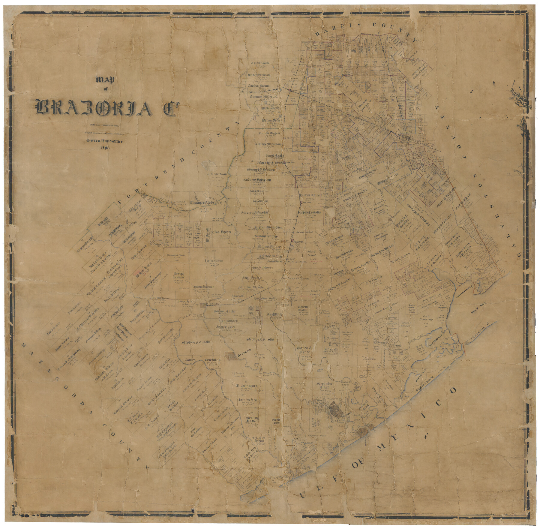
Map of Brazoria County
-
Map/Doc
16945
-
Collection
General Map Collection
-
Object Dates
1891 (Creation Date)
-
People and Organizations
Schutze (Draftsman)
-
Counties
Brazoria
-
Subjects
County
-
Height x Width
56.9 x 58.4 inches
144.5 x 148.3 cm
-
Comments
Conservation funded by Friends of the Texas General Land Office in 2003.
Digitized in 2012 with a generous grant from the Summerlee Foundation. -
Features
Oyster Bay
Varner's Creek
Columbia
Chocolate Bay
West Bay
North Creek
Oyster Creek
Bastrop Bayou
Bastrop Bay
Mudd [sic] Island
Galveston Island
Buffalo Creek
Brazoria
Mustang Bayou
Gulf of Mexico
Orum Point
Matagorda Bay
Jones Creek
Velasco
East Union Bayou
[Oyster Creek] Canal
Quintana
West Union Bayou
Cedar Lake Bayou
Cedar Lake
Flores Bayou
China Grove
Flat Bank Bayou
Ariola
Long Point Creek
Clear Lake
Mill Lake
GC&SF
Mustang
Cow Bayou
Big Lake
Alvin
Sandy Point
Bee Creek
Clear Creek
Liverpool
Brazos River
Cow Creek
Mound Creek
I&GN
Halls Bayou
Chenango
San Bernardo River
Austin Bayou
Chocolate Bayou
New Creek
Part of: General Map Collection
Flight Mission No. DIX-3P, Frame 139, Aransas County

Print $20.00
- Digital $50.00
Flight Mission No. DIX-3P, Frame 139, Aransas County
1956
Size 17.8 x 18.6 inches
Map/Doc 83769
Motley County Working Sketch 6

Print $20.00
- Digital $50.00
Motley County Working Sketch 6
1963
Size 17.6 x 29.3 inches
Map/Doc 71211
[St. L. S-W. Ry. of Texas Map of Lufkin Branch in Cherokee County Texas]
![64017, [St. L. S-W. Ry. of Texas Map of Lufkin Branch in Cherokee County Texas], General Map Collection](https://historictexasmaps.com/wmedia_w700/maps/64017.tif.jpg)
Print $40.00
- Digital $50.00
[St. L. S-W. Ry. of Texas Map of Lufkin Branch in Cherokee County Texas]
1912
Size 22.8 x 121.4 inches
Map/Doc 64017
Dickens County Working Sketch 14

Print $20.00
- Digital $50.00
Dickens County Working Sketch 14
1986
Size 25.5 x 30.7 inches
Map/Doc 62180
Brazoria County Working Sketch 17

Print $20.00
- Digital $50.00
Brazoria County Working Sketch 17
1948
Size 17.0 x 19.0 inches
Map/Doc 67502
McLennan County Sketch File 21

Print $4.00
- Digital $50.00
McLennan County Sketch File 21
Size 9.0 x 8.2 inches
Map/Doc 31294
Jefferson County Sketch File 45

Print $20.00
- Digital $50.00
Jefferson County Sketch File 45
1933
Size 16.7 x 33.0 inches
Map/Doc 11879
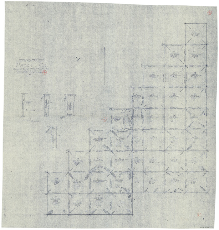
Pecos County Working Sketch 96
Print $20.00
- Digital $50.00
Pecos County Working Sketch 96
1970
Size 41.2 x 39.0 inches
Map/Doc 71569
Tarrant County Sketch File 15

Print $4.00
- Digital $50.00
Tarrant County Sketch File 15
1859
Size 13.2 x 8.1 inches
Map/Doc 37708
Wise County Working Sketch 24

Print $40.00
- Digital $50.00
Wise County Working Sketch 24
1983
Size 37.1 x 58.2 inches
Map/Doc 72638
Map of Comanche County

Print $20.00
- Digital $50.00
Map of Comanche County
1856
Size 22.5 x 29.8 inches
Map/Doc 3432
Wichita County Sketch File 24

Print $20.00
- Digital $50.00
Wichita County Sketch File 24
1919
Size 17.3 x 24.0 inches
Map/Doc 12684
You may also like
Flight Mission No. CRE-1R, Frame 120, Jackson County

Print $20.00
- Digital $50.00
Flight Mission No. CRE-1R, Frame 120, Jackson County
1956
Size 16.1 x 15.9 inches
Map/Doc 85331
Real County Working Sketch 33

Print $40.00
- Digital $50.00
Real County Working Sketch 33
1948
Size 61.0 x 37.7 inches
Map/Doc 71925
Harris County Working Sketch 44

Print $20.00
- Digital $50.00
Harris County Working Sketch 44
1941
Size 24.9 x 38.3 inches
Map/Doc 65936
Current Miscellaneous File 11

Print $50.00
- Digital $50.00
Current Miscellaneous File 11
1930
Size 11.2 x 8.7 inches
Map/Doc 73778
The Chief Justice County of Austin. Proposed, No Date

Print $20.00
The Chief Justice County of Austin. Proposed, No Date
2020
Size 16.7 x 21.7 inches
Map/Doc 96037
Galveston County Rolled Sketch 42

Print $20.00
- Digital $50.00
Galveston County Rolled Sketch 42
1982
Size 42.9 x 40.6 inches
Map/Doc 9021
Map of Texas in 1830 Showing Spanish Colonies

Print $20.00
- Digital $50.00
Map of Texas in 1830 Showing Spanish Colonies
Size 41.1 x 42.0 inches
Map/Doc 73588
Shelby County Rolled Sketch 16

Print $20.00
- Digital $50.00
Shelby County Rolled Sketch 16
1935
Size 33.0 x 43.8 inches
Map/Doc 9925
Cameron County

Print $20.00
- Digital $50.00
Cameron County
1976
Size 32.2 x 39.0 inches
Map/Doc 73098
Bandera County Working Sketch 32

Print $20.00
- Digital $50.00
Bandera County Working Sketch 32
1956
Size 22.7 x 18.4 inches
Map/Doc 67628
Kerr County Working Sketch 28

Print $20.00
- Digital $50.00
Kerr County Working Sketch 28
1971
Size 38.5 x 39.1 inches
Map/Doc 70059
Block M6 in Castro, Swisher, and Randall Co's, Tex.

Print $20.00
- Digital $50.00
Block M6 in Castro, Swisher, and Randall Co's, Tex.
Size 13.8 x 17.2 inches
Map/Doc 90397