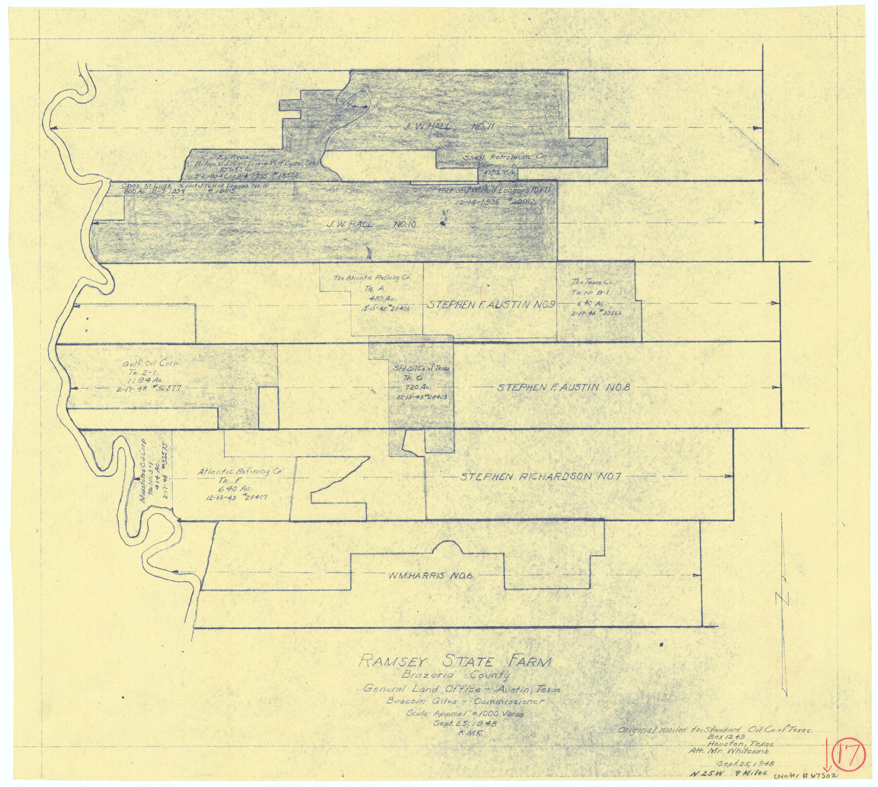
Brazoria County Working Sketch 17
Ramsey State Farm
-
Map/Doc
67502
-
Collection
General Map Collection
-
Object Dates
9/25/1948 (Creation Date)
-
People and Organizations
Bascom Giles (GLO Commissioner)
-
Counties
Brazoria
-
Subjects
Surveying Working Sketch
-
Height x Width
17.0 x 19.0 inches
43.2 x 48.3 cm
-
Scale
1" = 1000 varas
-
Comments
Surveys located about nine miles North 25 degrees West of Angleton, Texas.
Part of: General Map Collection
Menard County Rolled Sketch 14

Print $20.00
- Digital $50.00
Menard County Rolled Sketch 14
Size 39.8 x 34.1 inches
Map/Doc 6760
Nueces County Rolled Sketch 50

Print $20.00
- Digital $50.00
Nueces County Rolled Sketch 50
1939
Size 21.9 x 38.0 inches
Map/Doc 9605
Upton County Sketch File 6

Print $10.00
- Digital $50.00
Upton County Sketch File 6
1909
Size 11.3 x 8.6 inches
Map/Doc 38815
Fort Bend County Sketch File 4

Print $4.00
- Digital $50.00
Fort Bend County Sketch File 4
1876
Size 10.0 x 8.4 inches
Map/Doc 22885
Mills County Boundary File 4a

Print $4.00
- Digital $50.00
Mills County Boundary File 4a
Size 14.2 x 8.6 inches
Map/Doc 57294
Angelina County Working Sketch 21

Print $20.00
- Digital $50.00
Angelina County Working Sketch 21
1947
Size 35.7 x 35.8 inches
Map/Doc 67102
Crosby County Rolled Sketch 2

Print $20.00
- Digital $50.00
Crosby County Rolled Sketch 2
1980
Size 24.7 x 18.7 inches
Map/Doc 5642
Hemphill County Working Sketch 16

Print $20.00
- Digital $50.00
Hemphill County Working Sketch 16
1971
Size 27.0 x 40.0 inches
Map/Doc 66111
Johnson County Working Sketch 29

Print $20.00
- Digital $50.00
Johnson County Working Sketch 29
2006
Size 26.4 x 37.5 inches
Map/Doc 83060
Tyler County Sketch File 23

Print $20.00
- Digital $50.00
Tyler County Sketch File 23
Size 25.3 x 20.9 inches
Map/Doc 12500
Polk County Sketch File 35

Print $8.00
- Digital $50.00
Polk County Sketch File 35
1891
Size 14.2 x 8.7 inches
Map/Doc 34232
Map of Galveston, Harrisburg & San Antonio Railway in Pecos County

Print $40.00
- Digital $50.00
Map of Galveston, Harrisburg & San Antonio Railway in Pecos County
1888
Size 26.0 x 80.9 inches
Map/Doc 64399
You may also like
[State Capitol Leagues along Bailey-Lamb County Line]
![90163, [State Capitol Leagues along Bailey-Lamb County Line], Twichell Survey Records](https://historictexasmaps.com/wmedia_w700/maps/90163-1.tif.jpg)
Print $20.00
- Digital $50.00
[State Capitol Leagues along Bailey-Lamb County Line]
Size 20.7 x 21.3 inches
Map/Doc 90163
Webb County Sketch File 10-1

Print $20.00
- Digital $50.00
Webb County Sketch File 10-1
1850
Size 14.8 x 15.5 inches
Map/Doc 12625
Flight Mission No. DAG-21K, Frame 90, Matagorda County

Print $20.00
- Digital $50.00
Flight Mission No. DAG-21K, Frame 90, Matagorda County
1952
Size 18.5 x 22.2 inches
Map/Doc 86419
North and South Sulphur Rivers, Sulphur Bluff Sheet

Print $20.00
- Digital $50.00
North and South Sulphur Rivers, Sulphur Bluff Sheet
1933
Size 37.6 x 37.2 inches
Map/Doc 65163

Foard County Sketch File 37

Print $4.00
- Digital $50.00
Foard County Sketch File 37
1891
Size 11.2 x 9.1 inches
Map/Doc 22869
Upton County Rolled Sketch 14

Print $20.00
- Digital $50.00
Upton County Rolled Sketch 14
Size 43.2 x 32.0 inches
Map/Doc 10038
Presidio County Rolled Sketch 78

Print $20.00
- Digital $50.00
Presidio County Rolled Sketch 78
1941
Size 32.4 x 39.2 inches
Map/Doc 7364
Montgomery County Texas Historical Map

Montgomery County Texas Historical Map
Size 23.2 x 35.3 inches
Map/Doc 94404
[Capitol Leagues 216-229]
![90705, [Capitol Leagues 216-229], Twichell Survey Records](https://historictexasmaps.com/wmedia_w700/maps/90705-1.tif.jpg)
Print $20.00
- Digital $50.00
[Capitol Leagues 216-229]
Size 25.2 x 26.7 inches
Map/Doc 90705
Terrell County Rolled Sketch 44

Print $20.00
- Digital $50.00
Terrell County Rolled Sketch 44
1952
Size 18.3 x 22.9 inches
Map/Doc 7947
Aransas County Boundary File 5a

Print $14.00
- Digital $50.00
Aransas County Boundary File 5a
Size 11.3 x 8.7 inches
Map/Doc 49796