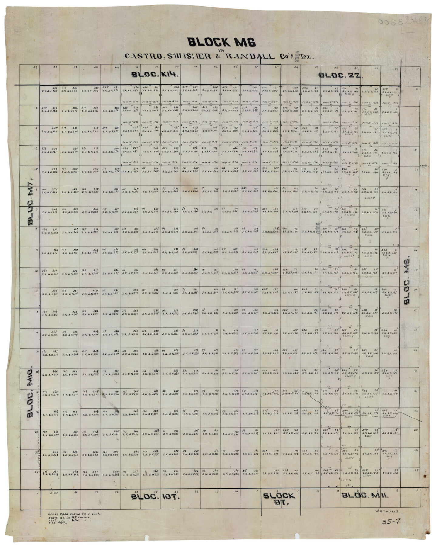
Block M6 in Castro, Swisher, and Randall Co's, Tex.
35-7
-
Map/Doc
90397
-
Collection
Twichell Survey Records
-
Counties
Castro Swisher Randall Deaf Smith
-
Height x Width
13.8 x 17.2 inches
35.1 x 43.7 cm
Part of: Twichell Survey Records
[Leagues along West line of County]
![90547, [Leagues along West line of County], Twichell Survey Records](https://historictexasmaps.com/wmedia_w700/maps/90547-1.tif.jpg)
Print $2.00
- Digital $50.00
[Leagues along West line of County]
Size 5.7 x 11.6 inches
Map/Doc 90547
Sec. 22, Block 103

Print $2.00
- Digital $50.00
Sec. 22, Block 103
Size 8.4 x 9.5 inches
Map/Doc 90431

[Blocks N and B]
![90498, [Blocks N and B], Twichell Survey Records](https://historictexasmaps.com/wmedia_w700/maps/90498-1.tif.jpg)
Print $3.00
- Digital $50.00
[Blocks N and B]
Size 10.0 x 11.4 inches
Map/Doc 90498
[Vicinity of Wilson Strickland Survey]
![91380, [Vicinity of Wilson Strickland Survey], Twichell Survey Records](https://historictexasmaps.com/wmedia_w700/maps/91380-1.tif.jpg)
Print $20.00
- Digital $50.00
[Vicinity of Wilson Strickland Survey]
Size 37.1 x 25.5 inches
Map/Doc 91380
[Sketch of part of G. & M. Block 5, G. & M. Block 4, Block M19 and Block 21W]
![93079, [Sketch of part of G. & M. Block 5, G. & M. Block 4, Block M19 and Block 21W], Twichell Survey Records](https://historictexasmaps.com/wmedia_w700/maps/93079-1.tif.jpg)
Print $20.00
- Digital $50.00
[Sketch of part of G. & M. Block 5, G. & M. Block 4, Block M19 and Block 21W]
Size 22.8 x 15.6 inches
Map/Doc 93079
[McLennan County School Leagues 3 and 4, Elizabeth Finley, Wm. Van Norman, Harvey Kendrick surveys and surveys to the west]
![90929, [McLennan County School Leagues 3 and 4, Elizabeth Finley, Wm. Van Norman, Harvey Kendrick surveys and surveys to the west], Twichell Survey Records](https://historictexasmaps.com/wmedia_w700/maps/90929-1.tif.jpg)
Print $20.00
- Digital $50.00
[McLennan County School Leagues 3 and 4, Elizabeth Finley, Wm. Van Norman, Harvey Kendrick surveys and surveys to the west]
Size 19.5 x 26.7 inches
Map/Doc 90929
[Sketch of Survey 152, Block 9]
![93095, [Sketch of Survey 152, Block 9], Twichell Survey Records](https://historictexasmaps.com/wmedia_w700/maps/93095-1.tif.jpg)
Print $2.00
- Digital $50.00
[Sketch of Survey 152, Block 9]
Size 5.1 x 6.3 inches
Map/Doc 93095
Roberts Addition to the City of Morton

Print $3.00
- Digital $50.00
Roberts Addition to the City of Morton
1958
Size 11.8 x 11.4 inches
Map/Doc 92540
Sketch of the Giles Connell Ranch in Ector and Crane Counties

Print $20.00
- Digital $50.00
Sketch of the Giles Connell Ranch in Ector and Crane Counties
1918
Size 12.8 x 19.6 inches
Map/Doc 90303
[Block 37, Townships 1 and 2 North]
![91344, [Block 37, Townships 1 and 2 North], Twichell Survey Records](https://historictexasmaps.com/wmedia_w700/maps/91344-1.tif.jpg)
Print $20.00
- Digital $50.00
[Block 37, Townships 1 and 2 North]
Size 13.9 x 34.3 inches
Map/Doc 91344
[Leagues 464-467 and vicinity]
![91559, [Leagues 464-467 and vicinity], Twichell Survey Records](https://historictexasmaps.com/wmedia_w700/maps/91559-1.tif.jpg)
Print $20.00
- Digital $50.00
[Leagues 464-467 and vicinity]
Size 18.4 x 12.1 inches
Map/Doc 91559
You may also like
Culberson County Sketch File 3b

Print $20.00
- Digital $50.00
Culberson County Sketch File 3b
1880
Size 20.3 x 28.0 inches
Map/Doc 11262
Flight Mission No. DQO-8K, Frame 143, Galveston County

Print $20.00
- Digital $50.00
Flight Mission No. DQO-8K, Frame 143, Galveston County
1952
Size 18.6 x 22.5 inches
Map/Doc 85205
Travis County Working Sketch 2

Print $20.00
- Digital $50.00
Travis County Working Sketch 2
1906
Size 30.8 x 25.9 inches
Map/Doc 69386
Hudspeth County Sketch File 4a

Print $22.00
- Digital $50.00
Hudspeth County Sketch File 4a
1858
Size 16.4 x 14.3 inches
Map/Doc 26889
Cass County Working Sketch 55

Print $20.00
- Digital $50.00
Cass County Working Sketch 55
2013
Size 17.3 x 20.6 inches
Map/Doc 93415
Travis County Working Sketch 52

Print $20.00
- Digital $50.00
Travis County Working Sketch 52
1985
Size 28.2 x 10.0 inches
Map/Doc 69436
Flight Mission No. DQO-14T, Frame 65, Galveston County

Print $20.00
- Digital $50.00
Flight Mission No. DQO-14T, Frame 65, Galveston County
1958
Size 17.6 x 17.4 inches
Map/Doc 85216
Translations of Titles issued under the Second Contract [500 Families] of Stephen F. Austin with the Government of Coahuila & Texas - Volume 1
![94546, Translations of Titles issued under the Second Contract [500 Families] of Stephen F. Austin with the Government of Coahuila & Texas - Volume 1, Historical Volumes](https://historictexasmaps.com/wmedia_w700/pdf_converted_jpg/qi_pdf_thumbnail_39135.jpg)
Translations of Titles issued under the Second Contract [500 Families] of Stephen F. Austin with the Government of Coahuila & Texas - Volume 1
1840
Map/Doc 94546
Victoria County Sketch File 14

Print $10.00
- Digital $50.00
Victoria County Sketch File 14
2002
Size 11.0 x 8.5 inches
Map/Doc 95398
Collin County Working Sketch 5

Print $20.00
- Digital $50.00
Collin County Working Sketch 5
1992
Size 14.2 x 19.7 inches
Map/Doc 68099
Kimble County Sketch File 17

Print $17.00
- Digital $50.00
Kimble County Sketch File 17
Size 11.5 x 8.5 inches
Map/Doc 28947
Childress County Sketch File 7a

Print $20.00
- Digital $50.00
Childress County Sketch File 7a
Size 14.9 x 17.7 inches
Map/Doc 11080