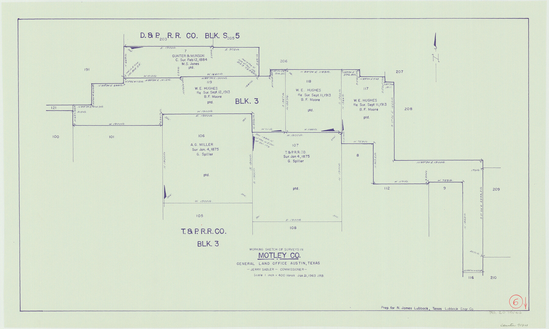
Motley County Working Sketch 6
-
Map/Doc
71211
-
Collection
General Map Collection
-
Object Dates
1/31/1963 (Creation Date)
-
Counties
Motley
-
Subjects
Surveying Working Sketch
-
Height x Width
17.6 x 29.3 inches
44.7 x 74.4 cm
-
Scale
1" = 400 varas
Part of: General Map Collection
Presidio County Rolled Sketch 121

Print $40.00
- Digital $50.00
Presidio County Rolled Sketch 121
1939
Size 50.4 x 43.1 inches
Map/Doc 9797
Hemphill County Working Sketch Graphic Index - sheet 2

Print $20.00
- Digital $50.00
Hemphill County Working Sketch Graphic Index - sheet 2
1899
Size 40.2 x 38.2 inches
Map/Doc 76575
Nolan County Working Sketch 10

Print $40.00
- Digital $50.00
Nolan County Working Sketch 10
1971
Size 78.9 x 37.0 inches
Map/Doc 71301
Freestone County Working Sketch 8

Print $40.00
- Digital $50.00
Freestone County Working Sketch 8
1960
Size 60.6 x 36.6 inches
Map/Doc 69250
Glasscock County Sketch File 6

Print $6.00
- Digital $50.00
Glasscock County Sketch File 6
1929
Size 14.8 x 10.9 inches
Map/Doc 24164
[Sketch for Mineral Application 12206 - Cow Bayou, O. B. Sawyer]
![65568, [Sketch for Mineral Application 12206 - Cow Bayou, O. B. Sawyer], General Map Collection](https://historictexasmaps.com/wmedia_w700/maps/65568.tif.jpg)
Print $40.00
- Digital $50.00
[Sketch for Mineral Application 12206 - Cow Bayou, O. B. Sawyer]
Size 37.4 x 140.2 inches
Map/Doc 65568
Beaumont, Texas

Print $20.00
- Digital $50.00
Beaumont, Texas
1930
Size 10.3 x 32.7 inches
Map/Doc 96428
Flight Mission No. CRC-4R, Frame 172, Chambers County

Print $20.00
- Digital $50.00
Flight Mission No. CRC-4R, Frame 172, Chambers County
1956
Size 18.6 x 22.3 inches
Map/Doc 84923
King County Boundary File 5a

Print $40.00
- Digital $50.00
King County Boundary File 5a
Size 10.3 x 38.1 inches
Map/Doc 64922
United States - Gulf Coast Texas - Northern part of Laguna Madre

Print $20.00
- Digital $50.00
United States - Gulf Coast Texas - Northern part of Laguna Madre
1941
Size 27.2 x 18.4 inches
Map/Doc 72935
Flight Mission No. BRE-2P, Frame 70, Nueces County

Print $20.00
- Digital $50.00
Flight Mission No. BRE-2P, Frame 70, Nueces County
1956
Size 18.5 x 22.6 inches
Map/Doc 86765
[Map of Nacogdoches County]
![10784, [Map of Nacogdoches County], General Map Collection](https://historictexasmaps.com/wmedia_w700/maps/10784-1.tif.jpg)
Print $40.00
- Digital $50.00
[Map of Nacogdoches County]
1840
Size 79.3 x 69.8 inches
Map/Doc 10784
You may also like
Jefferson County Working Sketch 28

Print $20.00
- Digital $50.00
Jefferson County Working Sketch 28
1977
Size 46.2 x 42.9 inches
Map/Doc 66571
Hopkins County Working Sketch 2

Print $20.00
- Digital $50.00
Hopkins County Working Sketch 2
1954
Size 25.3 x 21.2 inches
Map/Doc 66227
Amistad International Reservoir on Rio Grande 91

Print $20.00
- Digital $50.00
Amistad International Reservoir on Rio Grande 91
1950
Size 28.5 x 41.0 inches
Map/Doc 75521

Clay County Sketch File 23

Print $4.00
- Digital $50.00
Clay County Sketch File 23
Size 18.9 x 23.0 inches
Map/Doc 11086
Atascosa County Rolled Sketch 22

Print $40.00
- Digital $50.00
Atascosa County Rolled Sketch 22
1917
Size 26.5 x 57.2 inches
Map/Doc 8922
Victoria County Rolled Sketch 4A

Print $40.00
- Digital $50.00
Victoria County Rolled Sketch 4A
Size 66.4 x 43.9 inches
Map/Doc 10095

Mills County Boundary File 2

Print $6.00
- Digital $50.00
Mills County Boundary File 2
Size 14.1 x 8.7 inches
Map/Doc 57278
Chambers County Sketch File 2

Print $8.00
- Digital $50.00
Chambers County Sketch File 2
Size 13.4 x 10.5 inches
Map/Doc 17518
Map of Limestone County

Print $20.00
- Digital $50.00
Map of Limestone County
1869
Size 22.1 x 22.4 inches
Map/Doc 3818
Flight Mission No. DIX-10P, Frame 83, Aransas County

Print $20.00
- Digital $50.00
Flight Mission No. DIX-10P, Frame 83, Aransas County
1956
Size 18.7 x 22.3 inches
Map/Doc 83944