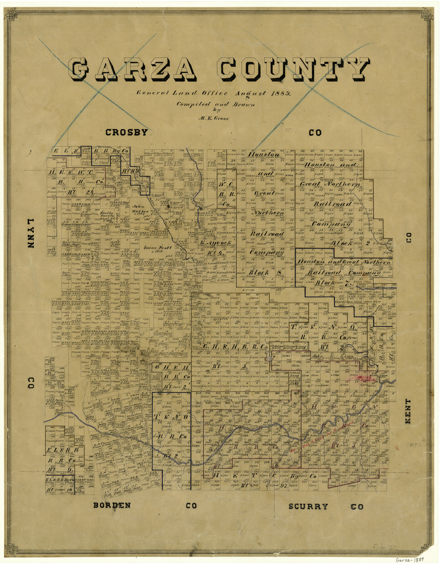
Garza County
-
Map/Doc
3579
-
Collection
General Map Collection
-
Object Dates
8/1889 (Creation Date)
-
People and Organizations
M.E. Groos (Draftsman)
-
Counties
Garza
-
Subjects
County
-
Height x Width
27.3 x 21.3 inches
69.3 x 54.1 cm
-
Features
Yellow House Canyon
Duffy Peak
Gobblers Creek
Double Mountain Fork of Brazos River
Cooper Branch [of Brazos River]
Sand Creek
Salt Fork
Part of: General Map Collection
Henderson County Rolled Sketch 11

Print $20.00
- Digital $50.00
Henderson County Rolled Sketch 11
1915
Size 29.2 x 41.6 inches
Map/Doc 76147
Throckmorton County Working Sketch 2

Print $20.00
- Digital $50.00
Throckmorton County Working Sketch 2
1919
Size 20.9 x 16.9 inches
Map/Doc 62111
Flight Mission No. DCL-7C, Frame 11, Kenedy County

Print $20.00
- Digital $50.00
Flight Mission No. DCL-7C, Frame 11, Kenedy County
1943
Size 15.4 x 15.2 inches
Map/Doc 86003
[Sketch for Mineral Application 27670 - Strip between Simon Sanchez leagues and Trinity River]
![2866, [Sketch for Mineral Application 27670 - Strip between Simon Sanchez leagues and Trinity River], General Map Collection](https://historictexasmaps.com/wmedia_w700/maps/2866-1.tif.jpg)
Print $20.00
- Digital $50.00
[Sketch for Mineral Application 27670 - Strip between Simon Sanchez leagues and Trinity River]
1934
Size 17.3 x 36.7 inches
Map/Doc 2866
Tyler County Working Sketch 5

Print $20.00
- Digital $50.00
Tyler County Working Sketch 5
1928
Size 19.4 x 21.2 inches
Map/Doc 69475
Brazoria County Working Sketch 41

Print $20.00
- Digital $50.00
Brazoria County Working Sketch 41
1982
Size 26.5 x 35.7 inches
Map/Doc 67526
Milam County Sketch File 6

Print $4.00
- Digital $50.00
Milam County Sketch File 6
1902
Size 14.2 x 8.6 inches
Map/Doc 31634
Foard County Sketch File 20

Print $4.00
- Digital $50.00
Foard County Sketch File 20
1885
Size 14.3 x 9.0 inches
Map/Doc 22837

Flight Mission No. DQN-2K, Frame 163, Calhoun County

Print $20.00
- Digital $50.00
Flight Mission No. DQN-2K, Frame 163, Calhoun County
1953
Size 18.5 x 22.2 inches
Map/Doc 84325
Childress County Sketch File 7a

Print $20.00
- Digital $50.00
Childress County Sketch File 7a
Size 14.9 x 17.7 inches
Map/Doc 11080
Railroad Track Map, H&TCRRCo., Falls County, Texas

Print $4.00
- Digital $50.00
Railroad Track Map, H&TCRRCo., Falls County, Texas
1918
Size 11.5 x 18.6 inches
Map/Doc 62850
You may also like
[Bastrop District]
![3131, [Bastrop District], General Map Collection](https://historictexasmaps.com/wmedia_w700/maps/3131.tif.jpg)
Print $40.00
- Digital $50.00
[Bastrop District]
1895
Size 36.5 x 52.0 inches
Map/Doc 3131
[Various County School Lands]
![89928, [Various County School Lands], Twichell Survey Records](https://historictexasmaps.com/wmedia_w700/maps/89928-1.tif.jpg)
Print $40.00
- Digital $50.00
[Various County School Lands]
Size 57.6 x 42.9 inches
Map/Doc 89928
Hansford County Working Sketch 9

Print $20.00
- Digital $50.00
Hansford County Working Sketch 9
1984
Size 31.5 x 38.2 inches
Map/Doc 63381
Uvalde County Sketch File 3

Print $4.00
- Digital $50.00
Uvalde County Sketch File 3
1880
Size 9.1 x 15.0 inches
Map/Doc 38949
Randall County Boundary File 2

Print $14.00
- Digital $50.00
Randall County Boundary File 2
Size 8.9 x 7.9 inches
Map/Doc 58111
Galveston Bay and Approaches

Print $20.00
- Digital $50.00
Galveston Bay and Approaches
1924
Size 45.5 x 34.0 inches
Map/Doc 69873

Reeves County

Print $40.00
- Digital $50.00
Reeves County
1945
Size 48.3 x 39.8 inches
Map/Doc 73273
Starr County Sketch File D

Print $8.00
- Digital $50.00
Starr County Sketch File D
1892
Size 14.2 x 8.7 inches
Map/Doc 36915
Brooks County Working Sketch 4

Print $20.00
- Digital $50.00
Brooks County Working Sketch 4
1906
Size 28.6 x 24.9 inches
Map/Doc 67788
Edwards County Sketch File 12b

Print $4.00
- Digital $50.00
Edwards County Sketch File 12b
Size 14.4 x 8.8 inches
Map/Doc 21698
Township No. 2 South Range No. 20 West of the Indian Meridian

Print $20.00
- Digital $50.00
Township No. 2 South Range No. 20 West of the Indian Meridian
1875
Size 19.2 x 24.5 inches
Map/Doc 75180