Edwards County Sketch File 12b
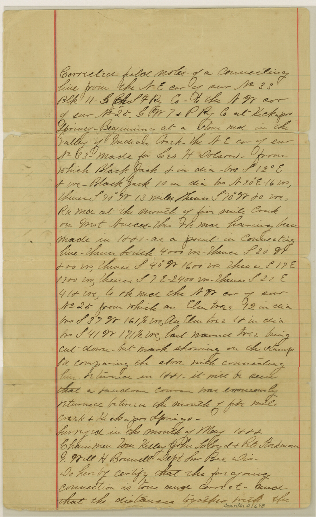
[Connecting line from northeast corner of survey 33, Block H, G. C. & S. F. RR. Co. to the northwest corner of survey 25, G. W. T. & P. RR. Co. at Kickapoo Springs on West Nueces]
-
Map/Doc
21698
-
Collection
General Map Collection
-
Object Dates
1888/8/10 (File Date)
-
People and Organizations
Will H. Bonnell (Surveyor/Engineer)
-
Counties
Edwards
-
Subjects
Surveying Sketch File
-
Height x Width
14.4 x 8.8 inches
36.6 x 22.4 cm
-
Medium
paper, manuscript
-
Features
Kickapoo Spring
Indian Creek
Five Mile Creek
West [prong] of Nueces River
Part of: General Map Collection
Flight Mission No. CRC-2R, Frame 121, Chambers County

Print $20.00
- Digital $50.00
Flight Mission No. CRC-2R, Frame 121, Chambers County
1956
Size 18.7 x 22.4 inches
Map/Doc 84745
Kaufman County Sketch File 19

Print $30.00
- Digital $50.00
Kaufman County Sketch File 19
1922
Size 11.2 x 8.7 inches
Map/Doc 28666
Hardin County Sketch File 52

Print $6.00
- Digital $50.00
Hardin County Sketch File 52
Size 11.5 x 8.9 inches
Map/Doc 25210
Donley County

Print $20.00
- Digital $50.00
Donley County
1944
Size 46.8 x 40.6 inches
Map/Doc 95484
Roberts County Boundary File 1

Print $40.00
- Digital $50.00
Roberts County Boundary File 1
Size 14.4 x 8.9 inches
Map/Doc 58313
Van Zandt County Working Sketch 16

Print $20.00
- Digital $50.00
Van Zandt County Working Sketch 16
1991
Size 40.5 x 34.0 inches
Map/Doc 72266
Lipscomb County Boundary File 15

Print $44.00
- Digital $50.00
Lipscomb County Boundary File 15
Size 11.3 x 8.7 inches
Map/Doc 56382
Brooks County Boundary File Index

Print $2.00
- Digital $50.00
Brooks County Boundary File Index
Size 8.6 x 3.1 inches
Map/Doc 50808
Montgomery County Working Sketch 24

Print $40.00
- Digital $50.00
Montgomery County Working Sketch 24
1941
Size 35.8 x 52.5 inches
Map/Doc 71131
Kleberg County Rolled Sketch 10-5

Print $20.00
- Digital $50.00
Kleberg County Rolled Sketch 10-5
1951
Size 37.6 x 35.6 inches
Map/Doc 9394
Morris County Rolled Sketch 2A

Print $20.00
- Digital $50.00
Morris County Rolled Sketch 2A
Size 24.4 x 19.3 inches
Map/Doc 10266
Hays County Sketch File 32

Print $8.00
- Digital $50.00
Hays County Sketch File 32
Size 14.3 x 8.8 inches
Map/Doc 26264
You may also like
Potter County Sketch File 16

Print $38.00
- Digital $50.00
Potter County Sketch File 16
Size 13.0 x 13.9 inches
Map/Doc 34401
Flight Mission No. CRC-3R, Frame 201, Chambers County

Print $20.00
- Digital $50.00
Flight Mission No. CRC-3R, Frame 201, Chambers County
1956
Size 18.6 x 22.4 inches
Map/Doc 84856
General Chart of the Kingdom of New Spain betn. parallels of 16 & 38° N. from materials in Mexico at commencement of year of 1804

Print $20.00
General Chart of the Kingdom of New Spain betn. parallels of 16 & 38° N. from materials in Mexico at commencement of year of 1804
1804
Size 38.4 x 26.5 inches
Map/Doc 95310
Hidalgo County

Print $20.00
- Digital $50.00
Hidalgo County
1911
Size 42.1 x 28.7 inches
Map/Doc 16850
Flight Mission No. DAH-9M, Frame 154, Orange County

Print $20.00
- Digital $50.00
Flight Mission No. DAH-9M, Frame 154, Orange County
1953
Size 18.3 x 22.3 inches
Map/Doc 86853
[Galveston, Harrisburg & San Antonio from El Paso-Presidio county boundary to Presidio-Pecos county boundary]
![64718, [Galveston, Harrisburg & San Antonio from El Paso-Presidio county boundary to Presidio-Pecos county boundary], General Map Collection](https://historictexasmaps.com/wmedia_w700/maps/64718.tif.jpg)
Print $40.00
- Digital $50.00
[Galveston, Harrisburg & San Antonio from El Paso-Presidio county boundary to Presidio-Pecos county boundary]
Size 106.1 x 44.3 inches
Map/Doc 64718
Sketch of Part of Crockett County, Texas

Print $20.00
- Digital $50.00
Sketch of Part of Crockett County, Texas
1925
Size 20.0 x 18.0 inches
Map/Doc 92545
Brewster Co[unty]
![16947, Brewster Co[unty], General Map Collection](https://historictexasmaps.com/wmedia_w700/maps/16947.tif.jpg)
Print $40.00
- Digital $50.00
Brewster Co[unty]
1904
Size 63.5 x 48.0 inches
Map/Doc 16947
La Florida / Peruviae Avriferæ Regionis Typus / Guastecan

Print $20.00
- Digital $50.00
La Florida / Peruviae Avriferæ Regionis Typus / Guastecan
1584
Size 16.8 x 20.9 inches
Map/Doc 94100
Brazoria County NRC Article 33.136 Sketch 4

Print $22.00
- Digital $50.00
Brazoria County NRC Article 33.136 Sketch 4
2003
Size 24.3 x 35.8 inches
Map/Doc 80120
[Parts of Blocks M-20, 22 and S]
![91825, [Parts of Blocks M-20, 22 and S], Twichell Survey Records](https://historictexasmaps.com/wmedia_w700/maps/91825-1.tif.jpg)
Print $20.00
- Digital $50.00
[Parts of Blocks M-20, 22 and S]
1921
Size 23.3 x 18.3 inches
Map/Doc 91825
General Highway Map, Fayette County, Texas

Print $20.00
General Highway Map, Fayette County, Texas
1961
Size 18.2 x 24.5 inches
Map/Doc 79465