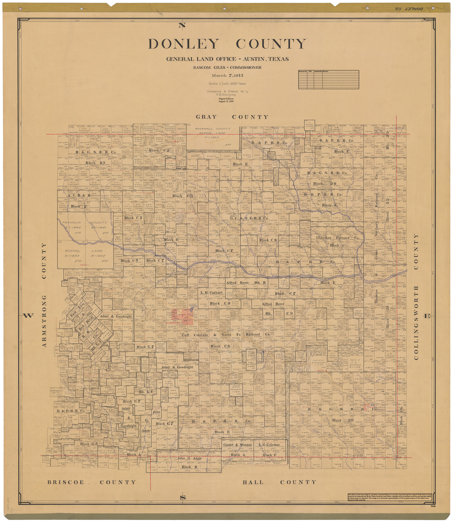
Donley County
General Land Office Official County Map
-
Map/Doc
95484
-
Collection
General Map Collection
-
Object Dates
2019/8/31 (Revision Date)
1944/3/7 (Creation Date)
-
People and Organizations
Cheyenne Betancourt (Draftsman)
Victor E. Sterzing (Draftsman)
Victor E. Sterzing (Compiler)
Bascom Giles (GLO Commissioner)
-
Counties
Donley
-
Subjects
County OCM
-
Height x Width
46.8 x 40.6 inches
118.9 x 103.1 cm
-
Medium
digital image
-
Scale
1" = 2000 varas
Part of: General Map Collection
PSL Field Notes for Blocks C1, C2, and C3 in Pecos and Reeves Counties

PSL Field Notes for Blocks C1, C2, and C3 in Pecos and Reeves Counties
Map/Doc 81669

Flight Mission No. BRA-16M, Frame 90, Jefferson County

Print $20.00
- Digital $50.00
Flight Mission No. BRA-16M, Frame 90, Jefferson County
1953
Size 18.5 x 22.2 inches
Map/Doc 85702
Webb County Rolled Sketch 25

Print $20.00
- Digital $50.00
Webb County Rolled Sketch 25
Size 28.4 x 42.4 inches
Map/Doc 8185
Van Zandt County Sketch File 5

Print $22.00
- Digital $50.00
Van Zandt County Sketch File 5
Size 20.5 x 6.3 inches
Map/Doc 39371
La Salle County Sketch File 39

Print $6.00
- Digital $50.00
La Salle County Sketch File 39
1912
Size 16.4 x 11.4 inches
Map/Doc 29592
Real County Working Sketch 21

Print $20.00
- Digital $50.00
Real County Working Sketch 21
1944
Size 24.8 x 35.7 inches
Map/Doc 71913
Newton County Working Sketch 18

Print $20.00
- Digital $50.00
Newton County Working Sketch 18
1950
Size 14.3 x 13.6 inches
Map/Doc 71264
Taylor County Sketch File 15

Print $12.00
- Digital $50.00
Taylor County Sketch File 15
1881
Size 10.1 x 8.1 inches
Map/Doc 37805
Harris County Working Sketch 81

Print $20.00
- Digital $50.00
Harris County Working Sketch 81
1969
Size 23.6 x 30.0 inches
Map/Doc 65973
Brewster County Working Sketch 53

Print $20.00
- Digital $50.00
Brewster County Working Sketch 53
1951
Size 32.1 x 16.5 inches
Map/Doc 67587
Menard County Working Sketch 17

Print $40.00
- Digital $50.00
Menard County Working Sketch 17
1946
Size 59.0 x 42.9 inches
Map/Doc 70964
You may also like
[Sketch of Blocks Z and 194, showing tie lines with Runnels County School Land survey]
![91665, [Sketch of Blocks Z and 194, showing tie lines with Runnels County School Land survey], Twichell Survey Records](https://historictexasmaps.com/wmedia_w700/maps/91665-1.tif.jpg)
Print $20.00
- Digital $50.00
[Sketch of Blocks Z and 194, showing tie lines with Runnels County School Land survey]
Size 21.5 x 15.5 inches
Map/Doc 91665
[The S.K. Ry. of Texas, State Line to Pecos, Reeves Co., Texas]
![64158, [The S.K. Ry. of Texas, State Line to Pecos, Reeves Co., Texas], General Map Collection](https://historictexasmaps.com/wmedia_w700/maps/64158.tif.jpg)
Print $40.00
- Digital $50.00
[The S.K. Ry. of Texas, State Line to Pecos, Reeves Co., Texas]
1910
Size 18.9 x 120.1 inches
Map/Doc 64158
San Jacinto County Working Sketch 35

Print $20.00
- Digital $50.00
San Jacinto County Working Sketch 35
1955
Size 31.3 x 32.1 inches
Map/Doc 63748
George M. Boles' Ranch Lands

Print $20.00
- Digital $50.00
George M. Boles' Ranch Lands
1935
Size 31.0 x 24.9 inches
Map/Doc 92862
Map of Aransas Co.

Print $20.00
- Digital $50.00
Map of Aransas Co.
1896
Size 38.8 x 36.8 inches
Map/Doc 4874
Flight Mission No. DQO-8K, Frame 21, Galveston County

Print $20.00
- Digital $50.00
Flight Mission No. DQO-8K, Frame 21, Galveston County
1952
Size 18.6 x 22.3 inches
Map/Doc 85144
Kerr County Boundary File 4b

Print $14.00
- Digital $50.00
Kerr County Boundary File 4b
Size 14.3 x 8.8 inches
Map/Doc 64809
Map of Wise County Texas

Print $20.00
- Digital $50.00
Map of Wise County Texas
1912
Size 31.3 x 28.8 inches
Map/Doc 4644
La Salle County Sketch File 47

Print $8.00
- Digital $50.00
La Salle County Sketch File 47
1941
Size 14.2 x 8.9 inches
Map/Doc 29613
[Rusk, Sutton, Garza, and Atascosa County School Lands]
![91219, [Rusk, Sutton, Garza, and Atascosa County School Lands], Twichell Survey Records](https://historictexasmaps.com/wmedia_w700/maps/91219-1.tif.jpg)
Print $20.00
- Digital $50.00
[Rusk, Sutton, Garza, and Atascosa County School Lands]
1913
Size 18.8 x 14.5 inches
Map/Doc 91219
Kerr County Working Sketch 2

Print $20.00
- Digital $50.00
Kerr County Working Sketch 2
1926
Size 18.6 x 17.9 inches
Map/Doc 70033
Washington County Sketch File 3

Print $4.00
- Digital $50.00
Washington County Sketch File 3
1860
Size 8.1 x 9.2 inches
Map/Doc 39648