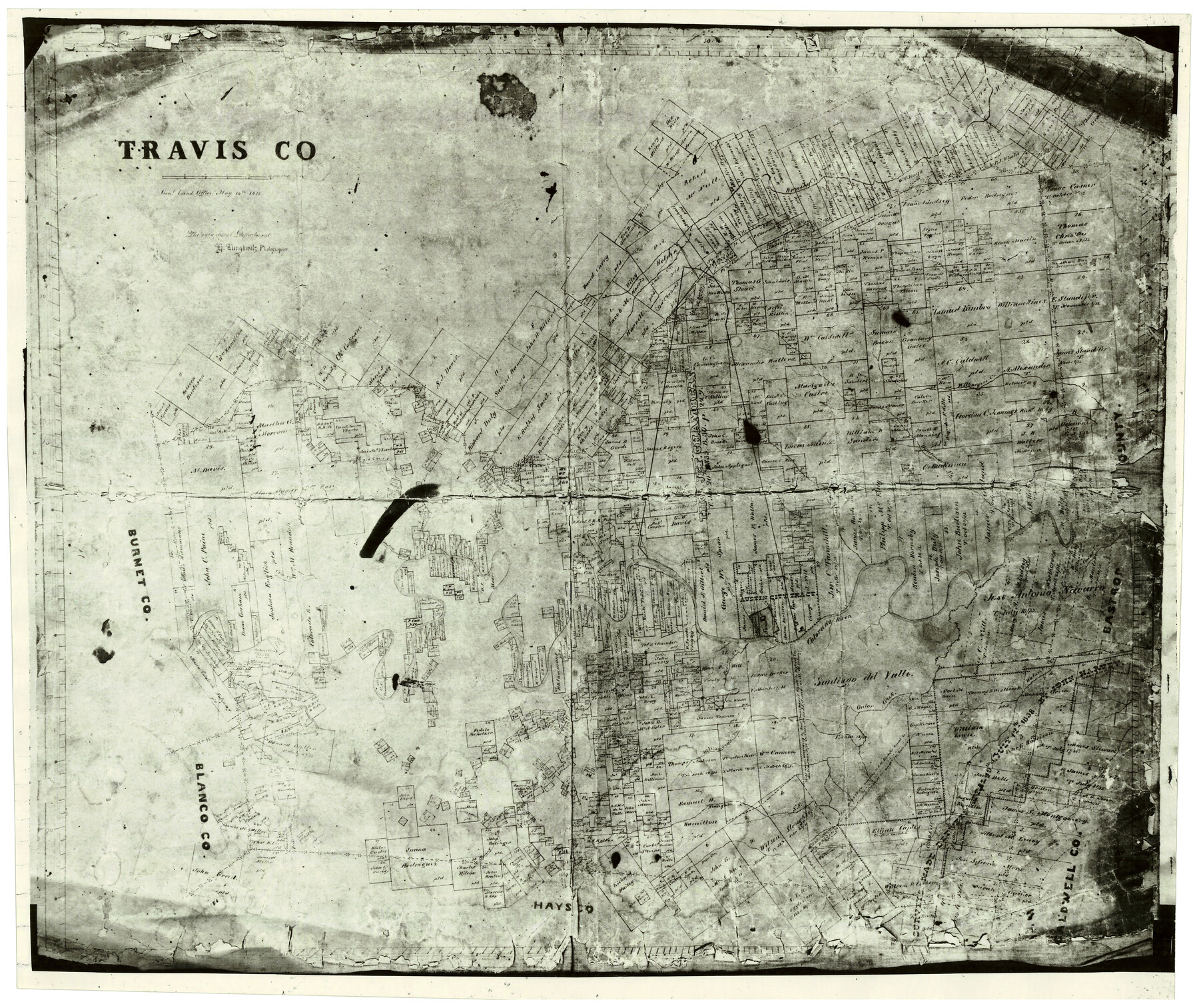
Travis County
- 
                          Map/Doc
4632
 - 
                            Collection
General Map Collection
 - 
                            Object Dates
5/14/1870 (Creation Date)
 - 
                            People and Organizations
Herman Lungkwitz (Draftsman)
 - 
                            Counties
Travis
 - 
                            Subjects
County
 - 
                            Height x Width
17.6 x 20.9 inches
44.7 x 53.1 cm
 - 
                            Features
Shoal Creek
Bear Creek
Waller Creek
Slaughter Creek
Pedernales River
Walnut Creek
Onion Creek
Williamson's Creek
Spring Creek
Cow Creek
Brushy Creek
Colorado River
Austin
Cedar Creek
Gilleland's Creek
Cypress Creek
Cross Creek
Wilbarger's Creek
Lake Creek
 
Part of: General Map Collection
            Kerr County Rolled Sketch 14


                                            Print $20.00                    
                                             -                         Digital $50.00                                    
                Kerr County Rolled Sketch 14
1951
Size 38.3 x 30.6 inches
                                Map/Doc 9345
            
            Tom Green County


                                            Print $40.00                    
                                             -                         Digital $50.00                                    
                Tom Green County
Size 43.6 x 111.2 inches
                                Map/Doc 82058
            
            Palo Pinto County Sketch File 6a


                                            Print $20.00                    
                                             -                         Digital $50.00                                    
                Palo Pinto County Sketch File 6a
Size 37.8 x 38.6 inches
                                Map/Doc 10565
            
            Pecos County Sketch File 13


                                            Print $20.00                    
                                             -                         Digital $50.00                                    
                Pecos County Sketch File 13
Size 22.7 x 18.8 inches
                                Map/Doc 12156
            
            Flight Mission No. CGI-2N, Frame 183, Cameron County


                                            Print $20.00                    
                                             -                         Digital $50.00                                    
                Flight Mission No. CGI-2N, Frame 183, Cameron County
1954
Size 18.7 x 22.2 inches
                                Map/Doc 84543
            
            Boundary between Republic of Texas and US from Logan's Ferry to Red River - surveyed in 1841


                                            Print $20.00                    
                                             -                         Digital $50.00                                    
                Boundary between Republic of Texas and US from Logan's Ferry to Red River - surveyed in 1841
1841
Size 19.4 x 27.4 inches
                                Map/Doc 65415
            
            Roberts County


                                            Print $20.00                    
                                             -                         Digital $50.00                                    
                Roberts County
1932
Size 41.9 x 38.0 inches
                                Map/Doc 73275
            
            Erath County Working Sketch 1


                                            Print $20.00                    
                                             -                         Digital $50.00                                    
                Erath County Working Sketch 1
Size 16.7 x 20.7 inches
                                Map/Doc 69082
            
            El Paso County Working Sketch 32


                                            Print $20.00                    
                                             -                         Digital $50.00                                    
                El Paso County Working Sketch 32
1971
Size 40.2 x 38.3 inches
                                Map/Doc 69054
            
            San Jacinto Co.


                                            Print $20.00                    
                                             -                         Digital $50.00                                    
                San Jacinto Co.
1889
Size 46.4 x 37.9 inches
                                Map/Doc 63016
            
            Jasper County


                                            Print $40.00                    
                                             -                         Digital $50.00                                    
                Jasper County
1946
Size 49.8 x 43.9 inches
                                Map/Doc 95542
            
            Wise County Sketch File 3


                                            Print $4.00                    
                                             -                         Digital $50.00                                    
                Wise County Sketch File 3
1856
Size 10.2 x 8.0 inches
                                Map/Doc 40528
            You may also like
            Garza County Sketch File 11


                                            Print $4.00                    
                                             -                         Digital $50.00                                    
                Garza County Sketch File 11
1901
Size 11.3 x 8.8 inches
                                Map/Doc 24066
            
            Young Territory


                                            Print $20.00                    
                                             -                         Digital $50.00                                    
                Young Territory
1874
Size 29.4 x 29.2 inches
                                Map/Doc 1977
            
            Right of Way and Track Map, The Missouri, Kansas and Texas Ry. of Texas operated by the Missouri, Kansas and Texas Ry. of Texas, Henrietta Division


                                            Print $40.00                    
                                             -                         Digital $50.00                                    
                Right of Way and Track Map, The Missouri, Kansas and Texas Ry. of Texas operated by the Missouri, Kansas and Texas Ry. of Texas, Henrietta Division
1918
Size 25.4 x 56.5 inches
                                Map/Doc 64066
            
            [Heirs of Jno. Breeding and surrounding surveys]


                                            Print $3.00                    
                                             -                         Digital $50.00                                    
                [Heirs of Jno. Breeding and surrounding surveys]
Size 10.5 x 16.1 inches
                                Map/Doc 90494
            
            Cass County Rolled Sketch OPD


                                            Print $20.00                    
                                             -                         Digital $50.00                                    
                Cass County Rolled Sketch OPD
1936
Size 29.6 x 26.1 inches
                                Map/Doc 5484
            
            Palo Pinto County Rolled Sketch 5


                                            Print $40.00                    
                                             -                         Digital $50.00                                    
                Palo Pinto County Rolled Sketch 5
Size 54.4 x 36.0 inches
                                Map/Doc 76021
            
            Montague County


                                            Print $20.00                    
                                             -                         Digital $50.00                                    
                Montague County
1924
Size 46.9 x 33.7 inches
                                Map/Doc 73243
            
            Wise County Sketch File 25


                                            Print $4.00                    
                                             -                         Digital $50.00                                    
                Wise County Sketch File 25
1860
Size 12.5 x 8.1 inches
                                Map/Doc 40572
            
            Lavaca County Working Sketch 22


                                            Print $20.00                    
                                             -                         Digital $50.00                                    
                Lavaca County Working Sketch 22
1983
Size 39.6 x 36.4 inches
                                Map/Doc 70375
            
            Outline Map showing a new route from Texas to Fort Yuma, California for cattle droves and trains en route to California


                                            Print $40.00                    
                                             -                         Digital $50.00                                    
                Outline Map showing a new route from Texas to Fort Yuma, California for cattle droves and trains en route to California
1870
Size 17.3 x 52.7 inches
                                Map/Doc 94048
            
            Kerr County Working Sketch 7


                                            Print $20.00                    
                                             -                         Digital $50.00                                    
                Kerr County Working Sketch 7
1947
Size 38.9 x 30.8 inches
                                Map/Doc 70038
            
            Stephens County Sketch File 13


                                            Print $4.00                    
                                             -                         Digital $50.00                                    
                Stephens County Sketch File 13
Size 11.2 x 8.8 inches
                                Map/Doc 37063