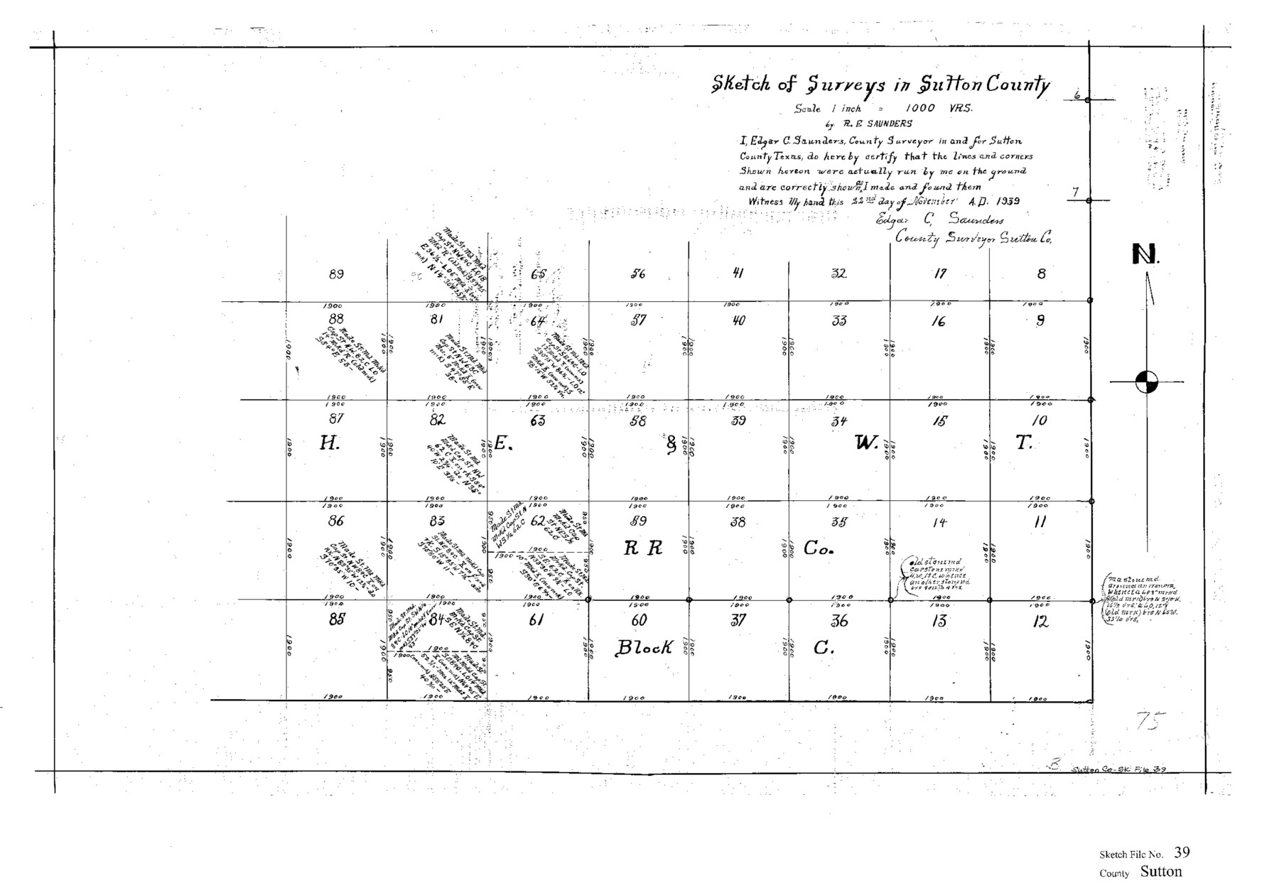
Sutton County Sketch File 39
Sketch of Surveys in Sutton County, Texas
-
Map/Doc
12389
-
Collection
General Map Collection
-
Object Dates
1939/11/22 (Creation Date)
1939/12/6 (File Date)
-
People and Organizations
Edgar C. Saunders (Surveyor/Engineer)
-
Counties
Sutton
-
Subjects
Surveying Sketch File
-
Height x Width
16.8 x 24.2 inches
42.7 x 61.5 cm
-
Medium
paper, photocopy
Part of: General Map Collection
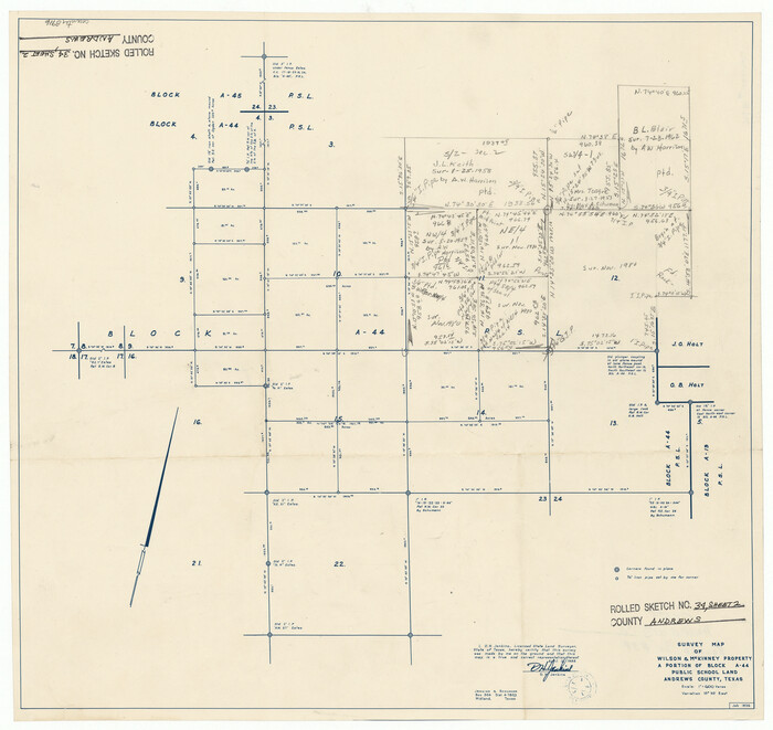
Andrews County Rolled Sketch 34
Print $20.00
- Digital $50.00
Andrews County Rolled Sketch 34
1955
Size 16.4 x 17.3 inches
Map/Doc 8916
Culberson County Working Sketch 71

Print $40.00
- Digital $50.00
Culberson County Working Sketch 71
1975
Size 48.4 x 32.9 inches
Map/Doc 68525
Amistad International Reservoir on Rio Grande 108

Print $20.00
- Digital $50.00
Amistad International Reservoir on Rio Grande 108
1950
Size 28.5 x 40.9 inches
Map/Doc 75539
Duval County Sketch File 53

Print $4.00
- Digital $50.00
Duval County Sketch File 53
1937
Size 11.6 x 7.3 inches
Map/Doc 21416
Ochiltree County Sketch File 3

Print $40.00
- Digital $50.00
Ochiltree County Sketch File 3
1908
Size 15.4 x 12.9 inches
Map/Doc 33177
Flight Mission No. DQN-2K, Frame 145, Calhoun County

Print $20.00
- Digital $50.00
Flight Mission No. DQN-2K, Frame 145, Calhoun County
1953
Size 18.9 x 22.7 inches
Map/Doc 84314

Flight Mission No. CUG-1P, Frame 106, Kleberg County

Print $20.00
- Digital $50.00
Flight Mission No. CUG-1P, Frame 106, Kleberg County
1956
Size 18.8 x 22.3 inches
Map/Doc 86156
Flight Mission No. DCL-7C, Frame 110, Kenedy County

Print $20.00
- Digital $50.00
Flight Mission No. DCL-7C, Frame 110, Kenedy County
1943
Size 18.5 x 22.3 inches
Map/Doc 86075
Sterling County Rolled Sketch 32

Print $20.00
- Digital $50.00
Sterling County Rolled Sketch 32
Size 17.9 x 29.4 inches
Map/Doc 7856
Bosque County Sketch File 17

Print $8.00
- Digital $50.00
Bosque County Sketch File 17
1863
Size 13.0 x 7.9 inches
Map/Doc 14788
Reeves County Working Sketch 36

Print $20.00
- Digital $50.00
Reeves County Working Sketch 36
1970
Size 43.1 x 35.0 inches
Map/Doc 63479
You may also like
Flight Mission No. CUG-1P, Frame 51, Kleberg County

Print $20.00
- Digital $50.00
Flight Mission No. CUG-1P, Frame 51, Kleberg County
1956
Size 18.7 x 22.3 inches
Map/Doc 86129
Jefferson County Sketch File 8

Print $8.00
- Digital $50.00
Jefferson County Sketch File 8
Size 8.0 x 7.6 inches
Map/Doc 28116
General Highway Map, Dickens County, Texas

Print $20.00
General Highway Map, Dickens County, Texas
1961
Size 18.2 x 24.9 inches
Map/Doc 79443
Map from Corpus Christi to Matagorda Bays, Texas [Inset: Survey of the channel of Copono Bay]
![72973, Map from Corpus Christi to Matagorda Bays, Texas [Inset: Survey of the channel of Copono Bay], General Map Collection](https://historictexasmaps.com/wmedia_w700/maps/72973.tif.jpg)
Print $20.00
- Digital $50.00
Map from Corpus Christi to Matagorda Bays, Texas [Inset: Survey of the channel of Copono Bay]
1846
Size 18.2 x 27.5 inches
Map/Doc 72973

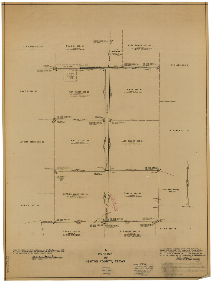
Newton County Rolled Sketch 27A
Print $20.00
- Digital $50.00
Newton County Rolled Sketch 27A
1961
Size 35.9 x 27.1 inches
Map/Doc 6857
Collin County Working Sketch 4

Print $20.00
- Digital $50.00
Collin County Working Sketch 4
1953
Size 20.4 x 21.8 inches
Map/Doc 68098
PSL Field Notes for Blocks 1, 5, 6, and 7 in El Paso County and Blocks 2, 3, 4, 8, 9, 10, 11, 12, 13, and 14 in Hudspeth County

PSL Field Notes for Blocks 1, 5, 6, and 7 in El Paso County and Blocks 2, 3, 4, 8, 9, 10, 11, 12, 13, and 14 in Hudspeth County
Map/Doc 81653
Webb County Rolled Sketch 77

Print $20.00
- Digital $50.00
Webb County Rolled Sketch 77
1980
Size 39.1 x 38.5 inches
Map/Doc 10134
Houston County Working Sketch Graphic Index

Print $40.00
- Digital $50.00
Houston County Working Sketch Graphic Index
1944
Size 48.1 x 42.7 inches
Map/Doc 76582
Brazoria County Working Sketch 14

Print $20.00
- Digital $50.00
Brazoria County Working Sketch 14
1940
Size 33.6 x 43.9 inches
Map/Doc 67499
Wichita County Working Sketch 24

Print $20.00
- Digital $50.00
Wichita County Working Sketch 24
1971
Size 21.2 x 16.2 inches
Map/Doc 72534