Travis County Rolled Sketch 3

Print $40.00
- Digital $50.00
Travis County Rolled Sketch 3
1902
Size: 37.2 x 48.0 inches
10009
Travis County Rolled Sketch 15

Print $20.00
- Digital $50.00
Travis County Rolled Sketch 15
1939
Size: 25.4 x 37.6 inches
10011
Travis County Rolled Sketch 19

Print $20.00
- Digital $50.00
Travis County Rolled Sketch 19
1940
Size: 34.4 x 37.8 inches
10012
Travis County Rolled Sketch 32A

Print $40.00
- Digital $50.00
Travis County Rolled Sketch 32A
Size: 57.6 x 37.3 inches
10013
Travis County Rolled Sketch 37

Print $20.00
- Digital $50.00
Travis County Rolled Sketch 37
1942
Size: 36.1 x 35.6 inches
10014
Travis County Rolled Sketch 47

Print $40.00
- Digital $50.00
Travis County Rolled Sketch 47
1925
Size: 24.9 x 56.8 inches
10016
Travis County Rolled Sketch 49

Print $20.00
- Digital $50.00
Travis County Rolled Sketch 49
Size: 43.0 x 39.9 inches
10017
Travis County Rolled Sketch 55

Print $40.00
- Digital $50.00
Travis County Rolled Sketch 55
Size: 43.1 x 50.5 inches
10020
Travis County Rolled Sketch 44

Print $20.00
- Digital $50.00
Travis County Rolled Sketch 44
Size: 34.2 x 35.6 inches
10052
Travis County Rolled Sketch 32B

Print $20.00
- Digital $50.00
Travis County Rolled Sketch 32B
1948
Size: 37.5 x 43.4 inches
10310
Travis County Rolled Sketch 47

Print $40.00
- Digital $50.00
Travis County Rolled Sketch 47
1923
Size: 57.3 x 26.5 inches
10626
Travis County Rolled Sketch 47

Print $40.00
- Digital $50.00
Travis County Rolled Sketch 47
1928
Size: 57.3 x 26.1 inches
10627
Travis County Rolled Sketch 47

Print $40.00
- Digital $50.00
Travis County Rolled Sketch 47
1931
Size: 57.2 x 25.4 inches
10628
Travis County Rolled Sketch 37

Print $20.00
- Digital $50.00
Travis County Rolled Sketch 37
1942
Size: 33.6 x 32.7 inches
10737
Map of the C.C. Browning survey 412 enlarged from General Land Office map of the west part of Travis County, Texas

Print $3.00
- Digital $50.00
Map of the C.C. Browning survey 412 enlarged from General Land Office map of the west part of Travis County, Texas
1920
Size: 11.3 x 9.1 inches
10752
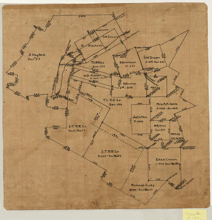
[Surveying sketch of S. Hayford, E. T. R.R. Co., T. C. R. R. Co., et al in Travis County, Texas]
Print $20.00
- Digital $50.00
[Surveying sketch of S. Hayford, E. T. R.R. Co., T. C. R. R. Co., et al in Travis County, Texas]
Size: 18.0 x 17.3 inches
10753
Map of the Western Part of Travis County, Texas

Print $20.00
- Digital $50.00
Map of the Western Part of Travis County, Texas
1919
Size: 36.2 x 29.9 inches
10754
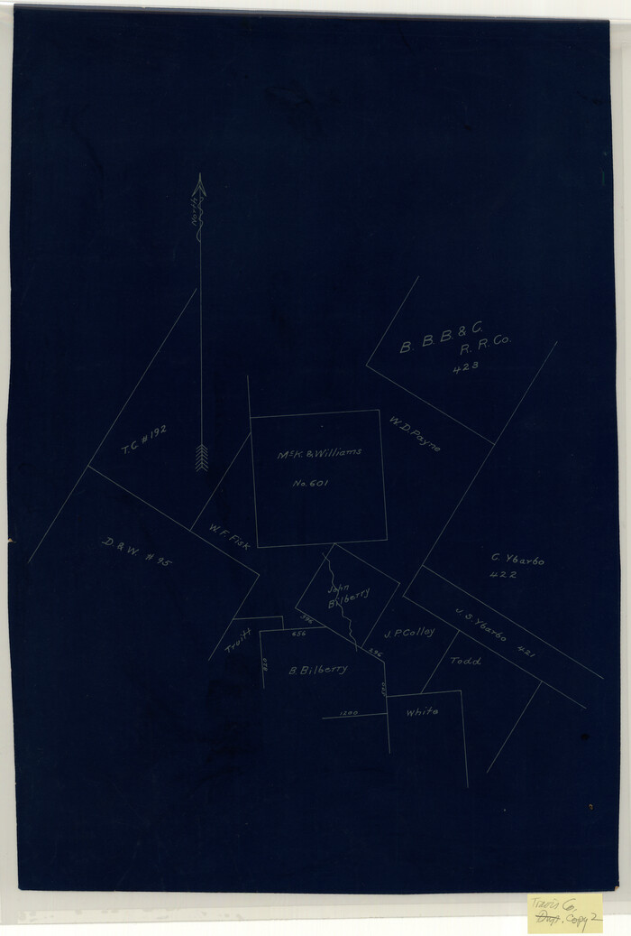
[McK. & Williams No. 601 and surrounding surveys, Travis County]
Print $20.00
- Digital $50.00
[McK. & Williams No. 601 and surrounding surveys, Travis County]
Size: 18.3 x 12.3 inches
10782
Blanco County Sketch File 12

Print $20.00
- Digital $50.00
Blanco County Sketch File 12
Size: 15.0 x 19.8 inches
10928
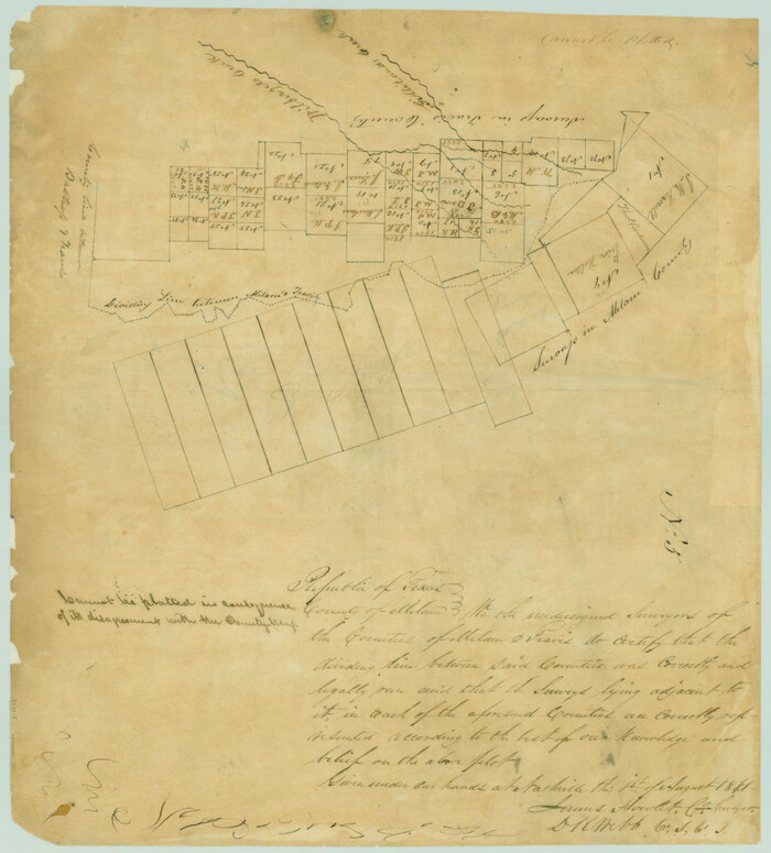
[Map of the dividing line between Milam and Travis Counties]
Print $20.00
- Digital $50.00
[Map of the dividing line between Milam and Travis Counties]
1841
Size: 14.2 x 12.8 inches
110
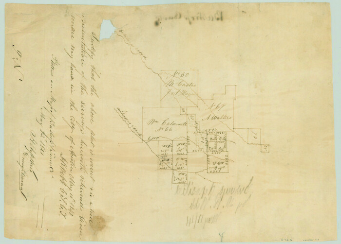
[Surveys along Gilleland and Wilbarger Creek in the Travis District]
Print $2.00
- Digital $50.00
[Surveys along Gilleland and Wilbarger Creek in the Travis District]
1841
Size: 8.1 x 11.2 inches
111
[Surveys in the Travis District along the Colorado and Pedernales Rivers]
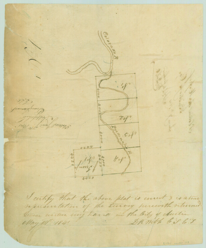
Print $2.00
- Digital $50.00
[Surveys in the Travis District along the Colorado and Pedernales Rivers]
1841
Size: 9.9 x 8.2 inches
113
[Surveys in the Travis District along the Colorado River]
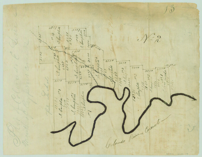
Print $2.00
- Digital $50.00
[Surveys in the Travis District along the Colorado River]
1840
Size: 8.0 x 10.2 inches
115
Hays County Sketch File 19a

Print $39.00
- Digital $50.00
Hays County Sketch File 19a
1894
Size: 19.4 x 28.6 inches
11749
Hays County Sketch File 28

Print $20.00
- Digital $50.00
Hays County Sketch File 28
1912
Size: 26.0 x 20.0 inches
11750
Travis County Sketch File 18

Print $20.00
- Digital $50.00
Travis County Sketch File 18
1872
Size: 24.2 x 25.4 inches
12458
Travis County Sketch File 29

Print $20.00
- Digital $50.00
Travis County Sketch File 29
1880
Size: 12.3 x 21.8 inches
12459
Travis County Sketch File 32

Print $20.00
- Digital $50.00
Travis County Sketch File 32
Size: 25.3 x 32.7 inches
12460
Travis County Sketch File 34

Print $26.00
- Digital $50.00
Travis County Sketch File 34
1888
Size: 26.8 x 27.9 inches
12461
Travis County Sketch File 38

Print $20.00
- Digital $50.00
Travis County Sketch File 38
1913
Size: 16.6 x 17.4 inches
12462
Travis County Rolled Sketch 3
Print $40.00
- Digital $50.00
Travis County Rolled Sketch 3
1902
-
Size
37.2 x 48.0 inches
-
Map/Doc
10009
-
Creation Date
1902
Travis County Rolled Sketch 15
Print $20.00
- Digital $50.00
Travis County Rolled Sketch 15
1939
-
Size
25.4 x 37.6 inches
-
Map/Doc
10011
-
Creation Date
1939
Travis County Rolled Sketch 19
Print $20.00
- Digital $50.00
Travis County Rolled Sketch 19
1940
-
Size
34.4 x 37.8 inches
-
Map/Doc
10012
-
Creation Date
1940
Travis County Rolled Sketch 32A
Print $40.00
- Digital $50.00
Travis County Rolled Sketch 32A
-
Size
57.6 x 37.3 inches
-
Map/Doc
10013
Travis County Rolled Sketch 37
Print $20.00
- Digital $50.00
Travis County Rolled Sketch 37
1942
-
Size
36.1 x 35.6 inches
-
Map/Doc
10014
-
Creation Date
1942
Travis County Rolled Sketch 47
Print $40.00
- Digital $50.00
Travis County Rolled Sketch 47
1925
-
Size
24.9 x 56.8 inches
-
Map/Doc
10016
-
Creation Date
1925
Travis County Rolled Sketch 49
Print $20.00
- Digital $50.00
Travis County Rolled Sketch 49
-
Size
43.0 x 39.9 inches
-
Map/Doc
10017
Travis County Rolled Sketch 55
Print $40.00
- Digital $50.00
Travis County Rolled Sketch 55
-
Size
43.1 x 50.5 inches
-
Map/Doc
10020
Travis County Rolled Sketch 44
Print $20.00
- Digital $50.00
Travis County Rolled Sketch 44
-
Size
34.2 x 35.6 inches
-
Map/Doc
10052
Travis County Rolled Sketch 32B
Print $20.00
- Digital $50.00
Travis County Rolled Sketch 32B
1948
-
Size
37.5 x 43.4 inches
-
Map/Doc
10310
-
Creation Date
1948
Travis County Rolled Sketch 47
Print $40.00
- Digital $50.00
Travis County Rolled Sketch 47
1923
-
Size
57.3 x 26.5 inches
-
Map/Doc
10626
-
Creation Date
1923
Travis County Rolled Sketch 47
Print $40.00
- Digital $50.00
Travis County Rolled Sketch 47
1928
-
Size
57.3 x 26.1 inches
-
Map/Doc
10627
-
Creation Date
1928
Travis County Rolled Sketch 47
Print $40.00
- Digital $50.00
Travis County Rolled Sketch 47
1931
-
Size
57.2 x 25.4 inches
-
Map/Doc
10628
-
Creation Date
1931
Travis County Rolled Sketch 37
Print $20.00
- Digital $50.00
Travis County Rolled Sketch 37
1942
-
Size
33.6 x 32.7 inches
-
Map/Doc
10737
-
Creation Date
1942
Map of the C.C. Browning survey 412 enlarged from General Land Office map of the west part of Travis County, Texas
Print $3.00
- Digital $50.00
Map of the C.C. Browning survey 412 enlarged from General Land Office map of the west part of Travis County, Texas
1920
-
Size
11.3 x 9.1 inches
-
Map/Doc
10752
-
Creation Date
1920
[Surveying sketch of S. Hayford, E. T. R.R. Co., T. C. R. R. Co., et al in Travis County, Texas]
Print $20.00
- Digital $50.00
[Surveying sketch of S. Hayford, E. T. R.R. Co., T. C. R. R. Co., et al in Travis County, Texas]
-
Size
18.0 x 17.3 inches
-
Map/Doc
10753
Map of the Western Part of Travis County, Texas
Print $20.00
- Digital $50.00
Map of the Western Part of Travis County, Texas
1919
-
Size
36.2 x 29.9 inches
-
Map/Doc
10754
-
Creation Date
1919
[McK. & Williams No. 601 and surrounding surveys, Travis County]
Print $20.00
- Digital $50.00
[McK. & Williams No. 601 and surrounding surveys, Travis County]
-
Size
18.3 x 12.3 inches
-
Map/Doc
10782
Blanco County Sketch File 12
Print $20.00
- Digital $50.00
Blanco County Sketch File 12
-
Size
15.0 x 19.8 inches
-
Map/Doc
10928
[Map of the dividing line between Milam and Travis Counties]
Print $20.00
- Digital $50.00
[Map of the dividing line between Milam and Travis Counties]
1841
-
Size
14.2 x 12.8 inches
-
Map/Doc
110
-
Creation Date
1841
[Surveys along Gilleland and Wilbarger Creek in the Travis District]
Print $2.00
- Digital $50.00
[Surveys along Gilleland and Wilbarger Creek in the Travis District]
1841
-
Size
8.1 x 11.2 inches
-
Map/Doc
111
-
Creation Date
1841
[Surveys in the Travis District along the Colorado and Pedernales Rivers]
Print $2.00
- Digital $50.00
[Surveys in the Travis District along the Colorado and Pedernales Rivers]
1841
-
Size
9.9 x 8.2 inches
-
Map/Doc
113
-
Creation Date
1841
[Surveys in the Travis District along the Colorado River]
Print $2.00
- Digital $50.00
[Surveys in the Travis District along the Colorado River]
1840
-
Size
8.0 x 10.2 inches
-
Map/Doc
115
-
Creation Date
1840
Hays County Sketch File 19a
Print $39.00
- Digital $50.00
Hays County Sketch File 19a
1894
-
Size
19.4 x 28.6 inches
-
Map/Doc
11749
-
Creation Date
1894
Hays County Sketch File 28
Print $20.00
- Digital $50.00
Hays County Sketch File 28
1912
-
Size
26.0 x 20.0 inches
-
Map/Doc
11750
-
Creation Date
1912
Travis County Sketch File 18
Print $20.00
- Digital $50.00
Travis County Sketch File 18
1872
-
Size
24.2 x 25.4 inches
-
Map/Doc
12458
-
Creation Date
1872
Travis County Sketch File 29
Print $20.00
- Digital $50.00
Travis County Sketch File 29
1880
-
Size
12.3 x 21.8 inches
-
Map/Doc
12459
-
Creation Date
1880
Travis County Sketch File 32
Print $20.00
- Digital $50.00
Travis County Sketch File 32
-
Size
25.3 x 32.7 inches
-
Map/Doc
12460
Travis County Sketch File 34
Print $26.00
- Digital $50.00
Travis County Sketch File 34
1888
-
Size
26.8 x 27.9 inches
-
Map/Doc
12461
-
Creation Date
1888
Travis County Sketch File 38
Print $20.00
- Digital $50.00
Travis County Sketch File 38
1913
-
Size
16.6 x 17.4 inches
-
Map/Doc
12462
-
Creation Date
1913