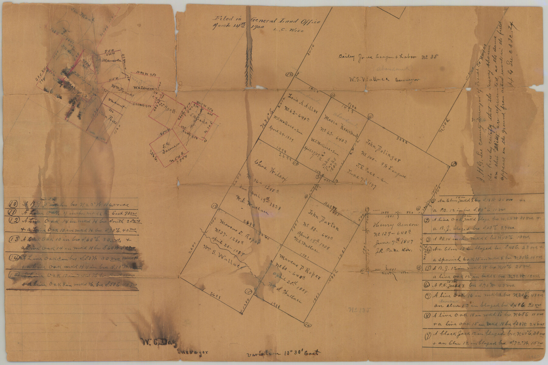
Travis County Sketch File 32
[Sketch of area around the Bolinger survey near the county boundary line with Hays County west of Austin]
-
Map/Doc
12460
-
Collection
General Map Collection
-
Object Dates
1900/3/14 (File Date)
1900/9/29 (Correspondence Date)
1899/12/30 (Survey Date)
-
People and Organizations
H.G. Lee (Surveyor/Engineer)
-
Counties
Travis Hays
-
Subjects
Surveying Sketch File
-
Height x Width
25.3 x 32.7 inches
64.3 x 83.1 cm
-
Medium
multi-page, multi-format
Part of: General Map Collection
Leon County Sketch File 31

Print $20.00
- Digital $50.00
Leon County Sketch File 31
Size 19.1 x 20.5 inches
Map/Doc 11993
Reeves County

Print $20.00
- Digital $50.00
Reeves County
1915
Size 46.5 x 35.7 inches
Map/Doc 16797
Controlled Mosaic by Jack Amman Photogrammetric Engineers, Inc - Sheet 36

Print $20.00
- Digital $50.00
Controlled Mosaic by Jack Amman Photogrammetric Engineers, Inc - Sheet 36
1954
Size 20.0 x 24.0 inches
Map/Doc 83489
Limestone County Working Sketch 26

Print $20.00
- Digital $50.00
Limestone County Working Sketch 26
1982
Size 39.6 x 44.1 inches
Map/Doc 70576
Brewster County Working Sketch 111

Print $40.00
- Digital $50.00
Brewster County Working Sketch 111
1982
Size 21.5 x 55.9 inches
Map/Doc 67711
Nolan County Sketch File 15

Print $20.00
- Digital $50.00
Nolan County Sketch File 15
1929
Size 24.5 x 22.6 inches
Map/Doc 42165
Leon County Rolled Sketch 26

Print $40.00
- Digital $50.00
Leon County Rolled Sketch 26
Size 24.0 x 54.5 inches
Map/Doc 9435
[Surveys East of river copied from U.S. map of Township No. 6 South, Range No. 9 West of the Indian Meridian, Oklahoma]
![75186, [Surveys East of river copied from U.S. map of Township No. 6 South, Range No. 9 West of the Indian Meridian, Oklahoma], General Map Collection](https://historictexasmaps.com/wmedia_w700/maps/75186.tif.jpg)
Print $2.00
- Digital $50.00
[Surveys East of river copied from U.S. map of Township No. 6 South, Range No. 9 West of the Indian Meridian, Oklahoma]
Size 13.3 x 9.2 inches
Map/Doc 75186
Kimble County Working Sketch 96

Print $20.00
- Digital $50.00
Kimble County Working Sketch 96
1921
Size 20.9 x 26.8 inches
Map/Doc 70164
Carson County Boundary File 10

Print $2.00
- Digital $50.00
Carson County Boundary File 10
Size 11.5 x 7.2 inches
Map/Doc 51185
Uvalde County Sketch File 30

Print $12.00
- Digital $50.00
Uvalde County Sketch File 30
1990
Size 4.4 x 9.9 inches
Map/Doc 39032
Hardeman County Sketch File A2

Print $20.00
- Digital $50.00
Hardeman County Sketch File A2
Size 28.5 x 17.3 inches
Map/Doc 11631
You may also like
Flight Mission No. CRC-5R, Frame 21, Chambers County

Print $20.00
- Digital $50.00
Flight Mission No. CRC-5R, Frame 21, Chambers County
1956
Size 18.6 x 22.3 inches
Map/Doc 84943
Glasscock County Sketch File 19

Print $20.00
- Digital $50.00
Glasscock County Sketch File 19
Size 21.4 x 16.8 inches
Map/Doc 11563
Nueces County Sketch File 54

Print $4.00
- Digital $50.00
Nueces County Sketch File 54
1856
Size 12.7 x 8.1 inches
Map/Doc 32865
Travis County Appraisal District Plat Map 2_0404

Print $20.00
- Digital $50.00
Travis County Appraisal District Plat Map 2_0404
Size 21.5 x 26.4 inches
Map/Doc 94229
The Republic County of Milam. Spring 1842

Print $20.00
The Republic County of Milam. Spring 1842
2020
Size 17.4 x 21.6 inches
Map/Doc 96232
Young County Working Sketch 18

Print $20.00
- Digital $50.00
Young County Working Sketch 18
1960
Size 23.9 x 29.2 inches
Map/Doc 62041
Harris County Working Sketch 5

Print $20.00
- Digital $50.00
Harris County Working Sketch 5
Size 35.1 x 28.0 inches
Map/Doc 65897
[Surveys in Austin's Colony along the Navasota River and Ten Mile Creek]
![80, [Surveys in Austin's Colony along the Navasota River and Ten Mile Creek], General Map Collection](https://historictexasmaps.com/wmedia_w700/maps/80.tif.jpg)
Print $20.00
- Digital $50.00
[Surveys in Austin's Colony along the Navasota River and Ten Mile Creek]
1821
Size 29.2 x 18.0 inches
Map/Doc 80
Upton County Sketch File 27

Print $20.00
- Digital $50.00
Upton County Sketch File 27
1928
Size 42.9 x 22.6 inches
Map/Doc 10416
Presidio County Boundary File 1

Print $22.00
- Digital $50.00
Presidio County Boundary File 1
Size 12.8 x 8.2 inches
Map/Doc 58041
Tom Green County Boundary File 6

Print $42.00
- Digital $50.00
Tom Green County Boundary File 6
Size 14.5 x 9.0 inches
Map/Doc 59376
Montague County Rolled Sketch 3

Print $20.00
- Digital $50.00
Montague County Rolled Sketch 3
1940
Size 24.0 x 15.9 inches
Map/Doc 6787