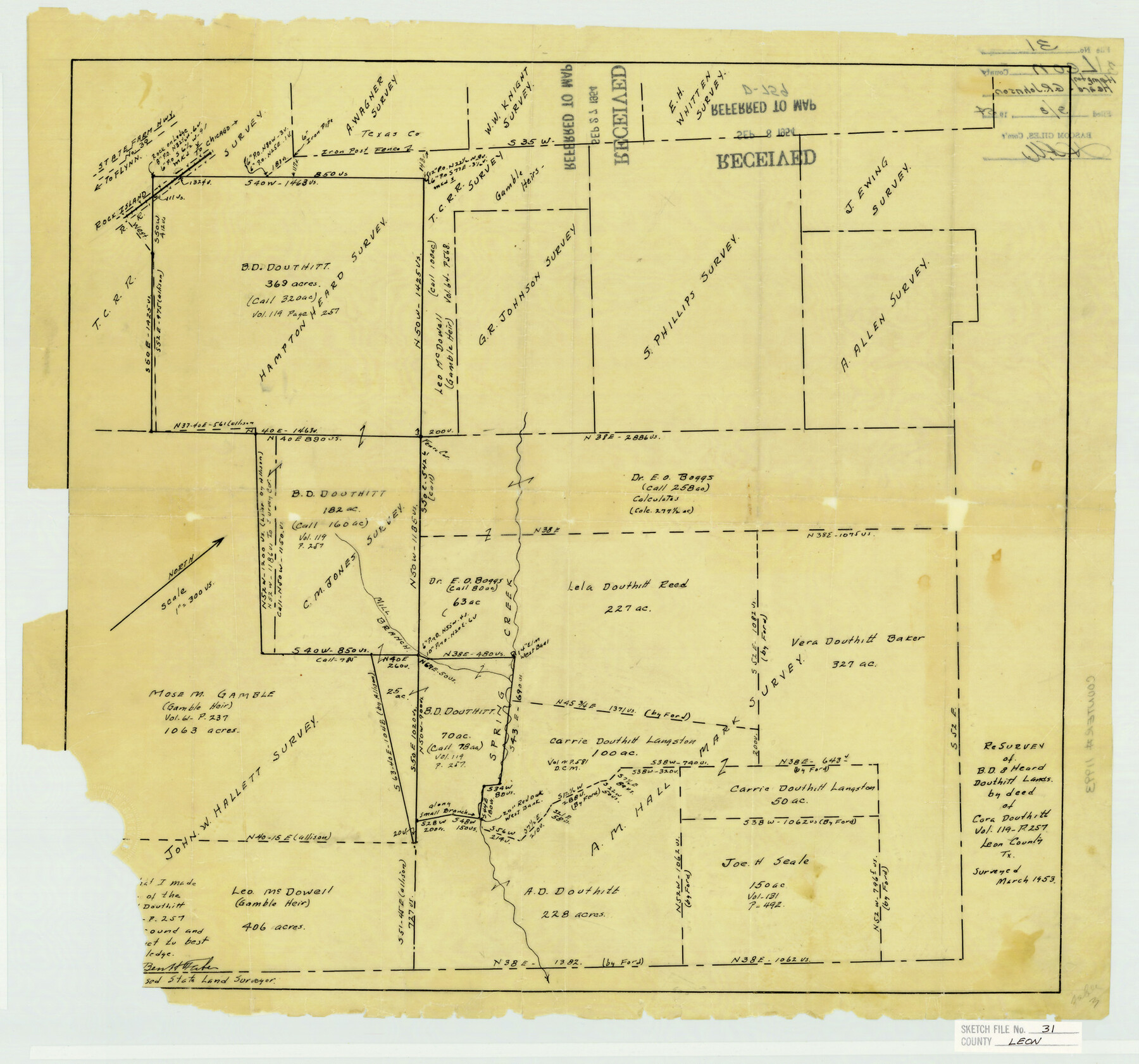
Leon County Sketch File 31
Resurvey of B. D. Heard Douthill Lands, Leon County, Texas
-
Map/Doc
11993
-
Collection
General Map Collection
-
Object Dates
9/8/1954 (File Date)
-
Counties
Leon
-
Subjects
Surveying Sketch File
-
Height x Width
19.1 x 20.5 inches
48.5 x 52.1 cm
-
Medium
paper, manuscript
-
Scale
1:300
Part of: General Map Collection
Parker County Sketch File 42

Print $114.00
- Digital $50.00
Parker County Sketch File 42
1877
Size 14.4 x 12.0 inches
Map/Doc 33589
Brown County Working Sketch 16

Print $20.00
- Digital $50.00
Brown County Working Sketch 16
1993
Size 46.3 x 34.7 inches
Map/Doc 67781
Glasscock County

Print $20.00
- Digital $50.00
Glasscock County
1933
Size 45.1 x 37.6 inches
Map/Doc 73158
Coast Chart No. 212 - From Latitude 26° 33' to the Rio Grande, Texas

Print $20.00
- Digital $50.00
Coast Chart No. 212 - From Latitude 26° 33' to the Rio Grande, Texas
1886
Size 37.8 x 34.1 inches
Map/Doc 73503
Robertson County Sketch File 12

Print $18.00
Robertson County Sketch File 12
1987
Size 11.4 x 8.8 inches
Map/Doc 35404
Stonewall County Working Sketch 27

Print $20.00
- Digital $50.00
Stonewall County Working Sketch 27
1976
Size 20.7 x 29.9 inches
Map/Doc 62334
Flight Mission No. CUG-1P, Frame 110, Kleberg County

Print $20.00
- Digital $50.00
Flight Mission No. CUG-1P, Frame 110, Kleberg County
1956
Size 18.5 x 22.2 inches
Map/Doc 86160
Terrell County Sketch File 37

Print $4.00
- Digital $50.00
Terrell County Sketch File 37
Size 14.5 x 9.1 inches
Map/Doc 37999
Tom Green County Working Sketch 4

Print $20.00
- Digital $50.00
Tom Green County Working Sketch 4
1948
Size 42.5 x 34.1 inches
Map/Doc 69373
[Right of Way Map, Belton Branch of the M.K.&T. RR.]
![64226, [Right of Way Map, Belton Branch of the M.K.&T. RR.], General Map Collection](https://historictexasmaps.com/wmedia_w700/maps/64226.tif.jpg)
Print $20.00
- Digital $50.00
[Right of Way Map, Belton Branch of the M.K.&T. RR.]
1896
Size 7.2 x 21.9 inches
Map/Doc 64226
[Map of Upshur County]
![[Map of Upshur County]](https://historictexasmaps.com/wmedia_w700/maps/4651.tif.jpg)
Print $20.00
- Digital $50.00
[Map of Upshur County]
1850
Size 25.2 x 17.8 inches
Map/Doc 4651
Houston County Working Sketch 36

Print $40.00
- Digital $50.00
Houston County Working Sketch 36
1987
Size 61.2 x 43.6 inches
Map/Doc 78231
You may also like
Topographical Map of the Rio Grande, Sheet No. 2

Print $20.00
- Digital $50.00
Topographical Map of the Rio Grande, Sheet No. 2
1912
Map/Doc 89526
Brewster County Working Sketch 98

Print $20.00
- Digital $50.00
Brewster County Working Sketch 98
1978
Size 44.9 x 28.5 inches
Map/Doc 67698

Montgomery County Sketch File 6b

Print $40.00
- Digital $50.00
Montgomery County Sketch File 6b
Size 12.8 x 16.2 inches
Map/Doc 31783
Hardin County Sketch File 61

Print $20.00
- Digital $50.00
Hardin County Sketch File 61
1933
Size 18.9 x 24.6 inches
Map/Doc 11636
Hopkins County Sketch File 3

Print $4.00
- Digital $50.00
Hopkins County Sketch File 3
Size 10.0 x 8.1 inches
Map/Doc 26685
Military Reconnaissance [showing forts along Rio Grande near Matamoros]
![72909, Military Reconnaissance [showing forts along Rio Grande near Matamoros], General Map Collection](https://historictexasmaps.com/wmedia_w700/maps/72909.tif.jpg)
Print $20.00
- Digital $50.00
Military Reconnaissance [showing forts along Rio Grande near Matamoros]
1846
Size 18.2 x 26.3 inches
Map/Doc 72909
Hutchinson County Rolled Sketch 44-7

Print $20.00
- Digital $50.00
Hutchinson County Rolled Sketch 44-7
2002
Size 24.0 x 36.0 inches
Map/Doc 77543
Hopkins County Sketch File 16

Print $4.00
- Digital $50.00
Hopkins County Sketch File 16
1870
Size 8.1 x 10.1 inches
Map/Doc 26713
Township No. 2 South Range No. 24 West of the Indian Meridian

Print $20.00
- Digital $50.00
Township No. 2 South Range No. 24 West of the Indian Meridian
1875
Size 19.3 x 24.4 inches
Map/Doc 75174
Right of Way and Track Map, The Missouri, Kansas and Texas Ry. of Texas operated by the Missouri, Kansas and Texas Ry. of Texas, Henrietta Division

Print $40.00
- Digital $50.00
Right of Way and Track Map, The Missouri, Kansas and Texas Ry. of Texas operated by the Missouri, Kansas and Texas Ry. of Texas, Henrietta Division
1918
Size 25.5 x 56.6 inches
Map/Doc 64070
San Patricio County Rolled Sketch 4

Print $20.00
- Digital $50.00
San Patricio County Rolled Sketch 4
1875
Size 18.4 x 28.8 inches
Map/Doc 7572