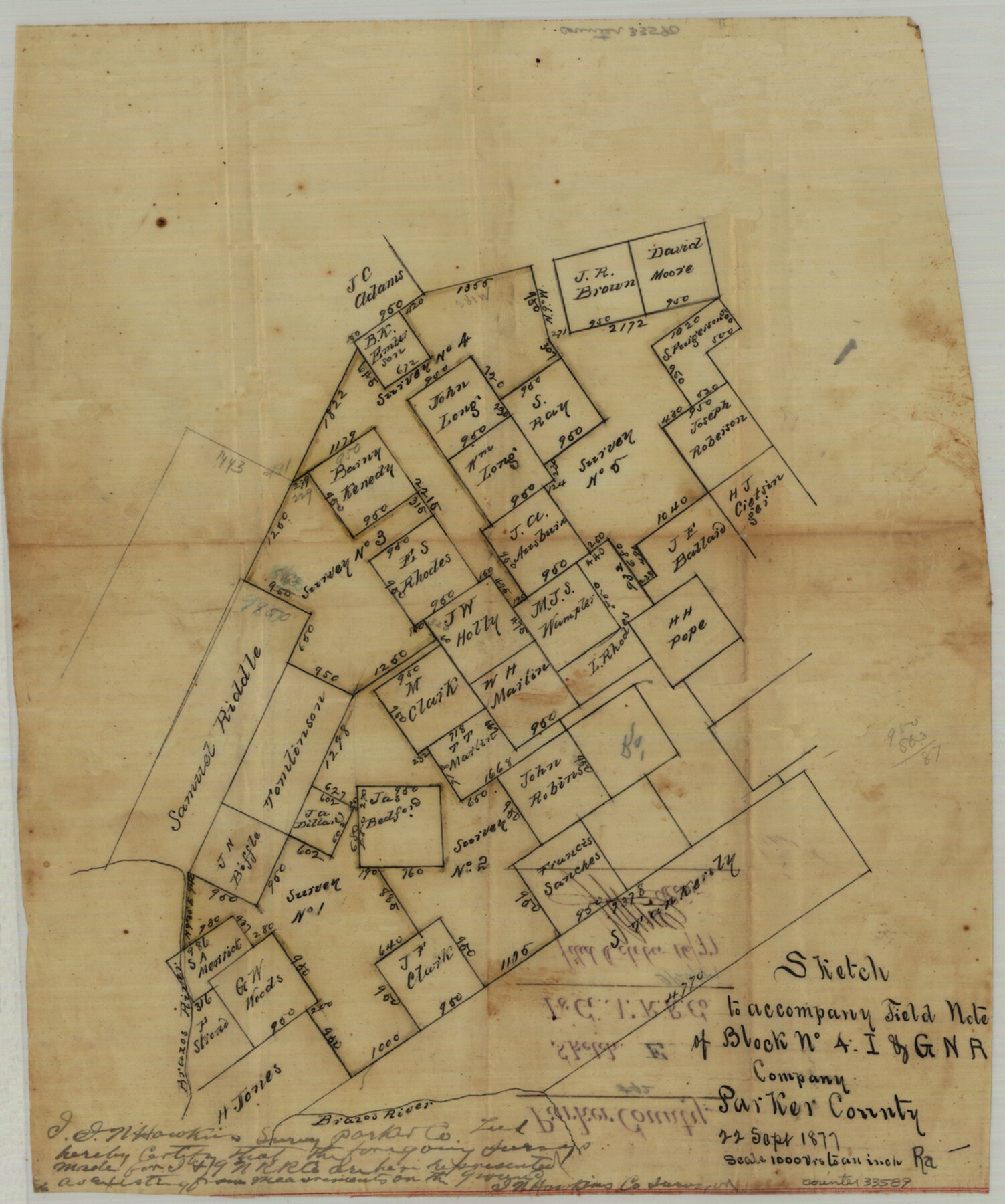
Parker County Sketch File 42
[Miscellaneous sketches of I. & G. N. RR. Co. surveys]
-
Map/Doc
33589
-
Collection
General Map Collection
-
Object Dates
10/16/1877 (File Date)
9/22/1877 (Creation Date)
8/17/1877 (Creation Date)
-
People and Organizations
I.N. Hawkins (Surveyor/Engineer)
-
Counties
Parker Hood
-
Subjects
Surveying Sketch File
-
Height x Width
14.4 x 12.0 inches
36.6 x 30.5 cm
-
Medium
paper, manuscript
-
Features
Brazos River
Part of: General Map Collection
Navarro County Sketch File 12

Print $4.00
- Digital $50.00
Navarro County Sketch File 12
Size 7.0 x 7.0 inches
Map/Doc 32322
Parker County Working Sketch 7

Print $20.00
- Digital $50.00
Parker County Working Sketch 7
1955
Map/Doc 71457
Sterling County Sketch File 7

Print $25.00
- Digital $50.00
Sterling County Sketch File 7
1926
Size 11.7 x 12.1 inches
Map/Doc 37121
El Paso County Working Sketch 48

Print $20.00
- Digital $50.00
El Paso County Working Sketch 48
1987
Size 32.7 x 29.4 inches
Map/Doc 69070
Hansford County Working Sketch 1

Print $40.00
- Digital $50.00
Hansford County Working Sketch 1
1934
Size 43.0 x 54.1 inches
Map/Doc 63373
Flight Mission No. CLL-3N, Frame 19, Willacy County

Print $20.00
- Digital $50.00
Flight Mission No. CLL-3N, Frame 19, Willacy County
1954
Size 18.4 x 22.1 inches
Map/Doc 87085
Hardeman County Working Sketch 13

Print $20.00
- Digital $50.00
Hardeman County Working Sketch 13
1966
Size 35.8 x 45.7 inches
Map/Doc 63394
[Sketch for Mineral Application 1112 - Colorado River, H. E. Chambers]
![65638, [Sketch for Mineral Application 1112 - Colorado River, H. E. Chambers], General Map Collection](https://historictexasmaps.com/wmedia_w700/maps/65638.tif.jpg)
Print $20.00
- Digital $50.00
[Sketch for Mineral Application 1112 - Colorado River, H. E. Chambers]
1918
Size 17.5 x 28.2 inches
Map/Doc 65638
San Patricio County Rolled Sketch 51

Print $40.00
- Digital $50.00
San Patricio County Rolled Sketch 51
1988
Size 41.8 x 54.6 inches
Map/Doc 10635
Flight Mission No. CRE-2R, Frame 154, Jackson County

Print $20.00
- Digital $50.00
Flight Mission No. CRE-2R, Frame 154, Jackson County
1956
Size 16.1 x 16.0 inches
Map/Doc 85365
Right of Way and Track Map, Houston & Texas Central R.R. operated by the T. and N. O. R.R., Fort Worth Branch

Print $40.00
- Digital $50.00
Right of Way and Track Map, Houston & Texas Central R.R. operated by the T. and N. O. R.R., Fort Worth Branch
1918
Size 31.7 x 56.8 inches
Map/Doc 64784
Presidio County Working Sketch 53

Print $20.00
- Digital $50.00
Presidio County Working Sketch 53
1955
Size 28.6 x 18.9 inches
Map/Doc 71730
You may also like
Sanderson and Terrell County, Texas

Sanderson and Terrell County, Texas
1920
Size 6.3 x 3.5 inches
Map/Doc 97073
Archer County Sketch File 8

Print $40.00
- Digital $50.00
Archer County Sketch File 8
Size 40.9 x 31.5 inches
Map/Doc 10336
Hutchinson County Working Sketch 43

Print $20.00
- Digital $50.00
Hutchinson County Working Sketch 43
1978
Size 26.6 x 22.3 inches
Map/Doc 66403
Dawson County Sketch File 6

Print $72.00
- Digital $50.00
Dawson County Sketch File 6
1927
Size 24.6 x 24.7 inches
Map/Doc 20518

Starr County Rolled Sketch 2

Print $40.00
- Digital $50.00
Starr County Rolled Sketch 2
1853
Size 31.7 x 48.5 inches
Map/Doc 9938
Map of Atascosa County

Print $20.00
- Digital $50.00
Map of Atascosa County
1879
Size 24.5 x 24.8 inches
Map/Doc 3250
Calhoun County Rolled Sketch 26

Print $40.00
- Digital $50.00
Calhoun County Rolled Sketch 26
1941
Size 25.5 x 112.1 inches
Map/Doc 8556
St. Louis, Brownsville & Mexico Railway Location map from Mile 40 to Mile 60

Print $40.00
- Digital $50.00
St. Louis, Brownsville & Mexico Railway Location map from Mile 40 to Mile 60
1905
Size 19.3 x 61.9 inches
Map/Doc 64080
Flight Mission No. DCL-6C, Frame 65, Kenedy County

Print $20.00
- Digital $50.00
Flight Mission No. DCL-6C, Frame 65, Kenedy County
1943
Size 18.5 x 22.3 inches
Map/Doc 85907
Jefferson County Sketch File 49

Print $40.00
- Digital $50.00
Jefferson County Sketch File 49
1955
Size 51.1 x 29.0 inches
Map/Doc 10508
Map of Robertson County

Print $20.00
- Digital $50.00
Map of Robertson County
1888
Size 29.1 x 23.9 inches
Map/Doc 83004