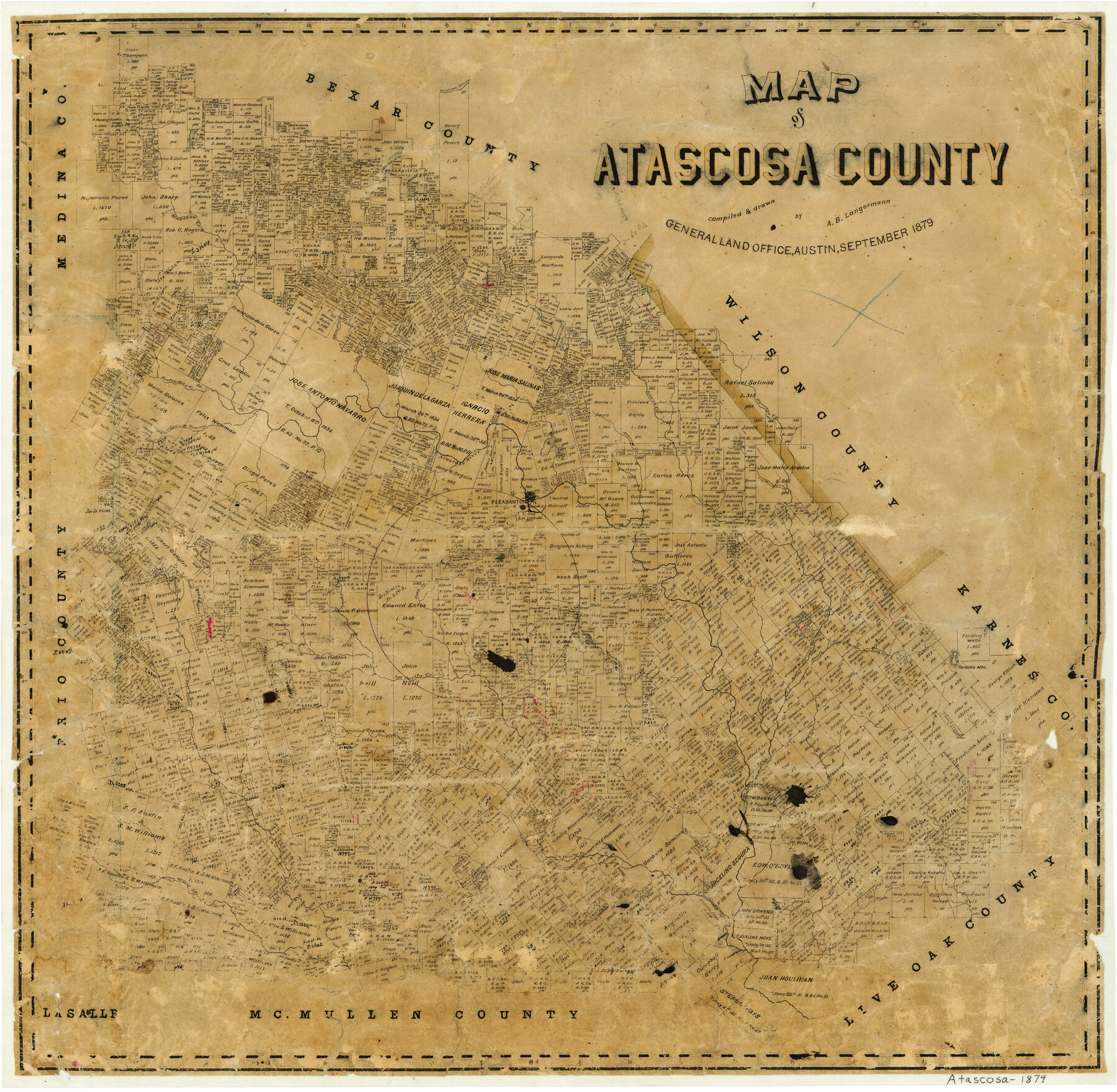
Map of Atascosa County
-
Map/Doc
3250
-
Collection
General Map Collection
-
Object Dates
9/1879 (Creation Date)
-
People and Organizations
A.B. Langermann (Compiler)
A.B. Langermann (Draftsman)
-
Counties
Atascosa
-
Subjects
County
-
Height x Width
24.5 x 24.8 inches
62.2 x 63.0 cm
-
Comments
Best candidate for copy. Nine black ink spots.
-
Features
Panther Creek
Lepan Creek
San Miguel Creek
Bell Creek
Salt Creek
Salinas Creek
Arroyo de Galvan
Las Priedas Creek
Clear Creek
Turkey Creek
Stoney Creek
East Matador Creek
Lagunieras Creek
Chiquihuitilla Creek
Maline Creek
Branch Creek
San Miguel Creek
Atascosa River
Atascosa Creek
Agua Negra
Sand Creek
Sesteadero Creek
Palo Alto Creek
Gallinas Creek
Lucus Creek
Borrego Creek
Medina River
Avarias Creek
Cañada de Padilla
Pleasanton
Goose Creek
La Parita Creek
Tordillo Creek
Tordilla Mountain
Part of: General Map Collection
Kinney County Sketch File 25

Print $20.00
- Digital $50.00
Kinney County Sketch File 25
1927
Size 19.1 x 18.9 inches
Map/Doc 11944
Gregg County Rolled Sketch 17

Print $20.00
- Digital $50.00
Gregg County Rolled Sketch 17
1933
Size 14.2 x 27.5 inches
Map/Doc 6041
Rusk County Working Sketch 11

Print $20.00
- Digital $50.00
Rusk County Working Sketch 11
1980
Size 33.3 x 32.0 inches
Map/Doc 63646
Tyler County Sketch File 22

Print $4.00
- Digital $50.00
Tyler County Sketch File 22
Size 8.5 x 9.3 inches
Map/Doc 38679
![94182, San Antonio [Verso], General Map Collection](https://historictexasmaps.com/wmedia_w700/maps/94182.tif.jpg)
Galveston County NRC Article 33.136 Sketch 79

Print $292.00
- Digital $50.00
Galveston County NRC Article 33.136 Sketch 79
2015
Size 22.0 x 34.0 inches
Map/Doc 94880
Maverick County Working Sketch 18

Print $20.00
- Digital $50.00
Maverick County Working Sketch 18
1975
Size 44.4 x 35.3 inches
Map/Doc 70910
[Surveys on Galveston and East Bay]
![248, [Surveys on Galveston and East Bay], General Map Collection](https://historictexasmaps.com/wmedia_w700/maps/248.tif.jpg)
Print $2.00
- Digital $50.00
[Surveys on Galveston and East Bay]
1846
Size 8.8 x 7.9 inches
Map/Doc 248
Map of McClennan County

Print $20.00
- Digital $50.00
Map of McClennan County
1868
Size 22.8 x 25.4 inches
Map/Doc 3861
Panola County Working Sketch 24

Print $20.00
- Digital $50.00
Panola County Working Sketch 24
1957
Map/Doc 71433
Gillespie County Working Sketch 12

Print $20.00
- Digital $50.00
Gillespie County Working Sketch 12
2007
Size 37.6 x 38.0 inches
Map/Doc 87903
Bexar County Sketch File 36a

Print $10.00
- Digital $50.00
Bexar County Sketch File 36a
1873
Size 11.3 x 8.8 inches
Map/Doc 14507
You may also like
Burnet County Working Sketch 22

Print $40.00
- Digital $50.00
Burnet County Working Sketch 22
1986
Size 40.5 x 50.9 inches
Map/Doc 67865
Gaines County Working Sketch 8

Print $20.00
- Digital $50.00
Gaines County Working Sketch 8
1951
Size 21.8 x 24.8 inches
Map/Doc 69308
Webb County Working Sketch 57

Print $20.00
- Digital $50.00
Webb County Working Sketch 57
1958
Size 24.9 x 38.0 inches
Map/Doc 72423
[North 3/4 of County]
![90840, [North 3/4 of County], Twichell Survey Records](https://historictexasmaps.com/wmedia_w700/maps/90840-2.tif.jpg)
Print $20.00
- Digital $50.00
[North 3/4 of County]
1887
Size 26.0 x 15.4 inches
Map/Doc 90840
Amérique Septentrionale

Print $20.00
Amérique Septentrionale
1845
Size 13.8 x 20.3 inches
Map/Doc 94571
Wharton County Sketch File 11

Print $4.00
- Digital $50.00
Wharton County Sketch File 11
1891
Size 9.1 x 12.3 inches
Map/Doc 39933
Hudspeth County Working Sketch 51

Print $20.00
- Digital $50.00
Hudspeth County Working Sketch 51
Size 32.8 x 24.5 inches
Map/Doc 66336
[Beaumont, Sour Lake and Western Ry. Right of Way and Alignment - Frisco]
![64133, [Beaumont, Sour Lake and Western Ry. Right of Way and Alignment - Frisco], General Map Collection](https://historictexasmaps.com/wmedia_w700/maps/64133.tif.jpg)
Print $20.00
- Digital $50.00
[Beaumont, Sour Lake and Western Ry. Right of Way and Alignment - Frisco]
1910
Size 20.0 x 45.5 inches
Map/Doc 64133

Walker County Boundary File 1

Print $54.00
- Digital $50.00
Walker County Boundary File 1
Size 14.4 x 8.9 inches
Map/Doc 59655
C. B. Livestock Co.'s West-Ranch, Bailey County, Texas

Print $2.00
- Digital $50.00
C. B. Livestock Co.'s West-Ranch, Bailey County, Texas
Size 8.8 x 11.2 inches
Map/Doc 90380
Flight Mission No. BQY-15M, Frame 20, Harris County

Print $20.00
- Digital $50.00
Flight Mission No. BQY-15M, Frame 20, Harris County
1953
Size 18.6 x 22.3 inches
Map/Doc 85318