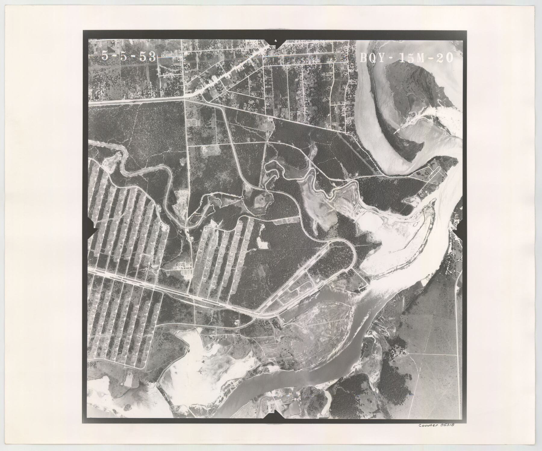
Flight Mission No. BQY-15M, Frame 20, Harris County
BQY-15M-20
-
Map/Doc
85318
-
Collection
General Map Collection
-
Object Dates
1953/5/5 (Creation Date)
-
People and Organizations
U. S. Department of Agriculture (Publisher)
-
Counties
Harris
-
Subjects
Aerial Photograph
-
Height x Width
18.6 x 22.3 inches
47.2 x 56.6 cm
-
Comments
Flown by Jack Ammann Photogrammetric Engineers of San Antonio, Texas.
Part of: General Map Collection
Presidio County Sketch File 48

Print $6.00
- Digital $50.00
Presidio County Sketch File 48
1918
Size 15.1 x 11.0 inches
Map/Doc 34582
Tom Green County Working Sketch 9

Print $20.00
- Digital $50.00
Tom Green County Working Sketch 9
1951
Size 31.3 x 42.2 inches
Map/Doc 69378
Pecos County Sketch File 73

Print $48.00
- Digital $50.00
Pecos County Sketch File 73
1940
Size 8.9 x 9.1 inches
Map/Doc 33876
[F. W. & D. C. Ry. Co. Alignment and Right of Way Map, Clay County]
![64727, [F. W. & D. C. Ry. Co. Alignment and Right of Way Map, Clay County], General Map Collection](https://historictexasmaps.com/wmedia_w700/maps/64727-1.tif.jpg)
Print $20.00
- Digital $50.00
[F. W. & D. C. Ry. Co. Alignment and Right of Way Map, Clay County]
1927
Size 18.6 x 11.7 inches
Map/Doc 64727
Hudspeth County Sketch File 52

Print $100.00
- Digital $50.00
Hudspeth County Sketch File 52
1983
Size 10.9 x 31.2 inches
Map/Doc 11807
Flight Mission No. BRE-1P, Frame 97, Nueces County

Print $20.00
- Digital $50.00
Flight Mission No. BRE-1P, Frame 97, Nueces County
1956
Size 18.3 x 22.0 inches
Map/Doc 86668
Trinity County

Print $20.00
- Digital $50.00
Trinity County
1882
Size 17.1 x 24.6 inches
Map/Doc 4097
Coryell County Working Sketch 32

Print $20.00
- Digital $50.00
Coryell County Working Sketch 32
2022
Size 25.3 x 36.9 inches
Map/Doc 96966
Flight Mission No. BRA-3M, Frame 201, Jefferson County

Print $20.00
- Digital $50.00
Flight Mission No. BRA-3M, Frame 201, Jefferson County
1953
Size 18.7 x 22.5 inches
Map/Doc 85416
Wilbarger County Aerial Photograph Index Sheet 4

Print $20.00
- Digital $50.00
Wilbarger County Aerial Photograph Index Sheet 4
1950
Size 21.7 x 18.8 inches
Map/Doc 83753
Montague County Working Sketch 32

Print $20.00
- Digital $50.00
Montague County Working Sketch 32
1975
Size 26.0 x 26.1 inches
Map/Doc 71098
Eastland County Rolled Sketch 19

Print $20.00
- Digital $50.00
Eastland County Rolled Sketch 19
1980
Size 28.9 x 30.9 inches
Map/Doc 8825
You may also like
Dimmit County Sketch File 56

Print $20.00
- Digital $50.00
Dimmit County Sketch File 56
1939
Size 15.8 x 27.4 inches
Map/Doc 11360
[Jack District]
![16828, [Jack District], General Map Collection](https://historictexasmaps.com/wmedia_w700/maps/16828.tif.jpg)
Print $40.00
- Digital $50.00
[Jack District]
1876
Size 50.0 x 76.4 inches
Map/Doc 16828
Aransas Pass to Baffin Bay

Print $20.00
- Digital $50.00
Aransas Pass to Baffin Bay
1961
Size 42.1 x 35.4 inches
Map/Doc 73414
Flight Mission No. BRE-2P, Frame 111, Nueces County

Print $20.00
- Digital $50.00
Flight Mission No. BRE-2P, Frame 111, Nueces County
1956
Size 18.4 x 22.6 inches
Map/Doc 86797
El Paso County Sketch File 19

Print $30.00
- Digital $50.00
El Paso County Sketch File 19
1905
Size 13.3 x 8.7 inches
Map/Doc 22009
Aransas County Rolled Sketch 1

Print $40.00
- Digital $50.00
Aransas County Rolled Sketch 1
1930
Size 54.3 x 17.0 inches
Map/Doc 8914

[Surveys in the Bexar and San Patricio Districts along the Nueces and Frio Rivers]
![36, [Surveys in the Bexar and San Patricio Districts along the Nueces and Frio Rivers], General Map Collection](https://historictexasmaps.com/wmedia_w700/maps/36.tif.jpg)
Print $20.00
- Digital $50.00
[Surveys in the Bexar and San Patricio Districts along the Nueces and Frio Rivers]
1830
Size 21.5 x 27.3 inches
Map/Doc 36
Santa Fe Lines - Texas, Oklahoma, and Louisiana

Print $20.00
- Digital $50.00
Santa Fe Lines - Texas, Oklahoma, and Louisiana
1923
Size 9.3 x 8.3 inches
Map/Doc 96595
Oldham County Working Sketch 9

Print $20.00
- Digital $50.00
Oldham County Working Sketch 9
1982
Size 33.3 x 37.2 inches
Map/Doc 71331
Coast Chart No. 211 - Padre I. and Laguna Madre Lat. 27° 12' to Lat. 26° 33' Texas

Print $20.00
- Digital $50.00
Coast Chart No. 211 - Padre I. and Laguna Madre Lat. 27° 12' to Lat. 26° 33' Texas
1890
Size 27.5 x 18.2 inches
Map/Doc 72824
Flight Mission No. BQY-4M, Frame 57, Harris County

Print $20.00
- Digital $50.00
Flight Mission No. BQY-4M, Frame 57, Harris County
1953
Size 18.5 x 22.3 inches
Map/Doc 85266