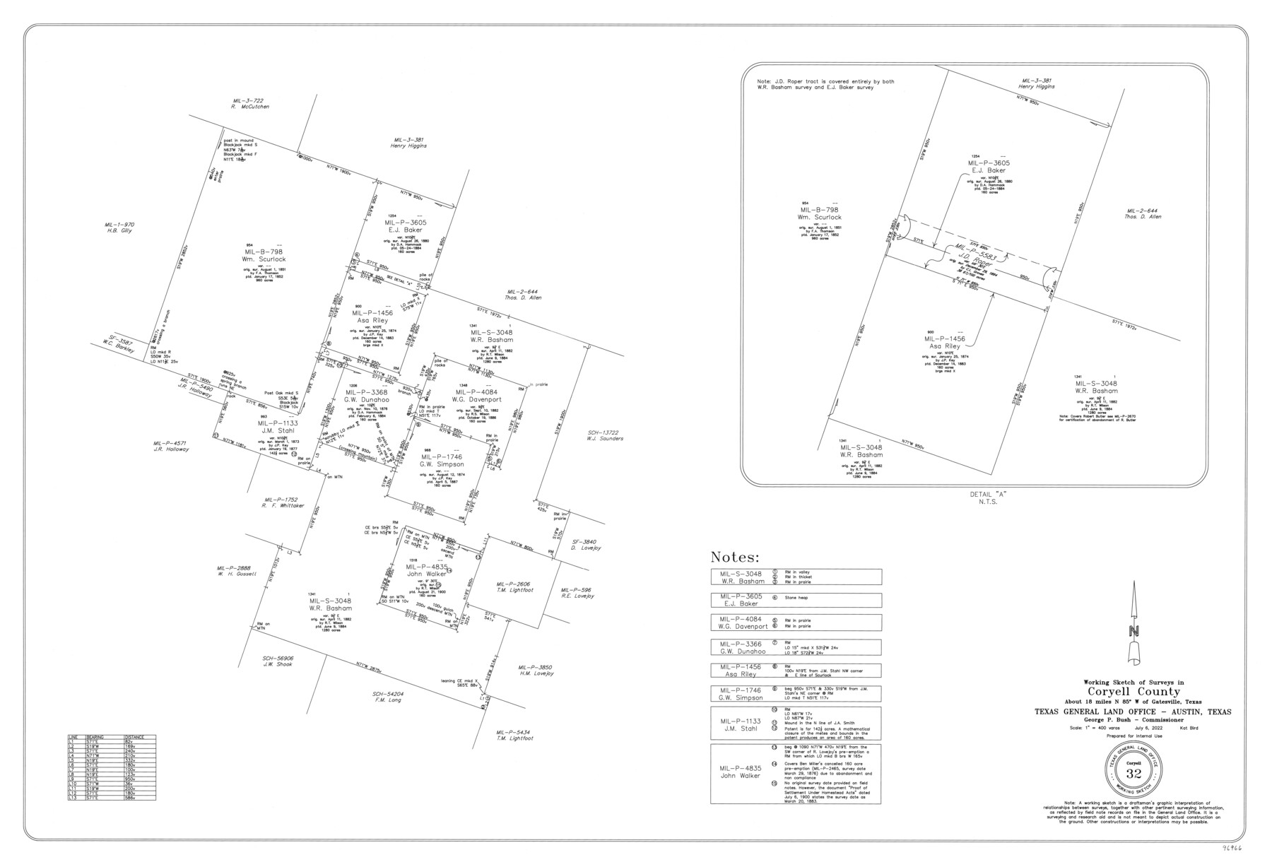
Coryell County Working Sketch 32
-
Map/Doc
96966
-
Collection
General Map Collection
-
Object Dates
7/6/2022 (Creation Date)
-
People and Organizations
Kat Bird (Draftsman)
-
Counties
Coryell
-
Subjects
Surveying Working Sketch
-
Height x Width
25.3 x 36.9 inches
64.3 x 93.7 cm
-
Medium
mylar, print
-
Scale
1" = 400 varas
Part of: General Map Collection
Hidalgo County Sketch File 11

Print $40.00
- Digital $50.00
Hidalgo County Sketch File 11
1908
Size 18.5 x 13.6 inches
Map/Doc 26429
Ector County Working Sketch 30

Print $40.00
- Digital $50.00
Ector County Working Sketch 30
1971
Size 43.2 x 64.1 inches
Map/Doc 68873
Jefferson County Working Sketch 9

Print $20.00
- Digital $50.00
Jefferson County Working Sketch 9
1937
Size 19.5 x 22.0 inches
Map/Doc 66552
Blanco County Working Sketch 19

Print $20.00
- Digital $50.00
Blanco County Working Sketch 19
1960
Size 24.4 x 29.2 inches
Map/Doc 67379
PSF Field Notes for Blocks 42 1/2 and 43 in Culberson and Hudspeth Counties, and Blocks 30 through 41 in Hudspeth County

PSF Field Notes for Blocks 42 1/2 and 43 in Culberson and Hudspeth Counties, and Blocks 30 through 41 in Hudspeth County
Map/Doc 81660
Sherman County Boundary File 4

Print $54.00
- Digital $50.00
Sherman County Boundary File 4
Size 8.9 x 8.5 inches
Map/Doc 58782
Kerr County Rolled Sketch 11A

Print $20.00
- Digital $50.00
Kerr County Rolled Sketch 11A
1950
Size 27.8 x 36.0 inches
Map/Doc 6496
Taylor County Working Sketch 4a

Print $20.00
- Digital $50.00
Taylor County Working Sketch 4a
1944
Size 17.2 x 14.0 inches
Map/Doc 69613
Wood County Working Sketch 10

Print $20.00
- Digital $50.00
Wood County Working Sketch 10
1943
Size 29.6 x 30.4 inches
Map/Doc 62010
Tyler County Working Sketch 6

Print $20.00
- Digital $50.00
Tyler County Working Sketch 6
1934
Size 24.3 x 36.5 inches
Map/Doc 69476
Flight Mission No. CRC-3R, Frame 37, Chambers County

Print $20.00
- Digital $50.00
Flight Mission No. CRC-3R, Frame 37, Chambers County
1956
Size 18.6 x 22.4 inches
Map/Doc 84810
Galveston County Rolled Sketch Z61

Print $20.00
- Digital $50.00
Galveston County Rolled Sketch Z61
1934
Size 34.9 x 23.0 inches
Map/Doc 5993
You may also like
Hunt County Boundary File 11

Print $14.00
- Digital $50.00
Hunt County Boundary File 11
Size 11.3 x 8.9 inches
Map/Doc 55266
Duval County Sketch File 85

Print $27.00
- Digital $50.00
Duval County Sketch File 85
1935
Size 14.3 x 9.1 inches
Map/Doc 21534
Blanco County Working Sketch 13

Print $20.00
- Digital $50.00
Blanco County Working Sketch 13
1948
Size 42.6 x 33.6 inches
Map/Doc 67373
Walker County Working Sketch 14

Print $40.00
- Digital $50.00
Walker County Working Sketch 14
1958
Size 19.8 x 51.0 inches
Map/Doc 72294
Gonzales County

Print $40.00
- Digital $50.00
Gonzales County
1986
Size 41.6 x 54.7 inches
Map/Doc 73160

Red River County Working Sketch 80

Print $20.00
- Digital $50.00
Red River County Working Sketch 80
1982
Size 24.1 x 29.3 inches
Map/Doc 72063
Aransas County Aerial Photograph Index Sheet 4

Print $20.00
- Digital $50.00
Aransas County Aerial Photograph Index Sheet 4
1957
Size 23.6 x 16.1 inches
Map/Doc 83662
Flight Mission No. BQR-5K, Frame 69, Brazoria County

Print $20.00
- Digital $50.00
Flight Mission No. BQR-5K, Frame 69, Brazoria County
1952
Size 18.8 x 22.4 inches
Map/Doc 84014
Cass County Working Sketch 40

Print $20.00
- Digital $50.00
Cass County Working Sketch 40
1984
Size 24.6 x 24.5 inches
Map/Doc 67943
Map of a part of Fisher and Miller's Colony - Harvey's District

Print $20.00
- Digital $50.00
Map of a part of Fisher and Miller's Colony - Harvey's District
1856
Size 19.0 x 24.7 inches
Map/Doc 4657
Flight Mission No. CLL-3N, Frame 41, Willacy County

Print $20.00
- Digital $50.00
Flight Mission No. CLL-3N, Frame 41, Willacy County
1954
Size 18.4 x 22.1 inches
Map/Doc 87099