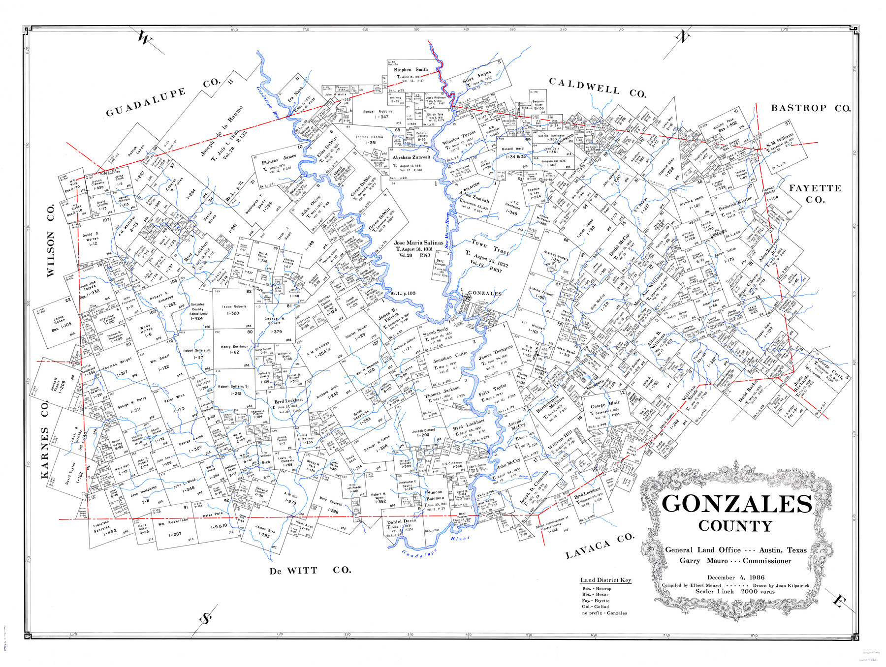
Gonzales County
-
Map/Doc
73160
-
Collection
General Map Collection
-
Object Dates
12/4/1986 (Creation Date)
-
People and Organizations
Garry Mauro (GLO Commissioner)
Elbert Menzel (Compiler)
Joan Kilpatrick (Draftsman)
-
Counties
Gonzales
-
Subjects
County
-
Height x Width
41.6 x 54.7 inches
105.7 x 138.9 cm
-
Scale
1" = 2000 varas
-
Comments
Leroy lettered.
-
Features
Barton Creek
Waelder
GH&SA
Sandy Fork [of Peach Creek]
Toms Creek
Rocky Creek
Mourin
Harwood
Canoe Creek
Slayden
Gonzales
Peach Creek
Elm Fork [of Rocky Creek]
Denton Creek
Smith Creek
Town Creek
San Marcos River
Mule Creek
Plum Creek
Salt Fork
Nash Creek
Guadalupe River
Castleman Fork [of Sandies Creek]
Part of: General Map Collection
Karnes County Working Sketch 10

Print $20.00
- Digital $50.00
Karnes County Working Sketch 10
1970
Size 35.5 x 26.3 inches
Map/Doc 66658
Wood County Boundary File 3

Print $10.00
- Digital $50.00
Wood County Boundary File 3
Size 12.4 x 8.5 inches
Map/Doc 60162
Duval County Rolled Sketch Pressly No. 1A

Print $20.00
- Digital $50.00
Duval County Rolled Sketch Pressly No. 1A
1935
Size 25.4 x 37.6 inches
Map/Doc 5769
Scarborough's Topographic Map of Massachusetts showing railroads, electric railways, steamboat lines, highways, post offices, villages, etc. completely indexed

Print $40.00
- Digital $50.00
Scarborough's Topographic Map of Massachusetts showing railroads, electric railways, steamboat lines, highways, post offices, villages, etc. completely indexed
1903
Size 39.8 x 59.4 inches
Map/Doc 97107

Real County Working Sketch 22

Print $20.00
- Digital $50.00
Real County Working Sketch 22
1945
Size 20.0 x 21.7 inches
Map/Doc 71914
Upshur County Working Sketch 9

Print $20.00
- Digital $50.00
Upshur County Working Sketch 9
1963
Size 27.9 x 17.7 inches
Map/Doc 69565
Map of Nolan County

Print $20.00
- Digital $50.00
Map of Nolan County
1902
Size 47.4 x 37.5 inches
Map/Doc 5021
Concho County Rolled Sketch 12

Print $40.00
- Digital $50.00
Concho County Rolled Sketch 12
1958
Size 36.4 x 50.6 inches
Map/Doc 8657

Mitchell County Sketch File 11

Print $6.00
- Digital $50.00
Mitchell County Sketch File 11
1910
Size 11.2 x 8.8 inches
Map/Doc 31700
Hood County Working Sketch 27

Print $20.00
- Digital $50.00
Hood County Working Sketch 27
1995
Size 24.6 x 38.0 inches
Map/Doc 66221
You may also like
General Highway Map. Detail of Cities and Towns in Navarro County, Texas

Print $20.00
General Highway Map. Detail of Cities and Towns in Navarro County, Texas
1961
Size 19.3 x 25.0 inches
Map/Doc 79611

[D. Boone, Block A27]
![92640, [D. Boone, Block A27], Twichell Survey Records](https://historictexasmaps.com/wmedia_w700/maps/92640-1.tif.jpg)
Print $20.00
- Digital $50.00
[D. Boone, Block A27]
Size 37.0 x 24.0 inches
Map/Doc 92640
Matagorda County Working Sketch 4

Print $20.00
- Digital $50.00
Matagorda County Working Sketch 4
1908
Size 33.1 x 32.0 inches
Map/Doc 70862
Reconnoissance of Sabine River and Valley

Print $20.00
Reconnoissance of Sabine River and Valley
1863
Size 42.3 x 30.0 inches
Map/Doc 97501
Part of Laguna Madre in Cameron County, showing Subdivision for Mineral Development

Print $20.00
- Digital $50.00
Part of Laguna Madre in Cameron County, showing Subdivision for Mineral Development
1963
Size 45.8 x 36.0 inches
Map/Doc 1926
Old Miscellaneous File 13

Print $6.00
- Digital $50.00
Old Miscellaneous File 13
1899
Size 9.7 x 6.5 inches
Map/Doc 75446
Gaines County Rolled Sketch 9

Print $20.00
- Digital $50.00
Gaines County Rolled Sketch 9
Size 20.9 x 29.8 inches
Map/Doc 5929
Wood County Rolled Sketch 6

Print $20.00
- Digital $50.00
Wood County Rolled Sketch 6
1952
Size 29.7 x 21.2 inches
Map/Doc 8284
Burnet County Working Sketch 13

Print $40.00
- Digital $50.00
Burnet County Working Sketch 13
1977
Size 40.5 x 49.2 inches
Map/Doc 67856
Irion County Working Sketch 16

Print $20.00
- Digital $50.00
Irion County Working Sketch 16
1973
Size 37.8 x 36.7 inches
Map/Doc 66425
Liberty County Sketch File 41

Print $2.00
- Digital $50.00
Liberty County Sketch File 41
1872
Size 12.5 x 8.5 inches
Map/Doc 29997