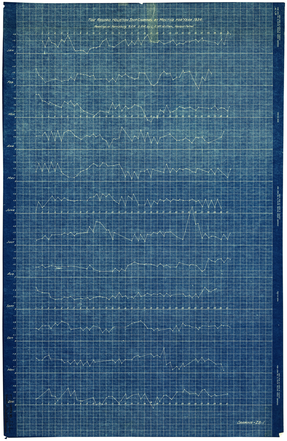
Galveston County Rolled Sketch Z61
Tide Record Houston Ship Channel by months for year 1934 - Readings at Harrisburg 8 A.M. - 5 P.M.
-
Map/Doc
5993
-
Collection
General Map Collection
-
Object Dates
1934 (Creation Date)
7/25/1935 (File Date)
-
People and Organizations
L.A. McMillian (Surveyor/Engineer)
-
Counties
Galveston
-
Subjects
Surveying Rolled Sketch
-
Height x Width
34.9 x 23.0 inches
88.7 x 58.4 cm
-
Medium
blueprint/diazo
Part of: General Map Collection
Shackelford County Working Sketch 7

Print $20.00
- Digital $50.00
Shackelford County Working Sketch 7
1963
Size 22.4 x 23.3 inches
Map/Doc 63847
Cherokee County Rolled Sketch 2

Print $20.00
- Digital $50.00
Cherokee County Rolled Sketch 2
1954
Size 44.6 x 36.0 inches
Map/Doc 8596

Map of Moser Ranch, Bowie County, Texas

Print $20.00
- Digital $50.00
Map of Moser Ranch, Bowie County, Texas
Size 29.0 x 27.4 inches
Map/Doc 73558
Nueces County Rolled Sketch 74

Print $32.00
Nueces County Rolled Sketch 74
1981
Size 18.4 x 25.3 inches
Map/Doc 6932
[Right of Way & Track Map, The Texas & Pacific Ry. Co. Main Line]
![64665, [Right of Way & Track Map, The Texas & Pacific Ry. Co. Main Line], General Map Collection](https://historictexasmaps.com/wmedia_w700/maps/64665.tif.jpg)
Print $20.00
- Digital $50.00
[Right of Way & Track Map, The Texas & Pacific Ry. Co. Main Line]
Size 11.0 x 18.4 inches
Map/Doc 64665
Lynn County Sketch File 9

Print $4.00
- Digital $50.00
Lynn County Sketch File 9
1904
Size 11.2 x 8.7 inches
Map/Doc 30475
Kimble County Working Sketch 50

Print $20.00
- Digital $50.00
Kimble County Working Sketch 50
1952
Size 34.8 x 22.1 inches
Map/Doc 70118
Bee County Working Sketch 9

Print $20.00
- Digital $50.00
Bee County Working Sketch 9
1940
Size 15.6 x 16.8 inches
Map/Doc 67259
Brewster County Rolled Sketch 114

Print $20.00
- Digital $50.00
Brewster County Rolled Sketch 114
1964
Size 11.9 x 18.3 inches
Map/Doc 5290
Burleson County Working Sketch 18

Print $20.00
- Digital $50.00
Burleson County Working Sketch 18
1980
Size 17.6 x 7.8 inches
Map/Doc 67737
[Surveys in the Bexar District along the Medina River west of the San Antonio River]
![57, [Surveys in the Bexar District along the Medina River west of the San Antonio River], General Map Collection](https://historictexasmaps.com/wmedia_w700/maps/57.tif.jpg)
Print $2.00
- Digital $50.00
[Surveys in the Bexar District along the Medina River west of the San Antonio River]
1842
Size 8.0 x 15.2 inches
Map/Doc 57
You may also like
Sketch in Martin County Showing Survey 13, Block X

Print $2.00
- Digital $50.00
Sketch in Martin County Showing Survey 13, Block X
1908
Size 12.6 x 8.4 inches
Map/Doc 91286
Flight Mission No. BRA-16M, Frame 130, Jefferson County

Print $20.00
- Digital $50.00
Flight Mission No. BRA-16M, Frame 130, Jefferson County
1953
Size 18.5 x 22.5 inches
Map/Doc 85740
Gregg County Rolled Sketch 9

Print $20.00
- Digital $50.00
Gregg County Rolled Sketch 9
1933
Size 38.0 x 29.8 inches
Map/Doc 6034
Map of the upper surveys in Robertson's Colony Sold by the State of Coahuila and Texas

Print $20.00
- Digital $50.00
Map of the upper surveys in Robertson's Colony Sold by the State of Coahuila and Texas
Size 26.8 x 22.0 inches
Map/Doc 82
Archer County Working Sketch 1a

Print $20.00
- Digital $50.00
Archer County Working Sketch 1a
Size 42.8 x 42.5 inches
Map/Doc 83096
Duval County Working Sketch 11

Print $20.00
- Digital $50.00
Duval County Working Sketch 11
1937
Size 24.3 x 19.4 inches
Map/Doc 68724
Zapata County Sketch File 13

Print $4.00
- Digital $50.00
Zapata County Sketch File 13
1930
Size 11.3 x 8.8 inches
Map/Doc 40952
San Jacinto County Working Sketch 31

Print $20.00
- Digital $50.00
San Jacinto County Working Sketch 31
1953
Size 29.1 x 30.4 inches
Map/Doc 63744
Flight Mission No. CRC-5R, Frame 16, Chambers County

Print $20.00
- Digital $50.00
Flight Mission No. CRC-5R, Frame 16, Chambers County
1956
Size 18.6 x 22.4 inches
Map/Doc 84938
Parker County Sketch File 12

Print $4.00
- Digital $50.00
Parker County Sketch File 12
1858
Size 9.1 x 7.1 inches
Map/Doc 33544
Jack County Sketch File 9a

Print $6.00
- Digital $50.00
Jack County Sketch File 9a
1857
Size 12.5 x 7.8 inches
Map/Doc 27522
Dallas County Working Sketch Graphic Index

Print $20.00
- Digital $50.00
Dallas County Working Sketch Graphic Index
1942
Size 43.9 x 36.7 inches
Map/Doc 76517