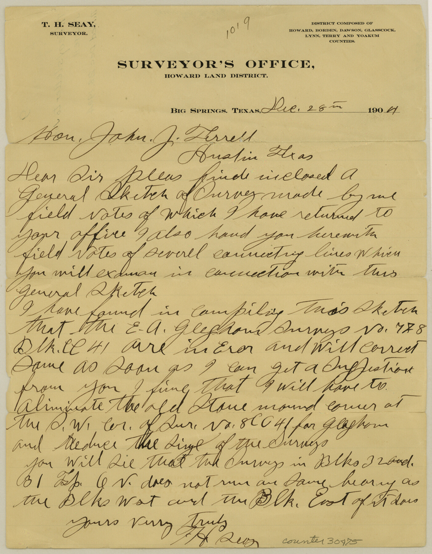
Lynn County Sketch File 9
[Letter to John J. Terrell]
-
Map/Doc
30475
-
Collection
General Map Collection
-
Object Dates
12/28/1904 (Creation Date)
12/28/1904 (Correspondence Date)
-
People and Organizations
T.H. Seay (Surveyor/Engineer)
T.H. Seay (Draftsman)
-
Counties
Lynn
-
Subjects
Surveying Sketch File
-
Height x Width
11.2 x 8.7 inches
28.4 x 22.1 cm
-
Medium
paper, manuscript
Part of: General Map Collection
[Aerial photograph from Carancahua Bend of Caney Creek to Cedar Lake]
![78641, [Aerial photograph from Carancahua Bend of Caney Creek to Cedar Lake], General Map Collection](https://historictexasmaps.com/wmedia_w700/maps/78641.tif.jpg)
Print $20.00
- Digital $50.00
[Aerial photograph from Carancahua Bend of Caney Creek to Cedar Lake]
1991
Size 24.5 x 31.9 inches
Map/Doc 78641
San Patricio County Rolled Sketch 54

Print $20.00
- Digital $50.00
San Patricio County Rolled Sketch 54
1995
Size 25.3 x 36.5 inches
Map/Doc 7740
Aransas County Sketch File 37

Print $139.00
- Digital $50.00
Aransas County Sketch File 37
1995
Size 11.1 x 9.1 inches
Map/Doc 13413
Roberts County Working Sketch 23

Print $20.00
- Digital $50.00
Roberts County Working Sketch 23
1979
Size 19.7 x 12.9 inches
Map/Doc 63549
Flight Mission No. BQY-4M, Frame 120, Harris County

Print $20.00
- Digital $50.00
Flight Mission No. BQY-4M, Frame 120, Harris County
1953
Size 18.5 x 22.3 inches
Map/Doc 85288
Kimble County Rolled Sketch 21

Print $20.00
- Digital $50.00
Kimble County Rolled Sketch 21
Size 10.5 x 18.2 inches
Map/Doc 6512
In the Supreme Court of the United States, The State of Oklahoma, Complainant vs. The State of Texas, Defendant, The United States of America, Intervener, Red River Valley, Texas and Oklahoma Between the 98th and 100th Meridians in Five Sheets, 1921

Print $40.00
- Digital $50.00
In the Supreme Court of the United States, The State of Oklahoma, Complainant vs. The State of Texas, Defendant, The United States of America, Intervener, Red River Valley, Texas and Oklahoma Between the 98th and 100th Meridians in Five Sheets, 1921
1921
Size 37.7 x 60.2 inches
Map/Doc 75277
Trinity River, Potter Bridge Sheet/Kings Creek

Print $20.00
- Digital $50.00
Trinity River, Potter Bridge Sheet/Kings Creek
1928
Size 42.1 x 34.0 inches
Map/Doc 65220
Flight Mission No. DIX-10P, Frame 144, Aransas County

Print $20.00
- Digital $50.00
Flight Mission No. DIX-10P, Frame 144, Aransas County
1956
Size 18.6 x 22.3 inches
Map/Doc 83946
Nueces County Rolled Sketch 125

Print $34.00
Nueces County Rolled Sketch 125
1998
Size 18.1 x 25.0 inches
Map/Doc 7160
Baylor County Sketch File 23a

Print $10.00
- Digital $50.00
Baylor County Sketch File 23a
1927
Size 14.3 x 8.9 inches
Map/Doc 14204
Hutchinson County Working Sketch 48

Print $20.00
- Digital $50.00
Hutchinson County Working Sketch 48
1981
Size 36.7 x 29.5 inches
Map/Doc 66408
You may also like
Robertson County Sketch File 11

Print $12.00
Robertson County Sketch File 11
Size 9.4 x 7.9 inches
Map/Doc 35398
Flight Mission No. CRE-1R, Frame 135, Jackson County

Print $20.00
- Digital $50.00
Flight Mission No. CRE-1R, Frame 135, Jackson County
1956
Size 16.2 x 15.8 inches
Map/Doc 85343
San Jacinto County Working Sketch 35

Print $20.00
- Digital $50.00
San Jacinto County Working Sketch 35
1955
Size 31.3 x 32.1 inches
Map/Doc 63748
Wise County Sketch File 1

Print $4.00
- Digital $50.00
Wise County Sketch File 1
1855
Size 11.9 x 7.6 inches
Map/Doc 40521
Leon County Rolled Sketch 10

Print $20.00
- Digital $50.00
Leon County Rolled Sketch 10
1962
Size 30.9 x 37.2 inches
Map/Doc 6598
McCulloch County Working Sketch Graphic Index

Print $20.00
- Digital $50.00
McCulloch County Working Sketch Graphic Index
1949
Size 47.3 x 37.4 inches
Map/Doc 76636
Frio County Sketch File 22

Print $10.00
- Digital $50.00
Frio County Sketch File 22
1994
Size 11.4 x 8.6 inches
Map/Doc 23162
Harris County Historic Topographic 23

Print $20.00
- Digital $50.00
Harris County Historic Topographic 23
1916
Size 29.2 x 22.6 inches
Map/Doc 65834
Hidalgo County Sketch File 14

Print $20.00
- Digital $50.00
Hidalgo County Sketch File 14
Size 29.6 x 24.5 inches
Map/Doc 11764
Cass County Sketch File 19

Print $40.00
- Digital $50.00
Cass County Sketch File 19
1893
Size 15.7 x 12.6 inches
Map/Doc 17422
Flight Mission No. DCL-7C, Frame 60, Kenedy County

Print $20.00
- Digital $50.00
Flight Mission No. DCL-7C, Frame 60, Kenedy County
1943
Size 15.3 x 15.3 inches
Map/Doc 86048
[Surveys near Onion Creek]
![108, [Surveys near Onion Creek], General Map Collection](https://historictexasmaps.com/wmedia_w700/maps/108-1.tif.jpg)
Print $2.00
- Digital $50.00
[Surveys near Onion Creek]
1841
Size 11.0 x 7.8 inches
Map/Doc 108