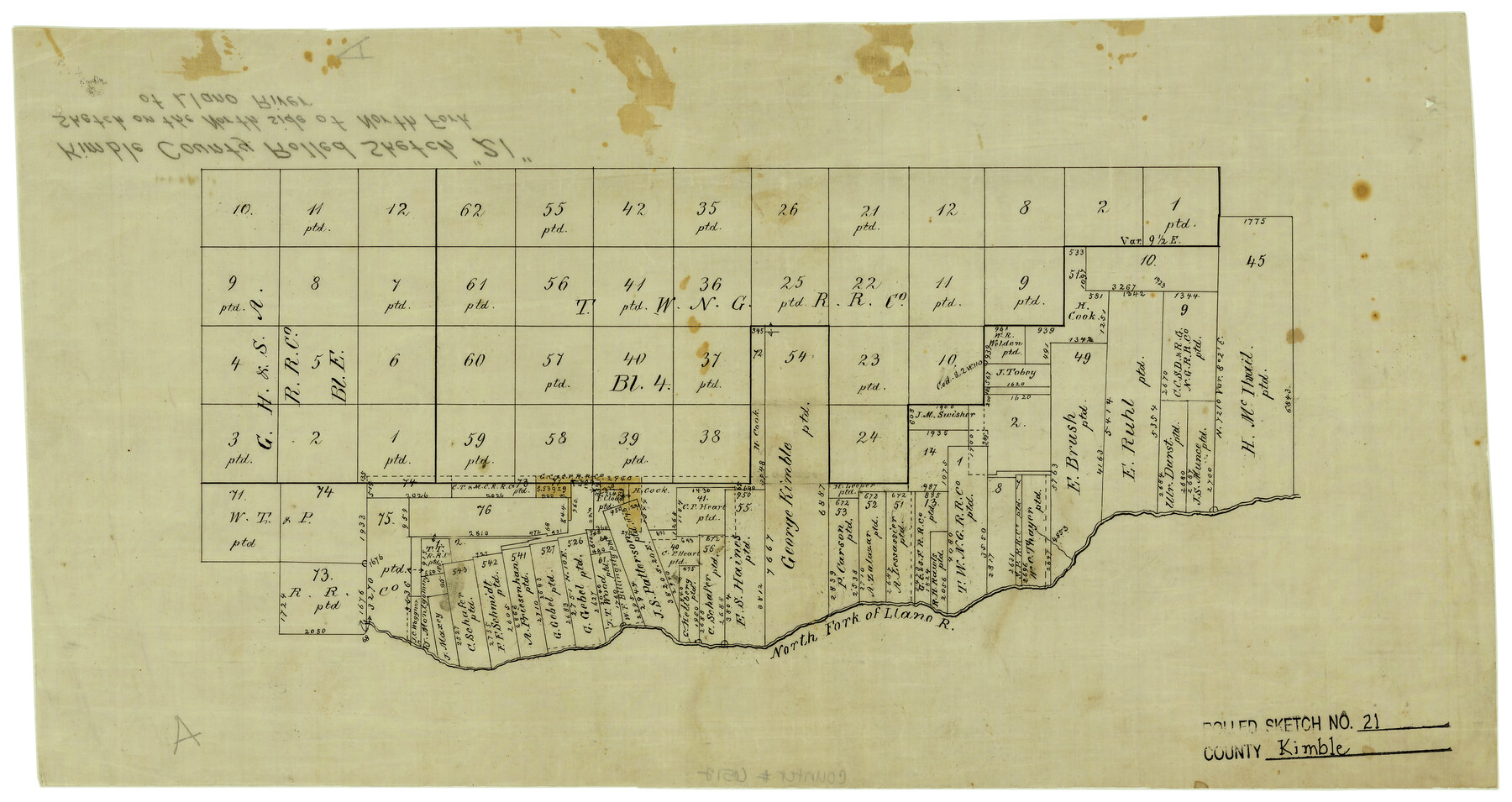
Kimble County Rolled Sketch 21
[Sketch on the north side of north fork of Llano River]
-
Map/Doc
6512
-
Collection
General Map Collection
-
Counties
Kimble
-
Subjects
Surveying Rolled Sketch
-
Height x Width
10.5 x 18.2 inches
26.7 x 46.2 cm
-
Medium
linen, manuscript
Part of: General Map Collection
La Salle County Working Sketch 46

Print $20.00
- Digital $50.00
La Salle County Working Sketch 46
1981
Size 15.9 x 20.2 inches
Map/Doc 70347
Limestone County Working Sketch 6

Print $20.00
- Digital $50.00
Limestone County Working Sketch 6
1922
Size 31.5 x 33.3 inches
Map/Doc 70556
Gregg County Boundary File 8

Print $8.00
- Digital $50.00
Gregg County Boundary File 8
Size 14.0 x 8.6 inches
Map/Doc 54019
Hemphill County Working Sketch 31

Print $20.00
- Digital $50.00
Hemphill County Working Sketch 31
1974
Size 38.8 x 41.1 inches
Map/Doc 66126
Throckmorton County Working Sketch 7

Print $20.00
- Digital $50.00
Throckmorton County Working Sketch 7
1956
Size 25.8 x 32.0 inches
Map/Doc 62116
Hansford County

Print $20.00
- Digital $50.00
Hansford County
1932
Size 41.8 x 39.8 inches
Map/Doc 1847
Map of Chocolate Bay, west portion of West Bay & vicinity, Brazoria & Galveston Counties showing subdivision for mineral development

Print $40.00
- Digital $50.00
Map of Chocolate Bay, west portion of West Bay & vicinity, Brazoria & Galveston Counties showing subdivision for mineral development
1948
Size 42.2 x 55.2 inches
Map/Doc 2974
Flight Mission No. CGN-3P, Frame 140, San Patricio County

Print $20.00
- Digital $50.00
Flight Mission No. CGN-3P, Frame 140, San Patricio County
1956
Size 18.5 x 22.3 inches
Map/Doc 86984
Chambers County NRC Article 33.136 Sketch 9

Print $24.00
- Digital $50.00
Chambers County NRC Article 33.136 Sketch 9
2014
Size 17.7 x 24.0 inches
Map/Doc 94747
Runnels County Sketch File 36

Print $20.00
Runnels County Sketch File 36
1889
Size 20.9 x 19.6 inches
Map/Doc 12267
Anderson County Boundary File 3

Print $9.00
- Digital $50.00
Anderson County Boundary File 3
Size 14.3 x 8.8 inches
Map/Doc 49733
Hunt County Sketch File 33

Print $4.00
- Digital $50.00
Hunt County Sketch File 33
1864
Size 7.1 x 5.0 inches
Map/Doc 27141
You may also like
Galveston County Sketch File 11

Print $40.00
- Digital $50.00
Galveston County Sketch File 11
Size 16.3 x 13.2 inches
Map/Doc 23374
Stonewall County Rolled Sketch 32

Print $20.00
- Digital $50.00
Stonewall County Rolled Sketch 32
1951
Size 19.1 x 33.4 inches
Map/Doc 7877
Sherman County, Texas

Print $20.00
- Digital $50.00
Sherman County, Texas
Size 19.1 x 18.8 inches
Map/Doc 753
Frio County Working Sketch 4

Print $20.00
- Digital $50.00
Frio County Working Sketch 4
1924
Size 26.4 x 27.2 inches
Map/Doc 69278
Jeff Davis County Working Sketch Graphic Index - central part

Print $40.00
- Digital $50.00
Jeff Davis County Working Sketch Graphic Index - central part
1982
Size 55.7 x 42.6 inches
Map/Doc 76593
Coleman County Sketch File 28

Print $6.00
- Digital $50.00
Coleman County Sketch File 28
1873
Size 10.2 x 15.8 inches
Map/Doc 18716
Gonzales County Rolled Sketch 2

Print $20.00
- Digital $50.00
Gonzales County Rolled Sketch 2
2021
Size 24.0 x 35.9 inches
Map/Doc 96581
Connected Map of Austin's Colony

Print $20.00
- Digital $50.00
Connected Map of Austin's Colony
1833
Size 38.1 x 36.1 inches
Map/Doc 88999

Webb County Rolled Sketch 53

Print $40.00
- Digital $50.00
Webb County Rolled Sketch 53
1944
Size 83.5 x 28.6 inches
Map/Doc 49483
Clay County Sketch File 15

Print $4.00
- Digital $50.00
Clay County Sketch File 15
1873
Size 12.8 x 8.4 inches
Map/Doc 18419
Baylor County Rolled Sketch 12

Print $20.00
- Digital $50.00
Baylor County Rolled Sketch 12
1986
Size 22.4 x 36.0 inches
Map/Doc 5129