Runnels County Sketch File 36
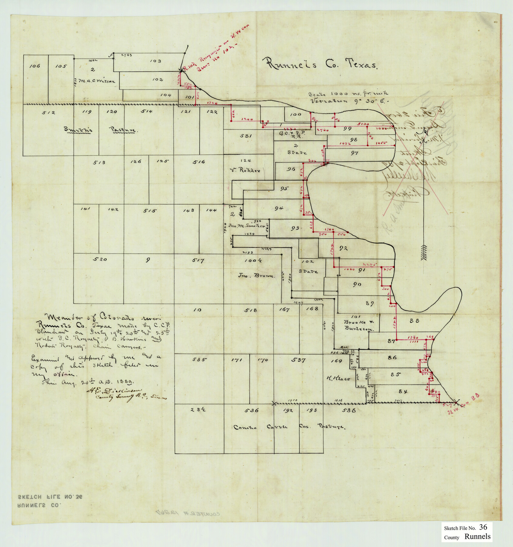
[Sketch of surveys west of the Colorado River in the southeast part of Runnels County, Texas]
-
Map/Doc
12267
-
Collection
General Map Collection
-
Object Dates
8/20/1889 (Creation Date)
7/1889 (Survey Date)
-
People and Organizations
C.C.F. Blanchard (Surveyor/Engineer)
-
Counties
Runnels
-
Subjects
Surveying Sketch File
-
Height x Width
20.9 x 19.6 inches
53.1 x 49.8 cm
-
Medium
paper, manuscript
-
Scale
1" = 1000 varas
-
Features
Colorado River
Part of: General Map Collection
Loving County Rolled Sketch 17

Print $40.00
- Digital $50.00
Loving County Rolled Sketch 17
2022
Size 38.2 x 49.3 inches
Map/Doc 97292
Marion County Working Sketch 12a

Print $20.00
- Digital $50.00
Marion County Working Sketch 12a
1953
Size 23.9 x 33.2 inches
Map/Doc 70788
Sulphur River, Talco Sheet

Print $20.00
- Digital $50.00
Sulphur River, Talco Sheet
1917
Size 12.5 x 25.5 inches
Map/Doc 78336
Throckmorton County Sketch File 7a

Print $6.00
- Digital $50.00
Throckmorton County Sketch File 7a
1898
Size 13.9 x 6.7 inches
Map/Doc 38094
Floyd County Rolled Sketch 9

Print $323.00
- Digital $50.00
Floyd County Rolled Sketch 9
1953
Size 10.0 x 15.7 inches
Map/Doc 44564
McCulloch County

Print $20.00
- Digital $50.00
McCulloch County
1874
Size 21.9 x 16.8 inches
Map/Doc 3856
Wichita County Rolled Sketch 12

Print $20.00
- Digital $50.00
Wichita County Rolled Sketch 12
Size 20.2 x 22.3 inches
Map/Doc 8249
Flight Mission No. DAG-21K, Frame 133, Matagorda County

Print $20.00
- Digital $50.00
Flight Mission No. DAG-21K, Frame 133, Matagorda County
1952
Size 18.6 x 22.4 inches
Map/Doc 86459
Travis County Boundary File 32

Print $5.00
- Digital $50.00
Travis County Boundary File 32
Size 11.8 x 9.4 inches
Map/Doc 59473
McMullen County Working Sketch 54

Print $20.00
- Digital $50.00
McMullen County Working Sketch 54
1983
Size 25.3 x 29.0 inches
Map/Doc 70755
Leon County Rolled Sketch 26

Print $40.00
- Digital $50.00
Leon County Rolled Sketch 26
Size 24.0 x 54.5 inches
Map/Doc 9435
El Paso County Sketch File 5

Print $20.00
- Digital $50.00
El Paso County Sketch File 5
Size 25.3 x 18.9 inches
Map/Doc 11450
You may also like
Cooke County Sketch File 8

Print $4.00
- Digital $50.00
Cooke County Sketch File 8
Size 8.2 x 8.4 inches
Map/Doc 19235
Orange County Sketch File 30

Print $20.00
- Digital $50.00
Orange County Sketch File 30
1926
Size 22.7 x 34.4 inches
Map/Doc 12124
Potter County Boundary File 1b

Print $8.00
- Digital $50.00
Potter County Boundary File 1b
Size 14.4 x 8.4 inches
Map/Doc 57948
Shelby County Sketch File 5

Print $22.00
- Digital $50.00
Shelby County Sketch File 5
Size 8.4 x 12.1 inches
Map/Doc 36599
Greater Texas and the Coast Country - The Winter Garden

Greater Texas and the Coast Country - The Winter Garden
1911
Size 9.4 x 4.5 inches
Map/Doc 97057
Palo Pinto County Sketch File 6

Print $40.00
- Digital $50.00
Palo Pinto County Sketch File 6
1875
Size 9.3 x 18.8 inches
Map/Doc 33396
Kerr County Rolled Sketch 25

Print $20.00
- Digital $50.00
Kerr County Rolled Sketch 25
Size 24.7 x 31.0 inches
Map/Doc 6505
Presidio County Sketch File 118

Print $16.00
- Digital $50.00
Presidio County Sketch File 118
Size 14.3 x 8.9 inches
Map/Doc 34919
Morris County Rolled Sketch 2A

Print $20.00
- Digital $50.00
Morris County Rolled Sketch 2A
Size 22.7 x 17.7 inches
Map/Doc 10227
General Highway Map, Lee County, Texas

Print $20.00
General Highway Map, Lee County, Texas
1961
Size 18.4 x 24.6 inches
Map/Doc 79567
Travis County Appraisal District Plat Map 2_2814

Print $20.00
- Digital $50.00
Travis County Appraisal District Plat Map 2_2814
Size 21.6 x 26.4 inches
Map/Doc 94218
Shelby County Shelby District

Print $20.00
- Digital $50.00
Shelby County Shelby District
1880
Size 20.5 x 25.3 inches
Map/Doc 4030