El Paso County Sketch File 5
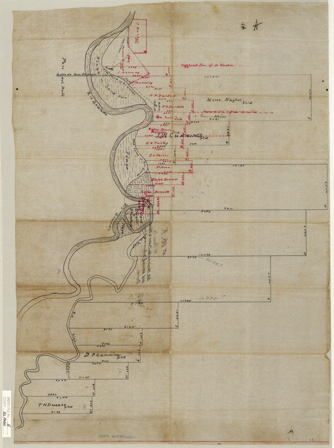
Sk. Showing the Owen & Blanchard Island, & Surrounding Surs.
-
Map/Doc
11450
-
Collection
General Map Collection
-
Counties
El Paso
-
Subjects
Surveying Sketch File
-
Height x Width
25.3 x 18.9 inches
64.3 x 48.0 cm
-
Medium
paper, manuscript
-
Features
Calle de San Antonio
Rio Grande
Rio Viejo
Part of: General Map Collection
Tyler County Sketch File 15

Print $6.00
- Digital $50.00
Tyler County Sketch File 15
1857
Size 10.4 x 7.5 inches
Map/Doc 38658
Comal County Working Sketch 5

Print $20.00
- Digital $50.00
Comal County Working Sketch 5
1950
Size 19.0 x 21.4 inches
Map/Doc 68171
Brazoria County Rolled Sketch 43

Print $20.00
- Digital $50.00
Brazoria County Rolled Sketch 43
Size 24.4 x 19.6 inches
Map/Doc 5177
Nueces County Sketch File 56

Print $113.00
- Digital $50.00
Nueces County Sketch File 56
1973
Size 10.1 x 9.3 inches
Map/Doc 32874
Gregg County Sketch File 1D

Print $4.00
- Digital $50.00
Gregg County Sketch File 1D
1848
Size 12.7 x 8.5 inches
Map/Doc 24543
Liberty County Working Sketch 15

Print $20.00
- Digital $50.00
Liberty County Working Sketch 15
1922
Size 19.0 x 15.0 inches
Map/Doc 70474
Leon County Sketch File 7

Print $6.00
- Digital $50.00
Leon County Sketch File 7
1858
Size 12.4 x 8.2 inches
Map/Doc 29721
Galveston County Rolled Sketch JR

Print $20.00
- Digital $50.00
Galveston County Rolled Sketch JR
1938
Size 37.5 x 36.7 inches
Map/Doc 9086
Jim Wells County Working Sketch 8

Print $20.00
- Digital $50.00
Jim Wells County Working Sketch 8
1947
Size 23.8 x 26.0 inches
Map/Doc 66606
Duval County Working Sketch Graphic Index, Sheet 1 (Sketches 1 to 20)

Print $20.00
- Digital $50.00
Duval County Working Sketch Graphic Index, Sheet 1 (Sketches 1 to 20)
1934
Size 47.7 x 29.5 inches
Map/Doc 76527
Terry County Sketch File 13

Print $20.00
- Digital $50.00
Terry County Sketch File 13
Size 43.2 x 10.2 inches
Map/Doc 10397
Schleicher County Sketch File 48

Print $4.00
- Digital $50.00
Schleicher County Sketch File 48
1953
Size 11.2 x 8.7 inches
Map/Doc 36558
You may also like
Kimble County Sketch File 3

Print $4.00
- Digital $50.00
Kimble County Sketch File 3
1847
Size 9.1 x 11.5 inches
Map/Doc 28910
Hutchinson County Sketch File 18

Print $28.00
- Digital $50.00
Hutchinson County Sketch File 18
1909
Size 6.7 x 8.3 inches
Map/Doc 27220
Refugio County Boundary File 1 (2)

Print $6.00
- Digital $50.00
Refugio County Boundary File 1 (2)
Size 12.6 x 8.7 inches
Map/Doc 58228
Crockett County Working Sketch 66

Print $40.00
- Digital $50.00
Crockett County Working Sketch 66
1959
Size 62.7 x 44.0 inches
Map/Doc 68399
Williamson County Rolled Sketch 7

Print $40.00
- Digital $50.00
Williamson County Rolled Sketch 7
1924
Size 38.4 x 54.5 inches
Map/Doc 10146
Hardeman County Sketch File 3

Print $8.00
- Digital $50.00
Hardeman County Sketch File 3
1880
Size 14.2 x 8.8 inches
Map/Doc 24987
Coryell County Working Sketch 4

Print $20.00
- Digital $50.00
Coryell County Working Sketch 4
1929
Size 23.8 x 18.3 inches
Map/Doc 68211
Brooks County Sketch File 1

Print $12.00
- Digital $50.00
Brooks County Sketch File 1
1923
Size 14.3 x 8.9 inches
Map/Doc 16537
Map of Kimble County

Print $40.00
- Digital $50.00
Map of Kimble County
1890
Size 36.1 x 54.4 inches
Map/Doc 78436
Spence Addition Owned by L.N. Goldbeck and Herman Pressler - A Subdivision of Outlot 43, Division "O"

Print $20.00
- Digital $50.00
Spence Addition Owned by L.N. Goldbeck and Herman Pressler - A Subdivision of Outlot 43, Division "O"
1913
Size 15.4 x 12.8 inches
Map/Doc 632
Flight Mission No. DQN-5K, Frame 74, Calhoun County

Print $20.00
- Digital $50.00
Flight Mission No. DQN-5K, Frame 74, Calhoun County
1953
Size 18.5 x 22.2 inches
Map/Doc 84407
Flight Mission No. BRA-3M, Frame 201, Jefferson County

Print $20.00
- Digital $50.00
Flight Mission No. BRA-3M, Frame 201, Jefferson County
1953
Size 18.7 x 22.5 inches
Map/Doc 85416