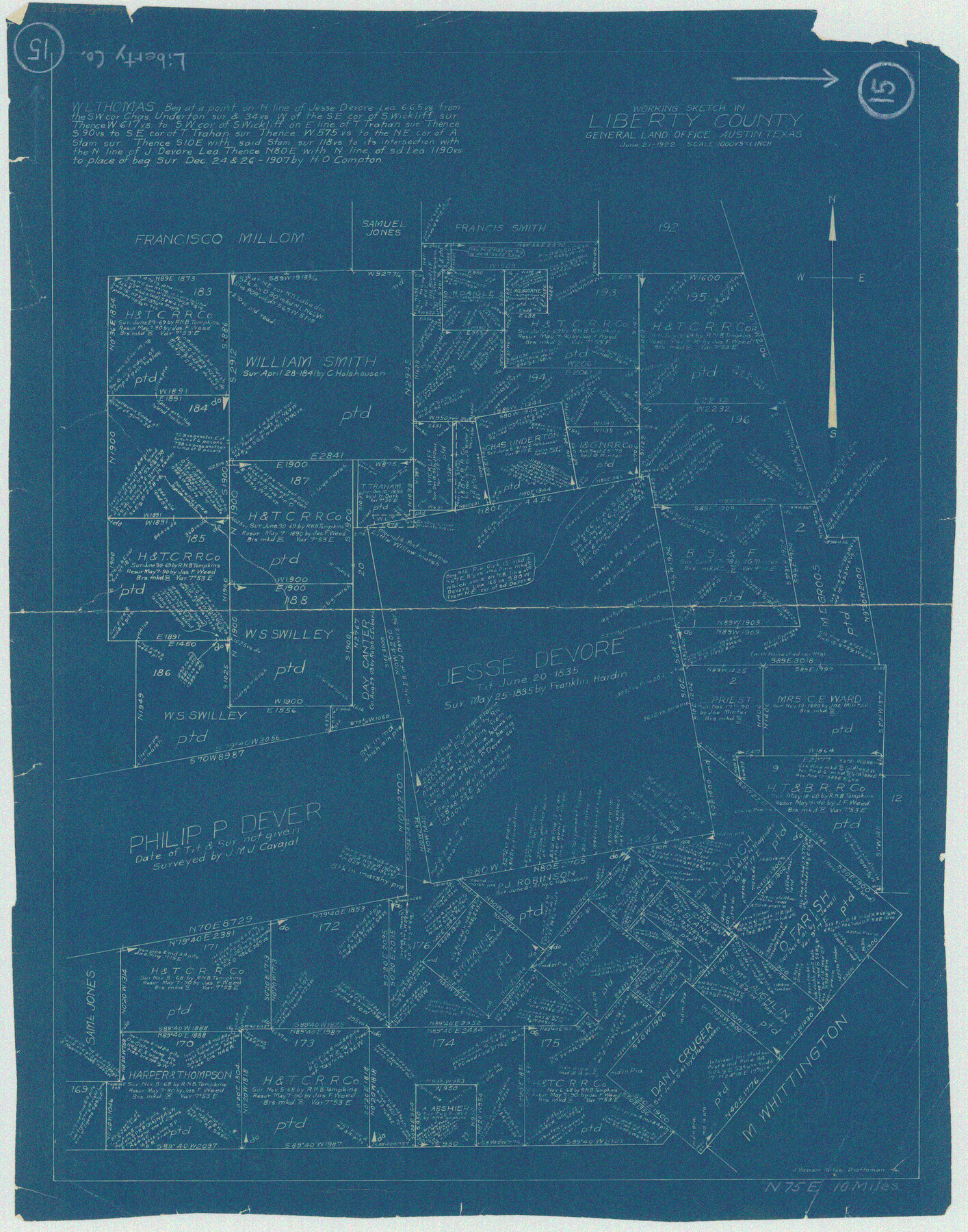
Liberty County Working Sketch 15
-
Map/Doc
70474
-
Collection
General Map Collection
-
Object Dates
6/21/1922 (Creation Date)
-
People and Organizations
J. Bascom Giles (Draftsman)
-
Counties
Liberty
-
Subjects
Surveying Working Sketch
-
Height x Width
19.0 x 15.0 inches
48.3 x 38.1 cm
-
Scale
1" = 1000 varas
Part of: General Map Collection
No. 2 Chart of Corpus Christi Pass, Texas

Print $20.00
- Digital $50.00
No. 2 Chart of Corpus Christi Pass, Texas
1878
Size 18.2 x 27.3 inches
Map/Doc 73017
Garza County Rolled Sketch R-2

Print $40.00
- Digital $50.00
Garza County Rolled Sketch R-2
Size 36.0 x 50.2 inches
Map/Doc 9046
Brazoria County NRC Article 33.136 Sketch 8

Print $20.00
- Digital $50.00
Brazoria County NRC Article 33.136 Sketch 8
2006
Size 17.1 x 11.2 inches
Map/Doc 83649
Flight Mission No. CRC-2R, Frame 123, Chambers County

Print $20.00
- Digital $50.00
Flight Mission No. CRC-2R, Frame 123, Chambers County
1956
Size 18.6 x 22.4 inches
Map/Doc 84747
Red River County Working Sketch 60

Print $20.00
- Digital $50.00
Red River County Working Sketch 60
1973
Size 27.1 x 40.0 inches
Map/Doc 72043
Harris County Rolled Sketch 60

Print $20.00
- Digital $50.00
Harris County Rolled Sketch 60
1927
Size 27.4 x 21.3 inches
Map/Doc 6106
Map of Donley County

Print $20.00
- Digital $50.00
Map of Donley County
1894
Size 44.6 x 35.8 inches
Map/Doc 16823
Upshur County

Print $20.00
- Digital $50.00
Upshur County
1945
Size 37.7 x 33.5 inches
Map/Doc 77442
Flight Mission No. CRE-1R, Frame 124, Jackson County

Print $20.00
- Digital $50.00
Flight Mission No. CRE-1R, Frame 124, Jackson County
1956
Size 16.1 x 15.9 inches
Map/Doc 85335
Castro County Sketch File 5a

Print $8.00
- Digital $50.00
Castro County Sketch File 5a
1904
Size 11.2 x 8.7 inches
Map/Doc 17491
Upton County Sketch File 11

Print $20.00
- Digital $50.00
Upton County Sketch File 11
1919
Size 22.5 x 27.6 inches
Map/Doc 12511
Flight Mission No. BRA-16M, Frame 61, Jefferson County

Print $20.00
- Digital $50.00
Flight Mission No. BRA-16M, Frame 61, Jefferson County
1953
Size 18.6 x 22.2 inches
Map/Doc 85678
You may also like
Runnels County Sketch File 24

Print $20.00
Runnels County Sketch File 24
1930
Size 25.2 x 21.3 inches
Map/Doc 12258
Wise County Working Sketch 2

Print $20.00
- Digital $50.00
Wise County Working Sketch 2
1940
Size 30.1 x 41.9 inches
Map/Doc 72616
Throckmorton County

Print $20.00
- Digital $50.00
Throckmorton County
1943
Size 46.7 x 37.4 inches
Map/Doc 95653
Potter County Sketch File 3

Print $20.00
- Digital $50.00
Potter County Sketch File 3
1883
Size 37.5 x 47.6 inches
Map/Doc 10574
Lands of Gunter & Munson and Maddox Bros. & Anderson, Tom Green Co. Tex.

Print $20.00
- Digital $50.00
Lands of Gunter & Munson and Maddox Bros. & Anderson, Tom Green Co. Tex.
Size 20.4 x 30.7 inches
Map/Doc 75787
Pecos County Rolled Sketch 50

Print $20.00
- Digital $50.00
Pecos County Rolled Sketch 50
1913
Size 23.5 x 13.0 inches
Map/Doc 7226
Mills County Working Sketch 19

Print $20.00
- Digital $50.00
Mills County Working Sketch 19
1963
Size 18.6 x 31.2 inches
Map/Doc 71049
Flight Mission No. BQR-13K, Frame 25, Brazoria County

Print $20.00
- Digital $50.00
Flight Mission No. BQR-13K, Frame 25, Brazoria County
1952
Size 18.8 x 22.4 inches
Map/Doc 84073
Current Miscellaneous File 36

Print $12.00
- Digital $50.00
Current Miscellaneous File 36
Size 10.3 x 12.4 inches
Map/Doc 73952
Pecos County Working Sketch 58

Print $20.00
- Digital $50.00
Pecos County Working Sketch 58
1949
Size 20.5 x 22.0 inches
Map/Doc 71530
Map of Jefferson County Texas

Print $20.00
- Digital $50.00
Map of Jefferson County Texas
1879
Size 23.3 x 20.6 inches
Map/Doc 3729
Flight Mission No. CRE-1R, Frame 129, Jackson County

Print $20.00
- Digital $50.00
Flight Mission No. CRE-1R, Frame 129, Jackson County
1956
Size 18.5 x 22.3 inches
Map/Doc 85337