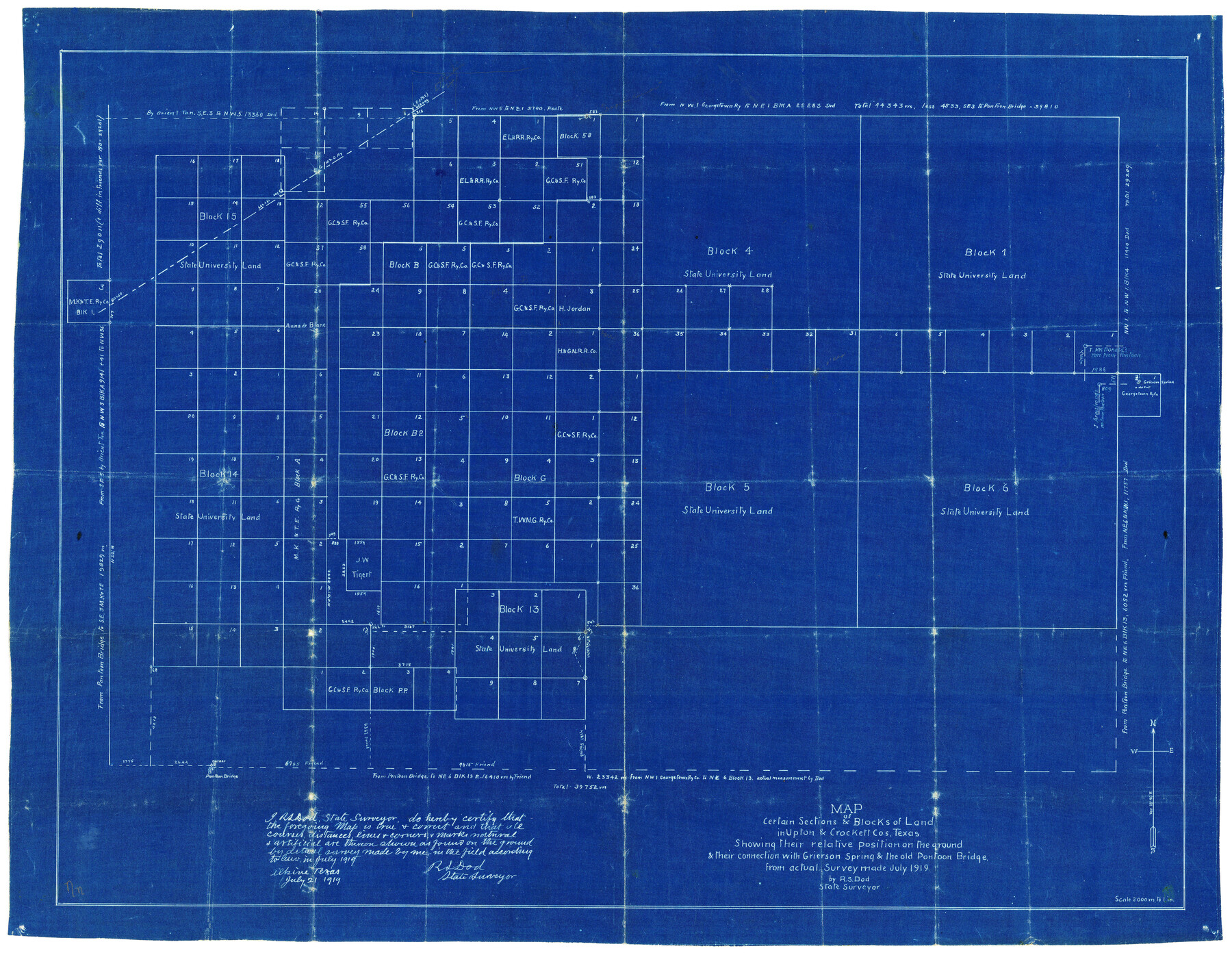
Upton County Sketch File 11
Map of Certain Sections & Blocks of Land in Upton & Crockett Cos. Texas Shwoing Their Relative Position on the Ground & Their Connection with Grierson Spring & the Old Pontoon Bridge.
-
Map/Doc
12511
-
Collection
General Map Collection
-
Object Dates
7/2/1919 (Creation Date)
-
People and Organizations
R.S. Dod (Surveyor/Engineer)
-
Counties
Upton
-
Subjects
Surveying Sketch File
-
Height x Width
22.5 x 27.6 inches
57.2 x 70.1 cm
-
Medium
blueprint/diazo
-
Features
Pontoon Bridge
Grierson Spring
Part of: General Map Collection
Terrell County Rolled Sketch 22

Print $20.00
- Digital $50.00
Terrell County Rolled Sketch 22
1903
Size 27.1 x 24.1 inches
Map/Doc 7930
Edwards County Working Sketch Graphic Index - east part - sheet 1

Print $40.00
- Digital $50.00
Edwards County Working Sketch Graphic Index - east part - sheet 1
1975
Size 54.8 x 39.9 inches
Map/Doc 76533
Presidio County Rolled Sketch D1

Print $20.00
- Digital $50.00
Presidio County Rolled Sketch D1
Size 18.7 x 16.1 inches
Map/Doc 78524
Garza County Rolled Sketch 6C

Print $20.00
- Digital $50.00
Garza County Rolled Sketch 6C
Size 24.7 x 19.2 inches
Map/Doc 5997
Right of Way and Track Map - Houston & Texas Central R.R. operated by the T. and N. O. R.R. Co. - Main Line

Print $40.00
- Digital $50.00
Right of Way and Track Map - Houston & Texas Central R.R. operated by the T. and N. O. R.R. Co. - Main Line
1918
Size 25.2 x 57.8 inches
Map/Doc 82859
Harris County Sketch File 9

Print $4.00
- Digital $50.00
Harris County Sketch File 9
1861
Size 6.7 x 7.3 inches
Map/Doc 25340
Flight Mission No. DQO-1K, Frame 19, Galveston County

Print $20.00
- Digital $50.00
Flight Mission No. DQO-1K, Frame 19, Galveston County
1952
Size 18.9 x 22.6 inches
Map/Doc 84978

Brooks County Rolled Sketch 28

Print $20.00
- Digital $50.00
Brooks County Rolled Sketch 28
1947
Size 28.9 x 32.0 inches
Map/Doc 5346
[Old Coastal Chart showing Brazo Chico, Brazo de Santiago and Rio Bravo del Norte passes with depth readings]
![4661, [Old Coastal Chart showing Brazo Chico, Brazo de Santiago and Rio Bravo del Norte passes with depth readings], General Map Collection](https://historictexasmaps.com/wmedia_w700/maps/4661-1.tif.jpg)
Print $20.00
- Digital $50.00
[Old Coastal Chart showing Brazo Chico, Brazo de Santiago and Rio Bravo del Norte passes with depth readings]
1837
Size 25.7 x 39.3 inches
Map/Doc 4661
Val Verde County Rolled Sketch 72A

Print $20.00
- Digital $50.00
Val Verde County Rolled Sketch 72A
Size 15.5 x 37.8 inches
Map/Doc 8135
Flight Mission No. DQO-2K, Frame 92, Galveston County

Print $20.00
- Digital $50.00
Flight Mission No. DQO-2K, Frame 92, Galveston County
1952
Size 18.8 x 22.5 inches
Map/Doc 85019
You may also like
Upshur County

Print $20.00
- Digital $50.00
Upshur County
1945
Size 37.7 x 33.5 inches
Map/Doc 77442
Hudspeth County Working Sketch 48

Print $20.00
- Digital $50.00
Hudspeth County Working Sketch 48
1984
Size 36.6 x 46.3 inches
Map/Doc 66333
[W. T. Brewer: M. McDonald, Ralph Gilpin, A. Vanhooser, John Baker, John R. Taylor Surveys]
![90959, [W. T. Brewer: M. McDonald, Ralph Gilpin, A. Vanhooser, John Baker, John R. Taylor Surveys], Twichell Survey Records](https://historictexasmaps.com/wmedia_w700/maps/90959-1.tif.jpg)
Print $2.00
- Digital $50.00
[W. T. Brewer: M. McDonald, Ralph Gilpin, A. Vanhooser, John Baker, John R. Taylor Surveys]
Size 9.1 x 11.2 inches
Map/Doc 90959
[H. & G. N. RR. Co. Blks. 1 & 2]
![89771, [H. & G. N. RR. Co. Blks. 1 & 2], Twichell Survey Records](https://historictexasmaps.com/wmedia_w700/maps/89771-1.tif.jpg)
Print $20.00
- Digital $50.00
[H. & G. N. RR. Co. Blks. 1 & 2]
Size 40.9 x 46.6 inches
Map/Doc 89771
King County Working Sketch 1

Print $20.00
- Digital $50.00
King County Working Sketch 1
1913
Size 18.2 x 23.8 inches
Map/Doc 70165
Map of Galveston Bay from Lawrence Cove to Stevenson's Station

Print $20.00
- Digital $50.00
Map of Galveston Bay from Lawrence Cove to Stevenson's Station
1851
Size 41.5 x 30.0 inches
Map/Doc 69922
Angelina County Working Sketch 51

Print $20.00
- Digital $50.00
Angelina County Working Sketch 51
1988
Size 44.0 x 23.0 inches
Map/Doc 67135
Map of the Lands Surveyed by the Memphis, El Paso & Pacific R.R. Company

Print $20.00
- Digital $50.00
Map of the Lands Surveyed by the Memphis, El Paso & Pacific R.R. Company
1860
Size 18.6 x 19.0 inches
Map/Doc 4846
Brewster County Sketch File N-23

Print $6.00
- Digital $50.00
Brewster County Sketch File N-23
1951
Size 14.4 x 9.0 inches
Map/Doc 15697
Map of the Southern part of Texas

Print $20.00
- Digital $50.00
Map of the Southern part of Texas
1831
Size 17.5 x 21.3 inches
Map/Doc 94442
Houston County Working Sketch 7

Print $20.00
- Digital $50.00
Houston County Working Sketch 7
1935
Size 24.7 x 36.8 inches
Map/Doc 66237
[Coordinates for Block H, Sections 1 and 2 and Block C41, Section 4]
![92566, [Coordinates for Block H, Sections 1 and 2 and Block C41, Section 4], Twichell Survey Records](https://historictexasmaps.com/wmedia_w700/maps/92566-1.tif.jpg)
Print $3.00
- Digital $50.00
[Coordinates for Block H, Sections 1 and 2 and Block C41, Section 4]
1940
Size 11.4 x 17.4 inches
Map/Doc 92566