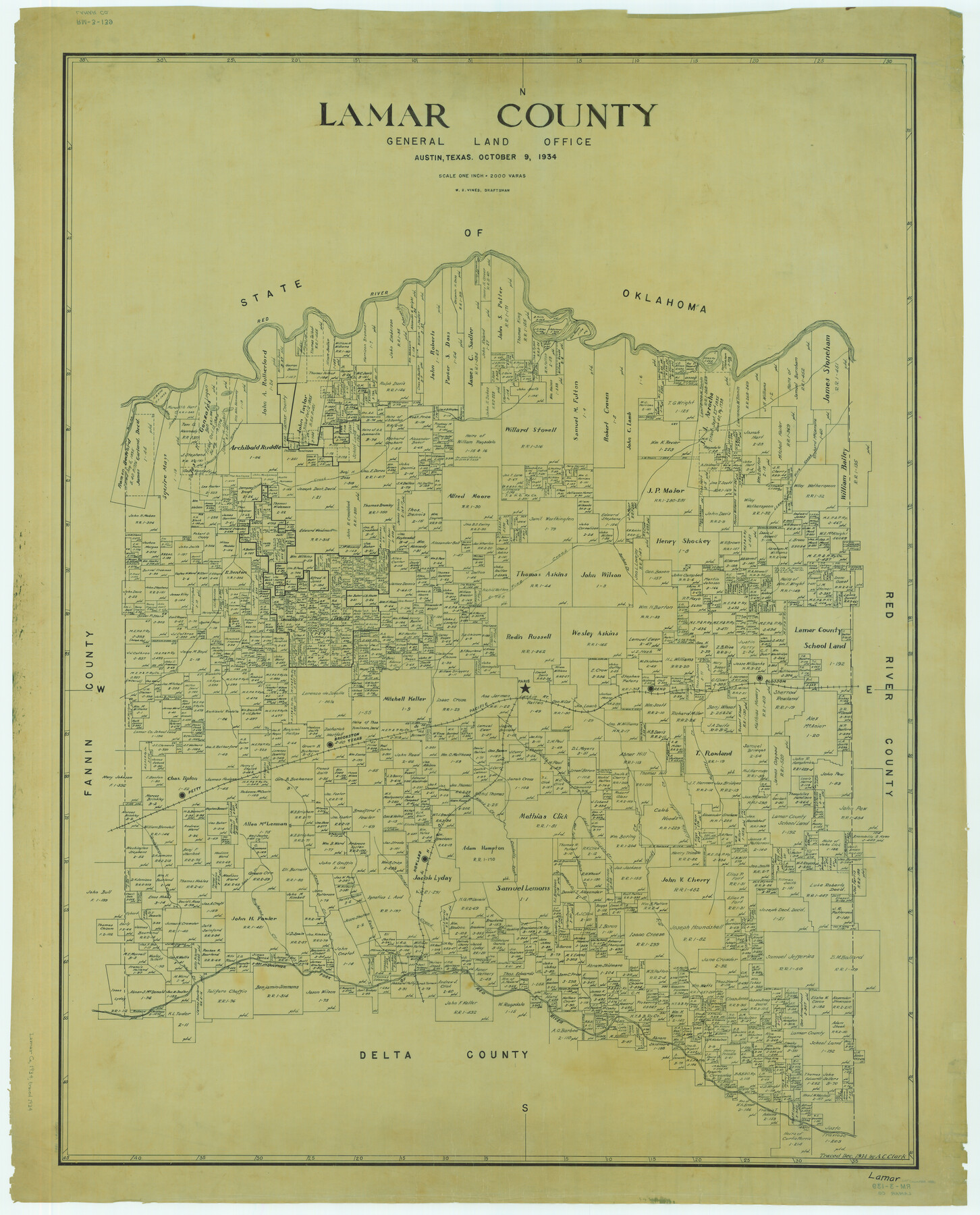
Lamar County
RM-3-139
-
Map/Doc
1880
-
Collection
General Map Collection
-
Object Dates
1934/10/9 (Creation Date)
-
People and Organizations
Texas General Land Office (Publisher)
W.S. Vines (Draftsman)
-
Counties
Lamar
-
Subjects
County
-
Height x Width
50.2 x 40.5 inches
127.5 x 102.9 cm
-
Comments
Traced in December 1934 by A. C. Clark.
Part of: General Map Collection
Right of Way and Track Map, The Wichita Falls & Southern Railway

Print $40.00
- Digital $50.00
Right of Way and Track Map, The Wichita Falls & Southern Railway
1942
Size 25.5 x 92.5 inches
Map/Doc 64513
Blanco County Sketch File 50

Print $6.00
- Digital $50.00
Blanco County Sketch File 50
1995
Size 11.5 x 8.8 inches
Map/Doc 14695
Flight Mission No. DQO-8K, Frame 45, Galveston County

Print $20.00
- Digital $50.00
Flight Mission No. DQO-8K, Frame 45, Galveston County
1952
Size 18.8 x 22.3 inches
Map/Doc 85152
Kimble County Working Sketch 3

Print $20.00
- Digital $50.00
Kimble County Working Sketch 3
1897
Size 16.4 x 21.4 inches
Map/Doc 70071
Angelina County Working Sketch 24

Print $20.00
- Digital $50.00
Angelina County Working Sketch 24
1954
Size 27.0 x 23.0 inches
Map/Doc 67106
Wharton County Sketch File 21

Print $40.00
- Digital $50.00
Wharton County Sketch File 21
1911
Size 14.8 x 13.0 inches
Map/Doc 39986
G. C. & S. F. Ry. Alinement [sic] and Right of Way Map of Dallas Branch, Johnson County, Texas
![64652, G. C. & S. F. Ry. Alinement [sic] and Right of Way Map of Dallas Branch, Johnson County, Texas, General Map Collection](https://historictexasmaps.com/wmedia_w700/maps/64652.tif.jpg)
Print $40.00
- Digital $50.00
G. C. & S. F. Ry. Alinement [sic] and Right of Way Map of Dallas Branch, Johnson County, Texas
1925
Size 37.6 x 87.9 inches
Map/Doc 64652
Pecos County Sketch File 114

Print $18.00
- Digital $50.00
Pecos County Sketch File 114
1912
Size 13.3 x 8.9 inches
Map/Doc 34074

Sketch D Showing the progress of Section IV 1845 to 1852

Print $20.00
- Digital $50.00
Sketch D Showing the progress of Section IV 1845 to 1852
1852
Size 22.8 x 13.0 inches
Map/Doc 97208
Trinity River, Terrell Sheet/Kings Creek

Print $20.00
- Digital $50.00
Trinity River, Terrell Sheet/Kings Creek
1930
Size 42.3 x 19.7 inches
Map/Doc 65229
Brazoria County Sketch File 20

Print $40.00
- Digital $50.00
Brazoria County Sketch File 20
1853
Size 22.3 x 15.0 inches
Map/Doc 10953
You may also like
Eastland County Rolled Sketch 3

Print $20.00
- Digital $50.00
Eastland County Rolled Sketch 3
1893
Size 24.4 x 41.3 inches
Map/Doc 5773

Jefferson County Rolled Sketch 45

Print $20.00
- Digital $50.00
Jefferson County Rolled Sketch 45
1959
Size 31.2 x 27.3 inches
Map/Doc 6402
Shelby County

Print $20.00
- Digital $50.00
Shelby County
1945
Size 41.6 x 45.9 inches
Map/Doc 73288
Flight Mission No. DIX-10P, Frame 72, Aransas County

Print $20.00
- Digital $50.00
Flight Mission No. DIX-10P, Frame 72, Aransas County
1956
Size 18.8 x 22.4 inches
Map/Doc 83933
Andrews County Rolled Sketch 20

Print $20.00
- Digital $50.00
Andrews County Rolled Sketch 20
Size 31.6 x 40.0 inches
Map/Doc 8395
Lubbock County Sketch File 12

Print $6.00
- Digital $50.00
Lubbock County Sketch File 12
1933
Size 11.1 x 8.6 inches
Map/Doc 30435
Trinity River, Watershed

Print $20.00
- Digital $50.00
Trinity River, Watershed
1925
Size 46.9 x 40.5 inches
Map/Doc 65255
Trinity County

Print $20.00
- Digital $50.00
Trinity County
1946
Size 42.5 x 42.8 inches
Map/Doc 73306
Grayson County Working Sketch 4

Print $20.00
- Digital $50.00
Grayson County Working Sketch 4
1939
Size 27.6 x 41.0 inches
Map/Doc 63243
Taylor County Rolled Sketch 30B

Print $20.00
- Digital $50.00
Taylor County Rolled Sketch 30B
Size 17.5 x 11.6 inches
Map/Doc 76411
Supplemental Plat, T. 4S., R. 14W., Indian Meridian, Oklahoma

Print $4.00
- Digital $50.00
Supplemental Plat, T. 4S., R. 14W., Indian Meridian, Oklahoma
1924
Size 17.4 x 23.1 inches
Map/Doc 75148